
Sierra Blanca, Texas facts for kids
Quick facts for kids
Sierra Blanca, Texas
|
|
|---|---|

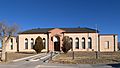
Sierra Blanca with "SB" on mountain in the background
|
|
 |
|
| Country | United States |
| State | Texas |
| County | Hudspeth |
| Area | |
| • Total | 4.8 sq mi (12.4 km2) |
| • Land | 4.7 sq mi (12.3 km2) |
| • Water | 0.04 sq mi (0.1 km2) |
| Elevation | 4,528 ft (1,380 m) |
| Population
(2010)
|
|
| • Total | 553 |
| • Density | 116/sq mi (44.9/km2) |
| Time zone | UTC-7 (Mountain (MST)) |
| • Summer (DST) | UTC-6 (MDT) |
| ZIP code |
79851
|
| Area code(s) | 915 |
| FIPS code | 48-67772 |
| GNIS feature ID | 1368253 |
Sierra Blanca is an unincorporated area in Hudspeth County, Texas, United States. It is also the county seat of the county and the namesake of a census-designated place (CDP) in which it is located. The town is part of the Trans-Pecos region of far West Texas, is located northeast of the Mexican border and is within the Mountain Time Zone. As of the 2010 census, its population was 553.
The town was founded in 1881 at the completion point of a long-sought southern transcontinental railway. Sierra Blanca has served as the junction of the Southern Pacific and Missouri Pacific railroads. Hudspeth County was formed in 1917 from El Paso County. Sierra Blanca was named the county seat, and has the only adobe courthouse in Texas.
The town continues to accommodate travelers between Van Horn and El Paso along Interstate 10, which is the main route that connects Texas from west to southeast. The town was named for the nearby Sierra Blanca Mountain, which was in turn named for the white poppies that grew there (sierra blanca is Spanish for "white mountain").
The letters "SB" can be seen on a nearby mountain from Interstate 10.
Geography

Sierra Blanca is found in Far West Texas, a subdivision of West Texas located at 31°10′55″N 105°20′27″W / 31.18194°N 105.34083°W (31.182009, -105.340843) 4,520 feet above sea level. The city is part of the Trans-Pecos region within the most mountainous and arid portion of Texas. The town is located in Hudspeth County which is large and sparsely populated. Sierra Blanca (White Mountain), at an elevation over 7,000 feet (2,100 m) above sea level, towers over the town and is the most prominent mountain peak of the surrounding mountainous terrain. According to the Environmental Protection Agency, Sierra Blanca has 99% clean air and 100% clean water.
According to the United States Census Bureau, the CDP has a total area of 4.1 square miles (11 km2), of which 4.1 square miles (11 km2) is land and 0.04 square miles (0.10 km2) (0.73%) is water. Soil in the surrounding area is mostly non-arable and cannot sustain large scale farming. Due to the high altitude of the city, it has a cooler climate than other areas of the Chihuahuan Desert.
Summer days are hot with cool summer nights. The city occasionally experiences high winds and dust storms. June is regularly the warmest month with the highest recorded temperature in town was 109 °F (43 °C) in 1994. During the winter the jet stream will periodically dip far south and bring extremely low temperatures. December is usually the coolest month and the lowest temperature recorded was −10 °F (−23 °C) in 1985.
Normally, the city receives less than 1 inch (25 mm) of snow annually. During the hurricane season large tropical storms can sometimes bring large amounts of precipitation to the arid mountainous region and can cause flash flooding. The city on average has 293 sunny days and 43 days of precipitation. Rainfall is low; the town and vicinity receive an average of 11.27 inches (286 mm) of rainfall annually.
| Climate data for Sierra Blanca, Texas | |||||||||||||
|---|---|---|---|---|---|---|---|---|---|---|---|---|---|
| Month | Jan | Feb | Mar | Apr | May | Jun | Jul | Aug | Sep | Oct | Nov | Dec | Year |
| Average high °F (°C) | 58 (14) |
63 (17) |
69 (21) |
78 (26) |
87 (31) |
94 (34) |
92 (33) |
90 (32) |
87 (31) |
78 (26) |
67 (19) |
58 (14) |
77 (25) |
| Average low °F (°C) | 26 (−3) |
29 (−2) |
35 (2) |
43 (6) |
52 (11) |
61 (16) |
64 (18) |
62 (17) |
56 (13) |
44 (7) |
33 (1) |
26 (−3) |
44 (7) |
| Average precipitation inches (mm) | 0.40 (10) |
0.68 (17) |
0.30 (7.6) |
0.33 (8.4) |
0.52 (13) |
1.13 (29) |
2.13 (54) |
2.15 (55) |
1.45 (37) |
1.15 (29) |
0.41 (10) |
0 (0) |
11.27 (286) |
Demographics

As of the 2010 census, 553 people, 172 households, and 126 families were residing in the CDP. The population density was 116.0 people/sq mi (50.6/km2). The 227 housing units averaged 55.8/sq mi (21.5/km2). The racial makeup of the CDP was 83.91% White, 3.44% Native American, 3.25% Black, 1.45% Asian, 7.96% from other races, and 3.56% from two or more races. Latinos of any race were 72.61% of the population.
Of the 172 households, 40.2% had children under 18 living with them, 45.72% were married couples living together, 13.0% had a female householder with no husband present, and 31.0% were not families. About 28.3% of all households were made up of individuals, and 11.4% had someone living alone who was 65 or older. The average household size was 2.63, and the average family size was 3.31.
In the CDP, theage distribution was 29.8% under 18, 11.8% from 18 to 24, 30.8% from 25 to 44, 18.4% from 45 to 64, and 9.2% who were 65 or older. The median age was 34.3 years. For every 100 females, there were 96.0 males. For every 100 females age 18 and over, there were 101.1 males. The median income for a household in the CDP was $32,464. The per capita income for the CDP was $14,682. About 19.6% of families and 22.5% of the population were below the poverty line, including 28.3% of those under age 18 and 32.6% of those age 65 or over.
Economy
The cost of living in Sierra Blanca is about 20% less than the US average. The CDP has a home ownership rate of 49.5%. The median home is valued at $54,600 with a 1.94% annual appreciation.
Starting in 1992, a few miles from Sierra Blanca was the location of a sludge dump that received 250 tons of treated sewage each day by train from New York City. The practice was discontinued in 2001, after local complaints about odor and negative impact on health.
In the late 1990s, the Texas Low-Level Radioactive Waste Disposal Authority proposed a nuclear waste site near Sierra Blanca. The waste site was thought to bring an economic boost to the town. This proposal was eventually declined, citing concerns about the site being in the most seismically active region of Texas.
Press reports indicated that in 2013, the town supported three restaurants and a motel. No grocery store is in the community.
Education
Sierra Blanca is served by the Sierra Blanca Independent School District; it spends an annual average of $6,343 per student. On average, the schools have 10.9 students per teacher. For the demographic group older than 25 years, 68.6% have a high school degree, 3.2% have a bachelor's degree, and 2.6% have a graduate degree.
Hudspeth County is in the official service area of El Paso Community College.
Images for kids
-
Hudspeth County Courthouse

See also
 In Spanish: Sierra Blanca (Texas) para niños
