
Silverton, Colorado facts for kids
Quick facts for kids
Silverton, Colorado
|
|
|---|---|
 |
|

Location of Silverton in San Juan County, Colorado.
|
|
| Country | |
| State | |
| County | San Juan County - seat |
| Established | 1874 |
| Incorporated | November 15, 1885 |
| Government | |
| • Type | Statutory Town |
| Area | |
| • Total | 0.83 sq mi (2.16 km2) |
| • Land | 0.83 sq mi (2.16 km2) |
| • Water | 0.00 sq mi (0.00 km2) |
| Elevation | 9,318 ft (2,840 m) |
| Population
(2010)
|
|
| • Total | 637 |
| • Estimate
(2019)
|
663 |
| • Density | 794.01/sq mi (306.60/km2) |
| Time zone | UTC-7 (Mountain (MST)) |
| • Summer (DST) | UTC-6 (MDT) |
| ZIP code |
81433 (PO Box)
|
| Area code(s) | 970 Exchange: 357 |
| FIPS code | 08-70580 |
| GNIS feature ID | 0204750 |
| Website | Town of Silverton |
Silverton is a Statutory Town that is the county seat, the most populous community, and the only incorporated municipality in San Juan County, Colorado, United States. The town is located in a remote part of the western San Juan Mountains, a range of the Rocky Mountains. The first mining claims were made in mountains above the Silverton in 1860, near the end of the Colorado Gold Rush and when the land was still controlled by the Utes. Silverton was established shortly after the Utes ceded the region in the 1873 Brunot Agreement, and the town boomed from silver mining until the Panic of 1893 led to a collapse of the silver market, and boomed again from gold mining until the recession caused by the Panic of 1907. The entire town is included as a federally designated National Historic Landmark District, the Silverton Historic District.
Originally called "Bakers Park", Silverton sits in a flat area of the Animas River valley and is surrounded by steep peaks. Most of the peaks surrounding Silverton are thirteeners, the highest being Storm Peak, at 13,487 feet. The town is less than 15 miles from 7 of Colorado's 53 fourteeners, and is known as one of the premier gateways into the Colorado backcountry.
Silverton's last operating mine closed in 1992, and the community now depends primarily on tourism and government remediation and preservation projects. Silverton is well known because of the Durango and Silverton Narrow Gauge Railroad, a former mine train that is now a National Historic Landmark, and internationally recognized events such as the Hardrock Hundred Mile Endurance Run. The town population reached 637 in the U.S. Census 2010.
Contents
Geography
According to the United States Census Bureau, the town has a total area of 0.8 square miles (2.1 km2), all of it land. Silverton is one of the highest towns in the United States, at 9,318 feet (2,836 m) above sea level. This is also where the book "The Christopher Killer" takes place.
Climate
Silverton has an alpine subarctic climate (Köppen climate classification Dfc) with very cold, snowy winters and cool to warm summers with adequate precipitation year-round.
| Climate data for 1906-2005 Silverton, Colorado. | |||||||||||||
|---|---|---|---|---|---|---|---|---|---|---|---|---|---|
| Month | Jan | Feb | Mar | Apr | May | Jun | Jul | Aug | Sep | Oct | Nov | Dec | Year |
| Average high °F (°C) | 34.0 (1.1) |
36.6 (2.6) |
40.6 (4.8) |
47.3 (8.5) |
57.6 (14.2) |
67.9 (19.9) |
73.1 (22.8) |
70.5 (21.4) |
64.7 (18.2) |
55.1 (12.8) |
43.2 (6.2) |
35.1 (1.7) |
52.2 (11.2) |
| Average low °F (°C) | −1.9 (−18.8) |
1.0 (−17.2) |
8.1 (−13.3) |
18.5 (−7.5) |
26.4 (−3.1) |
31.9 (−0.1) |
37.9 (3.3) |
37.2 (2.9) |
30.3 (−0.9) |
22.0 (−5.6) |
9.5 (−12.5) |
0.2 (−17.7) |
18.4 (−7.6) |
| Average precipitation inches (mm) | 1.68 (43) |
1.75 (44) |
2.30 (58) |
1.72 (44) |
1.46 (37) |
1.39 (35) |
2.72 (69) |
3.10 (79) |
2.81 (71) |
2.34 (59) |
1.49 (38) |
1.73 (44) |
24.50 (622) |
| Average snowfall inches (cm) | 25.8 (66) |
25.3 (64) |
28.4 (72) |
17.3 (44) |
4.3 (11) |
0.3 (0.76) |
0.0 (0.0) |
0.0 (0.0) |
0.9 (2.3) |
8.5 (22) |
20.0 (51) |
24.0 (61) |
154.9 (393) |
| Source: The Western Regional Climate Center | |||||||||||||
History
|
Silverton Historic District
|
|

Grand Imperial Hotel, Silverton Historic District
|
|
| Lua error in Module:Location_map at line 420: attempt to index field 'wikibase' (a nil value). | |
| Location | Silverton, Colorado |
|---|---|
| Built | 1882 |
| Architect | Multiple |
| Architectural style | Late Victorian (original) Other (increase) |
| NRHP reference No. | 66000255 (original) and 97000247 (increase) |
| Significant dates | |
| Added to NRHP | October 15, 1966 (original) April 03, 1997 (boundary increase) |
| Designated NHLD | July 04, 1961 |
Charles Baker's group of prospectors found traces of placer gold in the San Juan Mountains in 1860 at Eureka, Colorado. Forced out by the Ute Tribe in 1861, who had been awarded the area in a US treaty. The prospectors returned in 1871, when lode gold was found in the Little Giant vein at Arrastre Gulch. The miners were allowed to stay after the Brunot Treaty of 13 Sept. 1873. In exchange for giving up 4 million acres, the Southern Ute Indian Reservation received $25,000 per year.
In August 1873, George Howard and R.J. McNutt discovered the Sunnyside silver vein along Hurricane Peak. Gold was then discovered in 1882. The Sunnyside Mine was shut down after the 1929 stock market crash, but was acquired by Standard Metals Corp. in 1959, and reopened, finding gold in 1973 with the Little Mary vein. Half of Colorado's gold production in the 1970s came from the Sunnyside. Disaster occurred on 4 June 1978, when the water from Lake Emma collapsed a mine shaft (when miners weren't present,) and then traveled quickly through the tunnels, shooting out a portal along Cement Creek with a force that toppled a 20-ton locomotive. The mine reopened after two years, but was acquired by Echo Bay Mines in 1986, which operated the mine for another five years. The nearby Gold King mine breached and spilled into Cement Creek, causing the 2015 Gold King Mine waste water spill.
Demographics
| Historical population | |||
|---|---|---|---|
| Census | Pop. | %± | |
| 1900 | 1,360 | — | |
| 1910 | 2,153 | 58.3% | |
| 1920 | 1,150 | −46.6% | |
| 1930 | 1,301 | 13.1% | |
| 1940 | 1,127 | −13.4% | |
| 1950 | 1,375 | 22.0% | |
| 1960 | 822 | −40.2% | |
| 1970 | 797 | −3.0% | |
| 1980 | 794 | −0.4% | |
| 1990 | 716 | −9.8% | |
| 2000 | 531 | −25.8% | |
| 2010 | 637 | 20.0% | |
| 2019 (est.) | 663 | 4.1% | |
| U.S. Decennial Census | |||
As of the census of 2000, there were 531 people, 255 households, and 149 families residing in the town. The population density was 656.0 people per square mile (253.1/km2). There were 430 housing units at an average density of 531.2 per square mile (205.0/km2). The racial makeup of the town was 97.36% White, 0.75% Native American, 0.38% Pacific Islander, 0.75% from other races, and 0.75% from two or more races. Hispanic or Latino of any race were 7.72% of the population.
There were 255 households, out of which 24.7% had children under the age of 18 living with them, 43.5% were married couples living together, 9.4% had a female householder with no husband present, and 41.2% were non-families. 36.9% of all households were made up of individuals, and 4.7% had someone living alone who was 65 years of age or older. The average household size was 2.06 and the average family size was 2.63.
In the town, the population was spread out, with 20.7% under the age of 18, 4.0% from 18 to 24, 28.4% from 25 to 44, 39.9% from 45 to 64, and 7.0% who were 65 years of age or older. The median age was 44 years. For every 100 females, there were 108.2 males. For every 100 females age 18 and over, there were 110.5 males.
The median income for a household in the town was $30,486, and the median income for a family was $39,375. Males had a median income of $30,588 versus $19,886 for females. The per capita income for the town was $16,839. About 14.0% of families and 21.6% of the population were below the poverty line, including 29.4% of those under age 18 and 7.1% of those age 65 or over.
The local school system has a total of 53 K-through-12 students as of November 2006.
In popular culture
In the novel The Christopher Killer by Alane Ferguson, the main setting is in Silverton.
Country singer C. W. McCall recorded "The Silverton," about the Silverton and Durango Railroad, on his 1975 album Black Bear Road.
Silverton was the setting for some of Shaun White's 2010 Olympic training. Taking advantage of the secluded locale, terrain and snow fall, Red Bull built a private halfpipe for the snowboarder. Known as "Project X," the halfpipe was completed in Feb. 2009 on the backside of Silverton Mountain and allowed the boarder to perfect some of his gold medal winning moves far from prying eyes.
The 2003 Microsoft video game Freelancer features a Colorado solar system including the 'Silverton' asteroid field.
Gallery
-
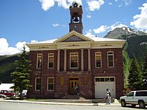
Silverton city hall
-
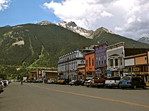
Downtown Silverton
-
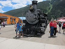
Passengers arriving on the narrow gauge railroad from Durango, CO
-
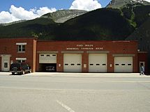
Fred Wolfe Memorial Carriage House and the Silverton Clinic
-
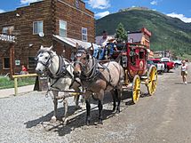
Silverton Stagecoach Rides on Blair Street
-
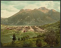
Silverton and Sultan Mountain in 1901
-
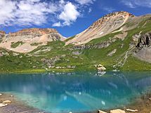
Ice Lake in the Ice Lake Basin of the Weminuche Wilderness, near Silverton
-
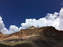
Golden Horn in the Weminuche Wilderness/San Juan National Forest outside of Silverton. 13,769 ft peak elevation.


Notable people
- Robert Baer, author and former case officer at the Central Intelligence Agency briefly retired here.
- Anton Larson, Trooper in Teddy Roosevelt's Rough Riders, Spanish–American War
- Arthur Pink, evangelical pastor and writer, lived in Silverton briefly
- Harold Ross, founding editor of The New Yorker who was a native of Aspen, Colorado
- Bill Alsup, former IndyCar driver
Images for kids
-
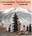
1911 Brochure inviting tourists to Silverton

See also
 In Spanish: Silverton (Colorado) para niños
