Simpsonville, South Carolina facts for kids
Quick facts for kids
Simpsonville, South Carolina
|
||
|---|---|---|

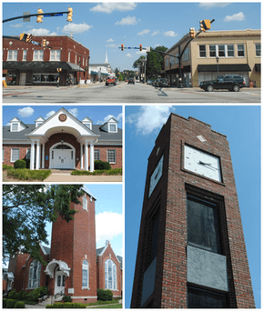
From top, left to right: Downtown, City Hall, Simpsonville Baptist Church, Simpsonville Clock Tower
|
||
|
||
| Motto(s):
"Simply Home"
|
||

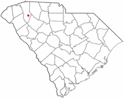
Location of Simpsonville, South Carolina
|
||
| Country | United States | |
| State | South Carolina | |
| County | Greenville | |
| Area | ||
| • Total | 9.37 sq mi (24.27 km2) | |
| • Land | 9.35 sq mi (24.22 km2) | |
| • Water | 0.02 sq mi (0.05 km2) | |
| Elevation | 866 ft (264 m) | |
| Population
(2020)
|
||
| • Total | 22,234 | |
| • Density | 2,372.89/sq mi (916.18/km2) | |
| Time zone | UTC−5 (Eastern (EST)) | |
| • Summer (DST) | UTC−4 (EDT) | |
| ZIP codes |
29680-29681
|
|
| Area code(s) | 864 | |
| FIPS code | 45-66580 | |
| GNIS feature ID | 1250898 | |
Simpsonville is a city in Greenville County, South Carolina, United States. It is part of the Greenville–Mauldin–Easley Metropolitan Statistical Area. The population was 22,234 at the 2020 census, up from 18,238 in 2010. Simpsonville is part of the "Golden Strip", along with Mauldin and Fountain Inn, an area which is noted for having low unemployment due to a diversity of industries including H.B. Fuller, KEMET, Sealed Air and Milliken.
Contents
History
The Burdette Building, Cureton-Huff House, Hopkins Farm, and Simpsonville Baptist Church are listed on the National Register of Historic Places.
Geography
Simpsonville is located in southeastern Greenville County at 34°44′0″N 82°15′36″W / 34.73333°N 82.26000°W (34.733375, -82.260001), between Mauldin to the northwest and Fountain Inn to the southeast. The center of town has an elevation of 866 feet (264 m) above sea level.
South Carolina Highway 14 runs through the center of Simpsonville as Main Street, leading north 16 miles (26 km) to Greer and southeast 5 miles (8 km) to the center of Fountain Inn. The center of Mauldin is 4.5 miles (7.2 km) to the northwest via South Carolina Highway 417. Interstate 385 passes through Simpsonville west of the city center, with access from Exits 26 through 29. I-385 leads northwest 14 miles (23 km) to the center of Greenville and southeast 28 miles (45 km) to Interstate 26 near Clinton. Columbia, the state capital, is 89 miles (143 km) southeast of Simpsonville.
According to the United States Census Bureau, Simpsonville has a total area of 8.83 square miles (22.88 km2), of which 8.81 square miles (22.82 km2) are land and 0.02 square miles (0.06 km2), or 0.28%, are water.
Demographics
| Historical population | |||
|---|---|---|---|
| Census | Pop. | %± | |
| 1900 | 195 | — | |
| 1910 | 521 | 167.2% | |
| 1920 | 566 | 8.6% | |
| 1930 | 1,400 | 147.3% | |
| 1940 | 1,298 | −7.3% | |
| 1950 | 1,529 | 17.8% | |
| 1960 | 2,282 | 49.2% | |
| 1970 | 3,308 | 45.0% | |
| 1980 | 9,037 | 173.2% | |
| 1990 | 11,708 | 29.6% | |
| 2000 | 14,352 | 22.6% | |
| 2010 | 18,238 | 27.1% | |
| 2020 | 22,234 | 21.9% | |
| U.S. Decennial Census | |||
| Weather chart for Simpsonville | |||||||||||||||||||||||||||||||||||||||||||||||
|---|---|---|---|---|---|---|---|---|---|---|---|---|---|---|---|---|---|---|---|---|---|---|---|---|---|---|---|---|---|---|---|---|---|---|---|---|---|---|---|---|---|---|---|---|---|---|---|
| J | F | M | A | M | J | J | A | S | O | N | D | ||||||||||||||||||||||||||||||||||||
|
3.5
53
33
|
3
56
35
|
4.3
65
42
|
3.5
73
50
|
3.7
80
58
|
3.6
88
67
|
5.4
90
70
|
4.3
89
69
|
4.1
82
63
|
2.9
73
51
|
3.7
64
41
|
4.8
55
36
|
||||||||||||||||||||||||||||||||||||
| temperatures in °F precipitation totals in inches source: [1] |
|||||||||||||||||||||||||||||||||||||||||||||||
|
Metric conversion
|
|||||||||||||||||||||||||||||||||||||||||||||||
2020 census
| Race | Num. | Perc. |
|---|---|---|
| White (non-Hispanic) | 14,810 | 63.42% |
| Black or African American (non-Hispanic) | 4,320 | 18.5% |
| Native American | 54 | 0.23% |
| Asian | 463 | 1.98% |
| Pacific Islander | 20 | 0.09% |
| Other/Mixed | 1,191 | 5.1% |
| Hispanic or Latino | 2,496 | 10.69% |
As of the 2020 United States census, there were 23,354 people, 8,464 households, and 6,104 families residing in the city. The population density was 2,732.9 people per square mile (916.2 per km2). There were 9,044 housing units at an average density of 1,016.2 per square mile (392.2 per km2). 24.1% of the population was under 18, and 14.4% of the population was over 65. 51.3% of the population was female.
The median annual income for a household in the city was $71,990, and the per capita income was $32,821. 5.4% of the population were below the poverty line.
Education
Public education in Simpsonville is administered by Greenville County School District. The district operates Hillcrest High School in Simpsonville.
Abiding Peace Academy is a K2-5 grade school of the Wisconsin Evangelical Lutheran Synod in Simpsonville.
Simpsonville has a public library, a branch of the Greenville County Library System.
Culture and sports
Simpsonville's CCNB Amphitheatre at Heritage Park, named for sponsor Coastal Carolina National Bank, is an outdoor entertainment venue with seating for up to 15,000. It has hosted performers and community events since 2005.
The Simpsonville Arts Center hosts performing arts by the Mill Town Players of Pelzer. Renovation of the center was completed in February 2022.
The Women's American Basketball Association established a team based in Simpsonville to begin its first season in July 2021. Home games for the Carolina Upstate Thunder are to be played in Greenville.
Notable people
- Justin Bolli, professional golfer
- Danielle Brooks, actress, stars in Orange Is the New Black and was Tony Award-nominated for role as Sofia on Broadway in The Color Purple.
- Chandler Catanzaro, American football placekicker
- Lucas Glover, PGA Tour golfer, winner of 2009 U.S. Open Golf Championship
- Shane Hall, NASCAR driver
- Tommy Jones, professional bowler; 2005–06 PBA Player of the Year
- Jamon Meredith, offensive tackle, 2009 fifth-round draft pick of NFL's Green Bay Packers
- Emilio Pagan, pitcher for MLB's San Diego Padres
- Stephen Thompson, UFC fighter
- Travelle Wharton, offensive tackle for NFL's Carolina Panthers
See also
 In Spanish: Simpsonville (Carolina del Sur) para niños


