
Slaughter Beach, Delaware facts for kids
Quick facts for kids
Slaughter Beach, Delaware
|
|
|---|---|

Location of Slaughter Beach in Sussex County, Delaware.
|
|

Slaughter Beach, Delaware
Location in Delaware

Slaughter Beach, Delaware
Location in the United States
|
|
| Country | |
| State | |
| County | |
| Area | |
| • Total | 1.44 sq mi (3.74 km2) |
| • Land | 1.42 sq mi (3.68 km2) |
| • Water | 0.03 sq mi (0.06 km2) |
| Elevation | 7 ft (2 m) |
| Population
(2020)
|
|
| • Total | 218 |
| • Density | 153.63/sq mi (59.31/km2) |
| Time zone | UTC−5 (Eastern (EST)) |
| • Summer (DST) | UTC−4 (EDT) |
| Area code(s) | 302 |
| FIPS code | 10-67050 |
| GNIS feature ID | 214663 |
Slaughter Beach is a town in Sussex County, Delaware, United States. The population was 207 at the 2010 census, an increase of 4.5% over the past decade. It is part of the Salisbury, Maryland-Delaware Metropolitan Statistical Area.
Mispillion Lighthouse
Slaughter Beach was home to the last wooden frame lighthouse in Delaware, the Mispillion Lighthouse. The lighthouse, which overlooked the Mispillion River and Cedar Creek, was established in 1831 with a 65-foot tower. The lighthouse was on the National Register of Historic Places. In 2002 the lighthouse was partially destroyed when it was hit by lightning. The lighthouse was later purchased privately, transported down the bay via barge, and incorporated into a private residence in the town of Lewes.
Wildlife
Slaughter Beach is also home to the Milford Neck Wildlife Area. Tourists are attracted to this area for birding, as many birds stop over to eat the eggs of horseshoe crabs as they lay their eggs on the beaches. Along with Broadkill, Fowler, Kitts Hummock, Pickering, and Primehook beaches, this area is officially designated as a sanctuary for horseshoe crabs, the state marine animal of Delaware and a "signature species" of the Delaware Bay Estuary. Because Slaughter Beach is such an important area for the continued survival of horseshoe crabs and the migrating birds that depend on their eggs, the town has adopted the horseshoe crab as its official town symbol.
Geography
Slaughter Beach is located at 38°54′46″N 75°18′15″W / 38.91278°N 75.30417°W (38.9128903, -75.3040800).
According to the United States Census Bureau, the town has a total area of 1.3 square miles (3.4 km2), all of it land.
Demographics
| Historical population | |||
|---|---|---|---|
| Census | Pop. | %± | |
| 1940 | 46 | — | |
| 1950 | 85 | 84.8% | |
| 1960 | 107 | 25.9% | |
| 1970 | 84 | −21.5% | |
| 1980 | 121 | 44.0% | |
| 1990 | 114 | −5.8% | |
| 2000 | 198 | 73.7% | |
| 2010 | 207 | 4.5% | |
| 2020 | 218 | 5.3% | |
|
|
|||
At the 2000 census there were 198 people in 108 households, including 64 families, in the town. The population density was 147.9 people per square mile (57.1/km2). There were 253 housing units at an average density of 189.0 per square mile (72.9/km2). The racial makeup of the town was 99.49% White, and 0.51% from two or more races. Of the 108 households 3.7% had children under the age of 18 living with them, 55.6% were married couples living together, 3.7% had a female householder with no husband present, and 40.7% were non-families. 30.6% of households were one person and 13.9% were one person aged 65 or older. The average household size was 1.83 and the average family size was 2.23.
The age distribution was 4.0% under the age of 18, 1.5% from 18 to 24, 17.2% from 25 to 44, 50.0% from 45 to 64, and 27.3% 65 or older. The median age was 58 years. For every 100 females, there were 88.6 males. For every 100 females age 18 and over, there were 86.3 males.
The median household income was $41,250 and the median family income was $50,625. Males had a median income of $30,417 versus $37,188 for females. The per capita income for the town was $27,290. About 10.9% of families and 13.6% of the population were below the poverty line, including none of those under the age of eighteen or sixty five or over.
Education
Slaughter Beach is in the Milford School District.
Images for kids
-
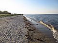
Horseshoe crabs mating in the surf. Slaughter Beach is an official sanctuary for this species.

See also
 In Spanish: Slaughter Beach para niños
