Smith County, Mississippi facts for kids
Quick facts for kids
Smith County
|
|
|---|---|

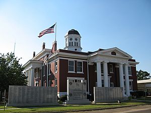
Smith County courthouse in Raleigh
|
|

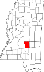
Location within the U.S. state of Mississippi
|
|
 Mississippi's location within the U.S. |
|
| Country | |
| State | |
| Founded | 1833 |
| Named for | David Smith |
| Seat | Raleigh |
| Largest town | Raleigh |
| Area | |
| • Total | 637 sq mi (1,650 km2) |
| • Land | 636 sq mi (1,650 km2) |
| • Water | 1.0 sq mi (3 km2) 0.2% |
| Population
(2010)
|
|
| • Total | 16,491 |
| • Estimate
(2018)
|
16,002 |
| • Density | 25.889/sq mi (9.996/km2) |
| Time zone | UTC−6 (Central) |
| • Summer (DST) | UTC−5 (CDT) |
| Congressional district | 3rd |
Smith County is a county located in the U.S. state of Mississippi. As of the 2010 census, the population was 16,491. Its county seat is Raleigh. Smith County is a prohibition or dry county.
Contents
History
Smith County is named for Major David Smith. The county is well known among Mississippians for its Smith County Watermelons.
Geography
According to the U.S. Census Bureau, the county has a total area of 637 square miles (1,650 km2), of which 636 square miles (1,650 km2) is land and 1.0 square mile (2.6 km2) (0.2%) is water.
Major highways
Adjacent counties
- Scott County (north)
- Jasper County (east)
- Jones County (southeast)
- Covington County (south)
- Simpson County (west)
- Rankin County (northwest)
National protected area
- Bienville National Forest (part)
Demographics
| Historical population | |||
|---|---|---|---|
| Census | Pop. | %± | |
| 1840 | 1,961 | — | |
| 1850 | 4,071 | 107.6% | |
| 1860 | 7,638 | 87.6% | |
| 1870 | 7,126 | −6.7% | |
| 1880 | 8,088 | 13.5% | |
| 1890 | 10,635 | 31.5% | |
| 1900 | 13,055 | 22.8% | |
| 1910 | 16,603 | 27.2% | |
| 1920 | 16,178 | −2.6% | |
| 1930 | 18,405 | 13.8% | |
| 1940 | 19,403 | 5.4% | |
| 1950 | 16,740 | −13.7% | |
| 1960 | 14,303 | −14.6% | |
| 1970 | 13,561 | −5.2% | |
| 1980 | 15,077 | 11.2% | |
| 1990 | 14,798 | −1.9% | |
| 2000 | 16,182 | 9.4% | |
| 2010 | 16,491 | 1.9% | |
| 2018 (est.) | 16,002 | −3.0% | |
| U.S. Decennial Census 1790-1960 1900-1990 1990-2000 2010-2013 |
|||
2020 census
| Race | Num. | Perc. |
|---|---|---|
| White (non-Hispanic) | 10,582 | 74.47% |
| Black or African American (non-Hispanic) | 3,111 | 21.89% |
| Native American | 20 | 0.14% |
| Asian | 19 | 0.13% |
| Other/Mixed | 279 | 1.96% |
| Hispanic or Latino | 198 | 1.39% |
As of the 2020 United States census, there were 14,209 people, 5,820 households, and 4,109 families residing in the county.
Communities
Towns
- Mize
- Raleigh (county seat)
- Taylorsville
- Polkville
Village
Unincorporated communities
- Burns
- Pineville
- Shady Grove
- Summerland
See also
 In Spanish: Condado de Smith (Misisipi) para niños

All content from Kiddle encyclopedia articles (including the article images and facts) can be freely used under Attribution-ShareAlike license, unless stated otherwise. Cite this article:
Smith County, Mississippi Facts for Kids. Kiddle Encyclopedia.
