
Snellville, Georgia facts for kids
Quick facts for kids
Snellville, Georgia
|
|||
|---|---|---|---|
|
City
|
|||

City Hall
|
|||
|
|||
| Motto(s):
"Snellville, Where Everybody's Proud to be Somebody"
|
|||

Location in Gwinnett County and the state of Georgia
|
|||

Snellville, Georgia
Location in Metro Atlanta
|
|||
| Country | United States | ||
| State | Georgia | ||
| County | Gwinnett | ||
| Settled | 1874 | ||
| Incorporated | 1923 | ||
| Government | |||
| • Type | Council-Manager | ||
| Area | |||
| • Total | 10.60 sq mi (27.46 km2) | ||
| • Land | 10.47 sq mi (27.12 km2) | ||
| • Water | 0.13 sq mi (0.34 km2) | ||
| Elevation | 1,062 ft (323.70 m) | ||
| Population
(2020)
|
|||
| • Total | 20,573 | ||
| • Density | 1,964.76/sq mi (758.61/km2) | ||
| Time zone | UTC-5 (EST) | ||
| • Summer (DST) | UTC-4 (EDT) | ||
| ZIP Code(s) |
30078–30039
|
||
| Area code(s) | 770 | ||
| Cell Phone Area Code(s) | 770, 678, 404 | ||
| GNIS feature ID | 0334004 | ||
| Major airport | ATL | ||

Snellville is a city in Gwinnett County, Georgia, United States, east of Atlanta. The population was 18,242 at the 2010 census, and in 2019 the estimated population was 20,077. It is a developed suburb of Atlanta and a part of the Atlanta metropolitan area, and is located roughly 35–40 minutes east of Downtown Atlanta via US-78 and Interstate 285.
Contents
History
English settlers
In 1874 Thomas Snell and James Sawyer, seventeen-year-old friends from London, secretly planned a voyage to the New World. On March 18, James Sawyer and his brother, Charles, left England. However, Snell's parents, having learned of the plan, wouldn't allow him to leave, thus delaying his departure. The Sawyer brothers arrived in New York on April 1, and after a few weeks headed toward Athens, Georgia, and then to Madison County, where they stayed and worked on a farm for $10 a month. Snell did eventually follow his friends to New York and made his way south to meet them. The three then made their way through Jefferson and Lawrenceville. Shortly after Snell's arrival, Charles left for Pennsylvania, later returning to the South and settling in Alabama, where he went into the turpentine business. James had gone also, in search of his brother, leaving Snell to work on the farm of A. A. Dyer.
Unable to find his brother, James Sawyer returned to New York and began work on a farm near the Hudson River area until his 21st birthday in 1878, when he returned to England to claim his inheritance. Shortly following, in August 1879, he returned to Americus, Georgia, and then Gwinnett County. Once in Gwinnett County, Sawyer found Snell in the small settlement then known as New London, near Stone Mountain. In the homestead that Snell now referred to as Snellville, the two built a small wood frame building and started a business together, Snell and Sawyer's Store, similar to the one in which they were employed in London. As was common in small mill towns of the time, they printed store money with the trade value and Snell's likeness on the front that regular customers could use to purchase goods. By the end of 1879, the business was prospering and catering to customers from the neighboring towns of Lawrenceville and Loganville. Travelers would buy supplies at "Snell and Sawyer's" and often spend the night in the nearby oak groves, as the trip was too great for one day's travel. It is uncertain when New London officially became Snellville, but the location of the partners' store was referred to as Snellville in their advertising, and the young town began to show a promising future.
The partnership later dissolved, and Sawyer kept the old store, building granite stone above and around the old frame and then disassembling the wood frame from within. Snell built a new store of granite. In 1883 Sawyer built a home and married Emma Webb, of the historic Snellville Webb family, on November 15. Sawyer opened Snellville's first post office in 1885 and served as postmaster from the back of his store.
Snell died at age 39 in 1896 due to complications following an appendicitis operation. He was buried in Brownlee Mountain, presently known as Nob Hill, and was later reburied in nearby Lithonia.
Initially forced into partial retirement due to failing eyesight, Sawyer later lost his sight completely. After that time the store was owned and operated by various merchants. It was eventually destroyed in 1960 and replaced by a service station. James Sawyer died in 1948 at age 91 and is buried in the Baptist Cemetery (now Snellville Historical Cemetery).
The Snell family remains prominent in the Atlanta area today. Another branch of the family is well established in the Houston area of Texas.
City beginnings
The City of Snellville received its charter from the General Assembly of the State of Georgia in 1923.
In the late 1920s the charter went dormant and remained so for approximately 12 years before it was reorganized in 1940.
Recent times

Snellville's growth remained slow until the 1960s, when the suburban development patterns of segregated uses and automobile dependency became commonplace., and there are fourteen houses of worship located within the city limits.
As of early 2011, new housing construction, much of it upscale, continues in Snellville and in areas of southern Gwinnett County carrying a Snellville address. This is the only area of metro Atlanta where this is occurring on such a large scale, despite the recession. The award-winning and upscale Governor's Walk neighborhood in Snellville went on to be completed after the recession was well under way. Though many of the spec homes in Governor's Walk went into repossession during the recession, all were bought and completed, or were in the process of being completed, as of January 2011. Lake Norris had new upscale construction going on as of January 2011 with two new homes under construction and several major remodelings in progress. There was abundant new construction occurring along Centerville Highway as well, as of January 2011. On Norris Lake Way, a collection of homes in the million dollar range continued to sell as of 2011, making it one of the few areas of the metro where upscale new construction was still selling well.
Hightower Trail and other areas of southern Gwinnett County continue to see new construction as well. New and finished resell homes in Governor's Walk and the Lake Norris area and on acreage in southern Gwinnett County continued to sell strongly during the recession, often for near pre-recession prices. Georgia MLS statistics back this metro Atlanta anomaly, and many feel the area's good luck during the foreclosure crisis occurred because Snellville remained strong economically during the recession, and is a popular relocation area for locals of the metro Atlanta area resettling from other suburban areas.
Snellville Loop
The Snellville Loop (Snellville East-West Connector) concept was developed as a loop road connecting US 78 west of Snellville with GA SR 124 north of Snellville.
On November 9, 1992, the city of Snellville adopted a resolution opposing any loop road around Snellville.
The Atlanta Regional Commission (ARC) then received a request from GDOT and the city of Snellville to conduct a study to identify the best transportation alternatives that are technically sound and supported by the local community. Recognizing the preferred alternative to be a major transportation improvement involving federal funds, ARC and its partners in the planning process designated the study as a Major Investment Study (MIS).
City land swap


In early November 2000, then-mayor Brett Harrell began negotiating a land swap to transform an abandoned supermarket into a municipal complex and the now-former City Hall into part of a church campus. Harrell had campaigned on a platform that included efforts to revitalize vacant retail space.
The project was not without its opponents. Among the concerned were tenants of the half-occupied Oakland Village Shopping Center that the city would take over, and who would be forced to relocate. The City Council voted unanimously that November to proceed with the exploration of a potential land swap. Some citizens expressed concerns about the project at the City Council meeting and asked for the deal to be put to a referendum.
On March 5, 2001, the city held its first public hearing on the land swap. Over 100 citizens attended the meeting to support the idea, while more than a dozen showed up to oppose it. A few cited a recent $79,000 roof job on City Hall, and the fact that the swap would benefit the church more than the city, as reasons to back out of the deal.
On March 26, 2001, the City Council met to vote on the land swap proposal. At this meeting, the citizens were given a few specifics of the deal. According to the Council, the Oakland Village Shopping Center was worth $2,700,000, and the current City Hall was worth $2,300,000. Councilman Jerry Oberholtzer estimated that renovation of the shopping center for city use would be in the $2,500,000 range. He also estimated that to renovate City Hall for future needs would run the city the same cost. More opponents than supporters spoke at the meeting, and a few senior citizens presented a petition against relocating their center which was part of the land swap plan. The City Council voted 3–1 in favor of the swap; Councilman Troy Carter was the only dissenting vote.
As preparation for the swap began, the city hit a snag in June 2001 when it was revealed that there was a possibility of perchloroethylene soil contamination from an old dry cleaner site in the Oakland Village Shopping Center. The Georgia Department of Natural Resources Environmental Protection Division responded that even in the event of contamination, a clean-up may not be required if no one lives close enough to the site or no one is using the ground water in the area. The city did discover the use of a well by a private citizen within a one-mile (1.6 km) radius of the site. This citizen, Harold "Cotton" Willams, refused a $25,000 deal from the Methodist Church to cap the well. In response, the city began exploring a local ordinance banning the construction of new wells and closing any existing ones. The city council voted on June 25 to adopt the ordinance but still allow the use of the well for irrigation. The city council also decided to include the realignment of Oak Road and Henry Clower Boulevard at U.S. 78 in the land swap project.
In July 2001 the land swap hit another snag. A lawyer representing the Nash Family of Snellville filed a lawsuit claiming the city could not trade one of the parcels because the city didn't own it. The Nash family contended it owned the approximately 1-acre (4,000 m2) tract and the unused building sitting on it. In 1935, Horace J. Nash deeded the building to the Georgia Rural Rehabilitation Corporation for use as a vocational center. The building was used to train unemployed workers during and after the Great Depression. Later, the city used the site for a jail, a senior center and an agricultural building. Most recently, the building housed Recorder's Court. Attorney Bill Crecelius said the Nash family had let Snellville use the building for decades without complaint. This issue was resolved when the city presented documents verifying its ownership of the title to the building as well as title insurance.
In July 2003, the last piece of a $6,700,000 building plan for the project fell into place. The Snellville City Council approved funding for a multipurpose complex combining municipal functions and police services, plus offering a public gathering spot. In a 4–2 vote, the council approved certificates of participation, a series of leases that are to be renewed annually until they are paid off in 20 years. The leases, with an interest rate of slightly more than 4 percent, will cost the city about $10 million when they are paid off in two decades. Mayor Brett Harrell, Mayor Pro Tempore Melvin Everson and council members Jerry Oberholtzer and Deborah Rich voted for the funding program. Council members Robert Jenkins and Mike Smith cast dissenting votes. In the final plan, the land swap would include an 8-acre (32,000 m2) project encompassing a new City Hall, police department, senior center and public forum area.
Groundbreaking for the new city hall began in March 2004 with the demolition of the Oakland Village Shopping Center. Hogan Construction Group of Norcross was awarded the $7,400,000 contract to construct both the new City Hall and new Senior Center. The original completion date was pushed back because of poor weather conditions. Crews also had to blast granite under the building foundation, further delaying the project and adding $200,000 to the cost.
On March 12, 2006, the city officially dedicated the new City Hall, located at the corner of Oak Road and Main Street East (US 78). Mayor Jerry Oberholtzer was quoted that arriving at the dedication day took "five years, four elections, three architectural firms and two lawsuits". The city hopes to one day expand the complex by adding a parking deck and a new public safety annex.

On August 13, 2007, the City Council awarded a $52,000 contract to Smithco Construction of Gainesville to demolish and remove the remaining piece of the old Oakland Village Shopping Center. The area has now been converted into an open green space.
Towne Center @ Snellville
In February 2011, the City of Snellville hired engineering firm Clark, Patterson and Lee in conjunction with renowned urban planning firm Duany Plater-Zyberk & Company to begin the process of planning a new town center for the suburban community. A weekend-long design charrette was held to engage the community in the process. The plan that emerged from this visioning process provides a new town green and shopping district, bordered by neighborhoods that incorporate a variety of housing types. The plan takes into account the Continuous Flow Intersection that had previously been planned by the Georgia Department of Transportation. A key element of the new town design is a system of bridges and tunnels that create a more walkable city.
Geography
Snellville is located in southern Gwinnett County at 33°51′30″N 84°0′23″W / 33.85833°N 84.00639°W (33.858439, −84.006324). U.S. Route 78 runs through the center of the city, leading west 25 miles (40 km) to downtown Atlanta and east 19 miles (31 km) to Monroe. Georgia State Route 124 crosses US 78 in the center of Snellville, leading north 7 miles (11 km) to Lawrenceville and south 13 miles (21 km) to Lithonia.
According to the United States Census Bureau, Snellville has a total area of 10.6 square miles (27.4 km2), of which 10.5 square miles (27.1 km2) is land and 0.1 square miles (0.3 km2), or 1.22%, is water.
Climate
Snellville has a humid subtropical climate according to the Köppen classification, with generally hot, humid summers and mild winters by the standards of most of the U.S.
Compared to most large cities around the world at approximately the same latitude (33°39'), such as Beirut, Casablanca, Dallas, Los Angeles, and Phoenix, Snellville has lower average winter temperatures. The primary reason for this is that the North American continent extends into high latitudes that allows systems to form and move eastward and southward without obstruction by major mountain ranges. Other factors include Snellville's distance from large bodies of water; its higher elevation, which can lead to rapid weather changes; prevailing wind patterns; and extensive tree cover, which reduces the urban heat island effect (an advantage during summer).
In the winter, weather systems sweeping south from Canada, through the Midwest, bring temperatures that can reach below 25 °Fahrenheit (−3.9 °Celsius) a few times a year. The lowest temperature recorded in the city is −9 °F (−22 °C), reached on February 13, 1899. It also reached −7 °F (−22 °C) twice and −8 °F (−22 °C) once in Atlanta in the 1980s and 1990s. An average year sees frost on 48 days; snowfall, which occurs most years, averages 2 inches (5 centimeters) annually. The greatest single accumulation of snow was 10 inches (25 centimeters), on January 23, 1940. A more prominent issue in winter are the frequent ice storms that can cause more problems than snow; the most severe such storm may have occurred on January 7, 1973. Also during winter, warm air sometimes flows from the Gulf of Mexico, raising temperatures as high as 75 °F (24 °C).
Though summers are humid, actual temperatures are lower than they may feel, with afternoon highs peaking at about 90 °F (32 °C) in late July. Temperatures rarely reach 100 °F (38 °C), which, during the last 30 years, was recorded in 1980, 1983, 1986, 1993, 1995, 2000, and 2007. The highest temperature recorded in the city is 105 °F (40.6 °C), reached on July 13 and 17, 1980.
Like the rest of the Southeastern U.S., Atlanta experiences abundant rainfall, which is relatively evenly distributed throughout the year. Average annual rainfall is 50.5 inches (127 centimeters); the only other major U.S. cities with greater rainfall are Miami, Florida, and New Orleans, Louisiana.
| Month | Jan | Feb | Mar | Apr | May | Jun | Jul | Aug | Sep | Oct | Nov | Dec | Year |
|---|---|---|---|---|---|---|---|---|---|---|---|---|---|
| Average high °F (°C) | 52 (11) | 57 (14) | 65 (18) | 73 (23) | 80 (27) | 87 (31) | 89 (32) | 88 (31) | 82 (28) | 73 (23) | 63 (17) | 55 (13) | 72 (22) |
| Average low °F (°C) | 34 (1) | 37 (3) | 45 (7) | 50 (10) | 59 (15) | 66 (19) | 72 (22) | 70 (21) | 64 (18) | 54 (12) | 45 (7) | 36 (2) | 52 (11) |
| Average rainfall: inches (millimeters) | 5.03 (127.8) | 4.68 (118.9) | 5.38 (136.7) | 3.62 (91.9) | 3.95 (100.3) | 3.63 (92.2) | 5.12 (130.0) | 3.63 (92.2) | 4.09 (103.9) | 3.11 (79.0) | 4.10 (104.1) | 3.82 (97.0) | 50.16 (1274) |
Parks
Thomas W. Briscoe Park consists of 87 developed acres (100 total acres), just south of the city center on Lenora Church Road. The park hosts numerous activities for youth and seniors including summer camp, swim lessons, soccer and senior trips.
Lenora Park and Disc Golf Course encompasses 112 acres (0.45 km2) of land on Lenora Church Road.
People and culture
Demographics
| Historical population | |||
|---|---|---|---|
| Census | Pop. | %± | |
| 1930 | 105 | — | |
| 1940 | 204 | 94.3% | |
| 1950 | 309 | 51.5% | |
| 1960 | 468 | 51.5% | |
| 1970 | 1,990 | 325.2% | |
| 1980 | 8,514 | 327.8% | |
| 1990 | 12,084 | 41.9% | |
| 2000 | 15,351 | 27.0% | |
| 2010 | 18,242 | 18.8% | |
| 2015 (est.) | 19,733 | 8.2% | |
|
|
|||
As of 2010 Snellville had a population of 18,242. The racial and ethnic composition of the population was 61.0% white, 30.0% black or African American, 0.3% Native American, 1.5% Asian Indian, 0.01% other Asian, 0.1% Pacific Islander, 2.7% from some other race and 2.6% reporting two or more races. 7.4% of the population was Hispanic or Latino of any race.
As of the census of 2000, there were 15,351 people, 5,256 households, and 4,315 families residing in the city. The population density was 1,589.1 people per square mile (613.6/km²). There were 5,391 housing units at an average density of 558.1 per square mile (215.5/km²). The racial makeup of the city was 89.64% White, 5.39% African American, 0.25% Native American, 2.03% Asian, 0.02% Pacific Islander, 1.58% from other races, and 1.09% from two or more races. Hispanic or Latino of any race were 4.09% of the population.
There were 5,256 households out of which 38.2% had children under the age of 18 living with them, 70.3% were married couples living together, 9.0% had a female householder with no husband present, and 17.9% were non-families. 15.0% of all households were made up of individuals and 7.2% had someone living alone who was 65 years of age or older. The average household size was 2.87 and the average family size was 3.18.
In the city, the population was spread out with 26.6% under the age of 18, 7.3% from 18 to 24, 27.4% from 25 to 44, 26.5% from 45 to 64, and 12.3% who were 65 years of age or older. The median age was 39 years. For every 100 females there were 91.5 males. For every 100 females age 18 and over, there were 89.2 males.
The median income for a household in the city was $62,537, and the median income for a family was $68,341. Males had a median income of $52,340 versus $41,587 for females. The per capita income for the city was $26,131. About 2.1% of families and 2.0% of the population were below the poverty line, including 3.3% of those under age 18 and 5.0% of those age 65 or over.
Slogan
In 2010, the city leaders of Snellville voted to adopt a new slogan for the city. The previous slogan, "Snellville, where everybody is somebody," had been established 30 years prior. The current (new) slogan is an evolution of the old and is "Snellville, where everybody is proud to be somebody."
Snellville Days Festival
The Snellville Days Festival is a two-day event held annually that draws crowds from all over the Southeast. The annual celebration is touted as being one of the top 20 tourism events in May according to the Southeastern Tourism Society, but still has a small-town flavor.
Performing arts
The New London Theater group and the Gwinnett Ballet Theatre company both have their roots and studios in Snellville. Triple 7 Dance Company (located where New London Theater used to have its business) is a thriving dance school owned by Tamara Whitehead. Each year the school debuts their Rhapsody Musical, and has been running since 2002.
Snellville in popular culture
- In the 2004 season of American Idol, local resident Diana DeGarmo advanced to the finals.
- In the Broadway Jr. play Roald Dahl's Willy Wonka Jr., Violet Beauregarde and her mother hail from Snellville.
Education
Schools
Public schools
The following schools serve the Snellville area and are part of the Gwinnett County Public Schools:
- Brookwood High School
- Alton C. Crews Middle School
- Brookwood Elementary School
- Craig Elementary School
- Five Forks Middle School
- Gwinn Oaks Elementary School
- R. D. Head Elementary School
- Alton C. Crews Middle School
- Grayson High School
- J. P. McConnell Middle School
- Pharr Elementary School
- W. J. Cooper Elementary School
- Bay Creek Middle School
- Grayson Elementary
- Trip Elementary
- J. P. McConnell Middle School
- Shiloh High School
- Shiloh Middle School
- Anderson-Livsey Elementary School
- Annistown Elementary School
- Centerville Elementary School
- Shiloh Elementary School
- Henry Partee Elementary School
- Shiloh Middle School
- South Gwinnett High School
- Grace Snell Middle School
- J.C. Magill Elementary School
- Rosebud Elementary School
- Snellville Middle School
- R. L. Norton Elementary School
- W. C. Britt Elementary School
- Grace Snell Middle School
Private schools
- Evergreen Montessori School
- Gwinnett Christian Academy, grades K5–12
- Harbour Oaks Montessori School, grades K2–12
Public libraries
Gwinnett County Public Library operates the Elizabeth H. Williams Branch in Snellville.
Infrastructure
Transportation
Major roads
|
-
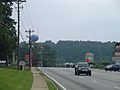
U.S. 78 looking west toward the city center
-
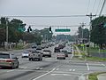
U.S. 78 looking east from the city center toward Loganville
-

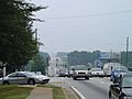
State Route 124 looking south toward the city center from Dogwood Road
-
State Route 124 looking north toward Lawrenceville from Dogwood Road


Pedestrians and cycling
- Ivy Creek-Snellville Trail (Proposed)
Public transportation

Route 418 of the Xpress bus service, a joint venture between Gwinnett County Transit and the Georgia Regional Transportation Authority (GRTA), provides commuter bus service to downtown Atlanta from Snellville in the morning, and vice versa in the afternoon. Seven departure times are available in the morning and seven in the afternoon, Monday-Friday, via Stone Mountain Freeway (U.S. 78) to I-285 and I-20. The morning westbound route terminates at the Civic Center MARTA Station. The afternoon eastbound route terminates at the First Baptist Church of Snellville, with a stop at the Hewatt Road Park&Ride.
Gwinnett County Transit is also testing a mirco-transit service in the Snellville area.
History
Buses first ran on the morning of April 2, 2007. In that first month, the route had a total of 1,783 riders. In May, there was a 40% increase to 2,520. On many mornings, the bus is standing room only. On August 21, 2007, the Gwinnett County Board of Commissioners approved an agreement with GRTA to add five new Motor Coach Industries D4500CL buses to the route.
Medical centers
Snellville has one major hospital, Eastside Medical Center, formerly Emory Eastside Medical Center, which serves the southern Gwinnett County Region.
Media
Newspapers
- Atlanta Journal-Constitution (major regional paper)
- Gwinnett Daily Post
Radio
Television
Notable people
- 21 Savage, rapper, stayed in Snellville in his late teens before returning to DeKalb County
- Matt Beaty, baseball player
- Ben Bledsoe, musician
- Clay Cook, singer/songwriter, member of the Zac Brown Band, writer of songs for John Mayer; was influential in getting Mayer to originally move to Atlanta
- Rennie Curran, football player, linebacker , Tennessee Titans
- Diana DeGarmo, 2004 American Idol runner-up
- Jason Elam, former football player, kicker, Atlanta Falcons
- Joe Gebbia , co-founder of Airbnb.com
- David Greene, football player, quarterback, New England Patriots
- Sean Johnson , current goalie for the MLS soccer team Chicago Fire
- Michael Kelly , Emmy award-nominated actor in The Sopranos, The Changeling, Person of Interest and House of Cards
- Aaron Keyes, Christian musician
- Jon Langston , country music singer
- Kyle Lewis , baseball player
- Mike Mercer, basketball player, guard, University of South Florida
- Josh Okogie, professional basketball player for the Minnesota Timberwolves
- Melissa Ordway, actress; plays Abby Newman on The Young and the Restless
- David Pollack, football player, defensive end, Cincinnati Bengals
- Amy Robach , Good Morning America news anchor
- Nakia Sanford (1995), former forward/center in the WNBA
- Eric Shanteau, member of USA swim team, 2008 Summer Olympics
- Sound Tribe Sector 9, band now located in the Bay Area of California
- Amanda Weir, swimmer, Olympic medalist, 2004 Summer Olympics
- Lou Williams, basketball player, guard, Atlanta Hawks
See also
 In Spanish: Snellville para niños
