
Snowtown, South Australia facts for kids
Quick facts for kids SnowtownSouth Australia |
|||||||||||||||
|---|---|---|---|---|---|---|---|---|---|---|---|---|---|---|---|

South-western entrance to Snowtown
|
|||||||||||||||

Snowtown
Location in South Australia
|
|||||||||||||||
| Population |
|
||||||||||||||
| Established | 1878 | ||||||||||||||
| Postcode(s) | 5520 | ||||||||||||||
| Elevation | 103 m (338 ft) | ||||||||||||||
| Location | 145 km (90 mi) north of Adelaide | ||||||||||||||
| LGA(s) | Wakefield Regional Council | ||||||||||||||
| County | Daly | ||||||||||||||
| State electorate(s) | Narungga | ||||||||||||||
| Federal Division(s) | Grey | ||||||||||||||
|
|||||||||||||||
|
|||||||||||||||
Snowtown is a town located in the Mid North of South Australia 145 km (90 miles) north of Adelaide and lies on the main road and rail routes between Adelaide and Perth – the Augusta Highway and Adelaide-Port Augusta railway line. The town's elevation is 103 metres (338 feet) and on average the town receives 389 mm of rainfall per annum.
Contents
History
The settlement of Snowtown by non-indigenous Australians initially grew up around a railway station on the Brinkworth-Wallaroo line. Located on what was traditionally the land of the Kaurna (indigenous) people, the first pioneers arrived sometime between 1867 and 1869 due to the rapid expansion of farming to the north of the area. During this period one of the first major structures, the old Snowtown Pub was built in 1868. north of Port Wakefield. This farmland, according to the publication, contained the farming stations of Barunga, Bumbunga and Wokurna and consisted of "salt lakes and lagoons, dense scrub, with mallee, pine and bushes, grassy plains and saltbush, well grassed spurs and hills, with oaks and wattle on the Broughton River."
The Government only started showing interest in the settlement as late as 1869 when it planned to establish various new towns throughout the district and to divide the land into much smaller holdings. Snowtown's charter was formally proclaimed by the then Governor of South Australia, Sir William Jervois, in 1878. Jervois named the town after one of the members of the Snow family who were his cousins and lived on Yorke Peninsula (which lies immediately west and southwest of Snowtown). It is officially considered that the town was named after Thomas Snow, who became Jervois's aide de camp when he received his posting in South Australia.
Bumbunga Province
During the 1970s and 1980s, the secessionist micronation of Bumbunga Province existed on farmland owned by the Brackstone family, 15 kilometres (9.3 mi) south of Snowtown.
Geography and climate
Snowtown is situated approximately 7 kilometres east of Barunga Gap, South Australia, a cleft between the Barunga and Hummocks ranges. The excess rainfall from these hills collects in Lake Bumbunga, directly south of the township, and in a trail of smaller lakes stretching north of the town to Lake View near the main highway and railway line. Beyond the eastern edge of the township is the Snowtown Golf Course and a swampy region populated by saltbush and other salt-tolerant flora.
Snowtown has a warm Mediterranean climate with average summer temperatures around 30 °C and winter temperatures around 16 °C. The average annual rainfall is 407.4 millimetres (16.04 in), most of which falls in the winter months.
| Climate data for Snowtown | |||||||||||||
|---|---|---|---|---|---|---|---|---|---|---|---|---|---|
| Month | Jan | Feb | Mar | Apr | May | Jun | Jul | Aug | Sep | Oct | Nov | Dec | Year |
| Record high °C (°F) | 46.3 (115.3) |
44.6 (112.3) |
43.0 (109.4) |
39.6 (103.3) |
31.7 (89.1) |
26.7 (80.1) |
27.7 (81.9) |
30.3 (86.5) |
34.4 (93.9) |
40.0 (104.0) |
43.9 (111.0) |
45.0 (113.0) |
46.3 (115.3) |
| Average high °C (°F) | 31.1 (88.0) |
30.8 (87.4) |
28.6 (83.5) |
23.6 (74.5) |
19.4 (66.9) |
16.2 (61.2) |
15.4 (59.7) |
16.7 (62.1) |
19.7 (67.5) |
23.2 (73.8) |
26.7 (80.1) |
29.2 (84.6) |
23.3 (73.9) |
| Average low °C (°F) | 14.6 (58.3) |
14.7 (58.5) |
12.7 (54.9) |
9.9 (49.8) |
7.8 (46.0) |
6.0 (42.8) |
5.2 (41.4) |
5.6 (42.1) |
6.7 (44.1) |
8.6 (47.5) |
11.1 (52.0) |
13.2 (55.8) |
9.7 (49.5) |
| Record low °C (°F) | 3.8 (38.8) |
2.8 (37.0) |
0.0 (32.0) |
−1.1 (30.0) |
−2.0 (28.4) |
−3.9 (25.0) |
−4.4 (24.1) |
−3.1 (26.4) |
−2.2 (28.0) |
−1.7 (28.9) |
0.6 (33.1) |
2.2 (36.0) |
−4.4 (24.1) |
| Average rainfall mm (inches) | 18.6 (0.73) |
19.0 (0.75) |
17.3 (0.68) |
29.8 (1.17) |
44.4 (1.75) |
52.4 (2.06) |
49.7 (1.96) |
50.2 (1.98) |
43.2 (1.70) |
37.6 (1.48) |
24.8 (0.98) |
20.4 (0.80) |
407.4 (16.04) |
| Average rainy days (≥ 0.2mm) | 3.5 | 3.4 | 4.0 | 7.0 | 10.4 | 12.5 | 13.4 | 13.5 | 10.9 | 9.2 | 6.0 | 4.7 | 98.5 |
| Source: Bureau of Meteorology | |||||||||||||
Built environs

The town's main street, Fourth Street contains most of the town's civic buildings, notably the Snowtown Memorial Hall (built 1919) which is attached to the Old Institute (built 1889).
In 2008, a monument in the form of a 44-metre wind turbine blade was installed at the intersection of Fourth Street and Railway Terrace East.
Transport
The main north-south road running just outside the western edge of the town was designated to form part of Australia's Highway 1 in 1955.
The Brinkworth–Kadina railway line opened in 1879.
The Salisbury-Redhill broad railway gauge line was opened in 1925 and intersected the town along a north-south axis. In 1982 the line was converted to standard gauge, making it a part of the Adelaide-Port Augusta railway line.
School
In 1879 Mrs Lamb opened a Provisional School in Snowtown with a total enrolment of 14 pupils. During its lifetime agricultural science has been a particular focus for the school.
In 1961 the school became an area school known as Snowtown Area School and was located on 4.5 hectares (11 acres) of land, with an additional 10 hectares (25 acres) of land used for agricultural studies.
In the 1970s and 1980s, the school's respected agricultural credentials drew students from neighbouring communities. The school provided many entries into Royal Adelaide Show livestock and horticulture competitions, especially the sheep and beef cattle categories. In the early 1980s the school became a poll dorset sheep stud called 'SASdor' for several years.
Pupil enrolments at Snowtown Area School in 2006 totalled 118, with many pupils also travelling from nearby Lochiel, Barunga Gap and Redhill. pupils were also able to study via distance education through the Open Access College at Marden (Adelaide) or via larger neighbouring schools to increase their range of subject choices.
By 2012, the fall in enrolments, and consequent drop in funding, led to the ceasing of senior enrolments at the commencement of the 2013 school year. The school was subsequently renamed to Snowtown Primary School.
In 2015, pupil enrolments at Snowtown Primary School totalled 52.
Economy

Located in what is described as a wheat-belt, the local Snowtown economy is predominantly based on cereal crops. Other primary industries include woolgrowing, livestock production and salt mining (at the nearby Lake Bumbunga saltworks).
Snowtown is a service centre for the local area, providing various essential services for the district as well as for motorists on the Augusta Highway, the section of Highway 1 past the town.
In 2008, TrustPower completed the first stage of the 47-turbine Snowtown Wind Farm in the Barunga and Hummocks ranges just west of Snowtown. The wind turbines are 110 metres from the ground to tip of the top wing. Snowtown Wind Farm 2 is one of the most modern wind farms in Australia. This wind farm produces enough electricity for 180,000 South Australian homes; the 270MW Snowtown 2 Wind Farm was commissioned in October 2014, producing an average of 875GWh of electricity per year.
Notable residents
- Australian cricketer Lauren Ebsary was born and schooled in Snowtown.
Images for kids
-
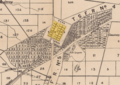
Town boundaries as shown on an 1880 map of the Hundred of Barunga
-
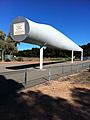
Big blade, Snowtown


