
SoHo, Manhattan facts for kids
Quick facts for kids
SoHo
|
|
|---|---|

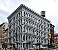
Cast-iron buildings on Grand Street between Lafayette Street and Broadway
|
|
| Country | |
| State | |
| City | New York City |
| Borough | Manhattan |
| Community District | Manhattan 2 |
| Area | |
| • Total | 0.87 km2 (0.336 sq mi) |
| Population
(2019)
|
|
| • Total | 18,894 |
| • Density | 21,710/km2 (56,230/sq mi) |
| Economics | |
| • Median income | $135,083 |
| Time zone | UTC−5 (Eastern) |
| • Summer (DST) | UTC−4 (EDT) |
| ZIP codes |
10012, 10013
|
| Area code | 212, 332, 646, and 917 |
|
SoHo–Cast Iron Historic District
|
|

Location in Manhattan

Location in New York City
|
|
| Location | Roughly north to south: Houston to Canal Streets; and west to east: West Broadway or Sixth Avenue to Crosby Street or Lafayette Street Manhattan, New York City |
| Area | 73 acres (30 ha) |
| Architectural style | Renaissance Italianate some Federal |
| NRHP reference No. | 78001883 |
| Significant dates | |
| Added to NRHP | June 29, 1978 |
SoHo, sometimes written Soho, is a neighborhood in Lower Manhattan in New York City. Since the 20th century it has been the location of many artists' lofts and art galleries, and has also been known for its variety of shops ranging from trendy upscale boutiques to national and international chain store outlets. The area's history is an archetypal example of inner-city regeneration and gentrification, encompassing socioeconomic, cultural, political, and architectural developments.
The name "SoHo" derives from the area being "South of Houston Street", and was coined in 1962 by Chester Rapkin, an urban planner and author of The South Houston Industrial Area study, also known as the "Rapkin Report". The name also recalls Soho, an area in London's West End.
Almost all of SoHo is included in the SoHo–Cast Iron Historic District, which was designated by the New York City Landmarks Preservation Commission in 1973, extended in 2010, and was listed on the National Register of Historic Places and declared a National Historic Landmark in 1978. It consists of 26 blocks and approximately 500 buildings, many of them incorporating cast-iron architectural elements. Many side streets in the district are paved with Belgian blocks.
SoHo is part of Manhattan Community District 2 and its primary ZIP Codes are 10012 and 10013. It is patrolled by the 1st and 5th Precincts of the New York City Police Department.
Contents
Geography
Boundaries
SoHo is bounded by Houston Street on the northern side, Canal Street on the south, Crosby Street on the east, and Sixth Avenue to the west, according to The Encyclopedia of New York City. The AIA Guide to New York City gives the western boundary of SoHo north of Broome Street as West Broadway.
In the 1990s, real estate agents began giving an adjacent neighborhood below West Houston Street various appellations, with no general agreement on whether it should be called West SoHo, Hudson Square or the South Village. The AIA Guide calls that neighborhood "An intersection of brick and glass, searching for an identity," and refers to the western section of it as "The Glass Box District".


Historic District
The SoHo-Cast Iron Historic District is contained within the zoned SoHo neighborhood. Originally ending in the west at the eastern side of West Broadway and to the east at the western side of Crosby Street, the SoHo-Cast Iron Historic District was expanded in 2010 to cover most of West Broadway and to extend east to Lafayette and Centre Streets. The boundary lines are not straight, and some block-fronts on West Broadway and Lafayette are excluded from the District.
History
Early years
During the colonial period, the land that is now SoHo was part of a grant of farmland given to freed slaves of the Dutch West Indies Company, and the site of the first free Black settlement on Manhattan island. This land was acquired in the 1660s by Augustine Hermann, and then passed to his brother-in-law, Nicholas Bayard. The estate was confiscated by the state as a result of Bayard's part in Leisler's Rebellion, but was returned to him after the sentence was annulled.
In the 18th century natural barriers – streams and hills – impeded the growth of the city northward into the Bayard estate, and the area maintained its rural character. During the American Revolution, the area was the location of numerous fortifications, redoubts and breastworks. After the war, Bayard, who had suffered financially because of it, was forced to mortgage some of the property, which was divided up into lots, but even then there was very little development in the area, aside from some manufacturing at Broadway and Canal Street.
Serious development of the area did not begin until the Common Council, answering the complaints of landowners in the area, drained the Collect Pond, which had once been an important source of fresh water for the island, but which had become polluted and rank and a breeding ground for mosquitoes. A canal was built to drain the pond into the Hudson, and the canal and pond were both later filled in using earth from nearby Bayard's Hill. Once Broadway was paved and sidewalks were built there and along Canal Street, more people began to make their homes there, joining earlier arrivals such as James Fennimore Cooper.
Commerce, entertainment, and decline
By the mid-19th century, the early Federal- and Greek Revival-style homes were replaced by more-solid structures of masonry and cast iron, and along Broadway, large marble-skinned commercial establishments began to open, such as Lord & Taylor, Arnold Constable & Company and Tiffany & Company, as well as grand hotels such as the St. Nicholas and the Metropolitan. Theatres followed in their wake, and Broadway between Canal and Houston Streets became a lively theater and shopping district and the entertainment center of New York. Small manufacturing businesses were made, including cabinet-makers and the lumberyards that supplied them, brass and copper firms, makers of china and glassware, locksmiths, snuff manufacturers and book publishers.
This dramatic shift in the nature of the neighborhood continued to drive out residents, and between 1860 and 1865 the Eighth Ward, which included the SoHo area, lost 25% of its population. After the Civil War and the Panic of 1873, in the 1880s and 90s, large manufacturers began to move into the area, especially textile firms, and the area became the mercantile and wholesale dry-goods trade center of the city, and was the subject of significant real-estate speculation. This phase came to an end by the close of the 19th century, and as the center of the city continued to move uptown, the quality of the area declined.
After World War II, the textile industry largely moved to the South, leaving many large buildings in the district unoccupied. In some buildings they were replaced by warehouses and printing plants, and other buildings were torn down to be replaced by gas stations, auto repair shops and parking lots and garages. By the 1950s, the area had become known as Hell's Hundred Acres, an industrial wasteland, full of sweatshops and small factories in the daytime, but empty at night. It would not be until the 1960s, when artists began to be interested in the tall ceilings and many windows of the empty manufacturing lofts, that the character of the neighborhood began to change again.
Cast-iron architecture
SoHo boasts the greatest collection of cast-iron architecture in the world. Approximately 250 cast-iron buildings stand in New York City and the majority of them are in SoHo. Cast iron was initially used as a decorative front over a pre-existing building. With the addition of modern, decorative facades, older industrial buildings were able to attract new commercial clients. Most of these facades were constructed during the period from 1840 to 1880. In addition to revitalizing older structures, buildings in SoHo were later designed to feature the cast iron.

An American architectural innovation, cast iron was cheaper to use for facades than materials such as stone or brick. Molds of ornamentation, prefabricated in foundries, were used interchangeably for many buildings, and a broken piece could be easily recast. The buildings could be erected quickly; some were built in four months. Despite the brief construction period, the quality of the cast-iron designs was not sacrificed. Bronze had previously been the metal most frequently used for architectural detail. Architects found that the relatively inexpensive cast iron could provide intricately designed patterns. Classical French and Italian architectural designs were often used as models for these facades. Because stone was the material associated with architectural masterpieces, cast iron, painted in neutral tints such as beige, was used to simulate stone.
There was a profusion of cast iron foundries in New York, including Badger's Architectural Iron Works, James L. Jackson's Iron Works, and Cornell Iron Works.
Since the iron was pliable and easily molded, sumptuously curved window frames were created, and the strength of the metal allowed these frames considerable height. The once-somber, gas-lit interiors of the industrial district were flooded with sunlight through the enlarged windows. The strength of cast iron permitted high ceilings with sleek supporting columns, and interiors became expansive and functional.
During cast iron's heyday, many architects thought it to be structurally more sound than steel. It was also thought that cast iron would be fire-resistant, and facades were constructed over many interiors built of wood and other flammable materials. When exposed to heat, cast iron buckled, and later cracked under the cold water used to extinguish fire. In 1899, a building code mandating the backing of cast-iron fronts with masonry was passed. Most of the buildings that stand today are constructed in this way. It was the advent of steel as a major construction material that brought an end to the cast iron era.
Lower Manhattan Expressway
In the 1960s, the SoHo area was to have been the location of two enormous elevated highways that comprised the two branches of the Lower Manhattan Expressway, a Robert Moses project that was intended to create an automobile and truck through-route connecting the Manhattan Bridge and Williamsburg Bridge on the east with the Holland Tunnel on the west.
The young historic preservation movement and architectural critics, stung by the destruction of the original Pennsylvania Station in 1963 and the threat to other historic structures, challenged the plans because of the threatened loss of a huge quantity of 19th-century cast-iron buildings, which were not highly valued by the general public or the business community at the time.

When John V. Lindsay became mayor of New York City in 1966, his initial reaction was to try to push the expressways through, dubbing the project the Lower Manhattan Expressway, depressing some of the proposed highway in residential areas and stressing the importance of the artery to the city. Nevertheless, through the efforts of Jane Jacobs, Tony D'Apolito, and other local, civic, and cultural leaders, as well as SoHo artist residents themselves, the project was derailed.
Artists move in
After the abandonment of the highway scheme, the city was left with a large number of historic buildings that were unattractive for the kinds of manufacturing and commerce that survived in the city in the 1970s. The upper floors of many of these buildings had been built as commercial Manhattan lofts, which provided large, unobstructed spaces for manufacturing and other industrial uses. These spaces attracted artists who valued them for their large areas, large windows admitting natural light and low rents. Most of these spaces were also used illegally as living space, despite being neither zoned nor equipped for residential use. This widespread zoning violation was ignored for a long period of time, as the artist-occupants were using space for which there was little demand due to the city's poor economy at the time, and would have lain dormant or been abandoned otherwise.

Nevertheless, as the artist population grew, the city made some attempts to stem the movement, concerned about the occupation of space that did not meet residential building codes, and the possibility that the occupied space might be needed for the return of manufacturing to New York City. Pressured on many sides, the city abandoned attempts to keep the district as strictly industrial space, and in 1971, the Zoning Resolution was amended to permit Joint Live-Work Quarters for artists, and the M1-5a and M-5b districting was established to permit visual artists, certified as such by the Department of Cultural Affairs, to live where they worked.
The area received landmark designation as the SoHo-Cast Iron Historic District in 1973.

Gentrification and shopping
In 2005, the construction of residential buildings on empty lots in the historic district was permitted. Nevertheless, with no enforcement of the new zoning laws by the city, beginning in the 1980s, in a way that would later apply elsewhere, the neighborhood began to draw more affluent residents. Due to rent protection and stability afforded by the 1982 Loft Law, in addition to the fact that many of the artists owned their co-ops, many of the original pioneering artists remained despite the popular misconception that gentrification forced them to flee. Many residents have lived in the neighborhood for decades. In the mid-1990s, most of the galleries moved to Chelsea, but several galleries remain as of 2013, including William Bennett Gallery, Martin Lawrence Galleries, Terrain Gallery, Franklin Bowles Gallery, and Pop International Gallery.
SoHo's location, the appeal of lofts as living spaces, its architecture, and its reputation as a haven for artists all contributed to this change. The pattern of gentrification is typically known as the "SoHo Effect" and has been observed elsewhere in the United States. A backwater of poor artists and small factories in the 1970s, SoHo became a popular tourist destination for people seeking fashionable clothing and exquisite architecture, and home to some of the most expensive real estate in the country.
SoHo's chain outlets are clustered in the northern area of the neighborhood, along Broadway and Prince and Spring Streets. The sidewalks in this area are often crowded with tourists and with vendors selling jewelry, T-shirts, and other works. SoHo is known for its commercialization and eclectic mix of boutiques for shopping. Although in 2010, it had twice as many chain stores as boutiques and three times as many boutiques as art galleries.
Transportation
SoHo can be reached by the New York City Subway, using the A, C, and E train to Spring Street; 1 and 2 train to Houston Street; the N, Q, R, and W train to Prince Street; and the 4, 6 <6> trains to Spring Street. The crosstown M21 on Houston Street and the north-south M1, M55 bus routes also serve the neighborhood.
Demographics
For census purposes, the New York City government classifies SoHo as part of a larger neighborhood tabulation area called SoHo-TriBeCa-Civic Center-Little Italy. Based on data from the 2010 United States Census, the population of SoHo-TriBeCa-Civic Center-Little Italy was 42,742, a change of 5,985 (14%) from the 36,757 counted in 2000. Covering an area of 581.62 acres (235.37 ha), the neighborhood had a population density of 73.5 inhabitants per acre (47,000/sq mi; 18,200/km2). The racial makeup of the neighborhood was 66.1% (28,250) White, 2.2% (934) African American, 0.1% (30) Native American, 22.2% (9,478) Asian, 0% (11) Pacific Islander, 0.4% (171) from other races, and 2.6% (1,098) from two or more races. Hispanic or Latino of any race were 6.5% (2,770) of the population.
The entirety of Community District 2, which comprises SoHo and Greenwich Village, had 91,638 inhabitants as of NYC Health's 2018 Community Health Profile, with an average life expectancy of 85.8 years. This is higher than the median life expectancy of 81.2 for all New York City neighborhoods. Most inhabitants are adults: a plurality (42%) are between the ages of 25–44, while 24% are between 45–64, and 15% are 65 or older. The ratio of youth and college-aged residents was lower, at 9% and 10% respectively.
As of 2017, the median household income in Community Districts 1 and 2 (including the Financial District and Tribeca) was $144,878, though the median income in SoHo individually was $124,396. In 2018, an estimated 9% of SoHo and Greenwich Village residents lived in poverty, compared to 20% in all of Manhattan and 20% in all of New York City. One in twenty-five residents (4%) were unemployed, compared to 7% in Manhattan and 9% in New York City. Rent burden, or the percentage of residents who have difficulty paying their rent, is 38% in SoHo and Greenwich Village, compared to the boroughwide and citywide rates of 45% and 51% respectively. Based on this calculation, as of 2018[update], SoHo and Greenwich Village are considered high-income relative to the rest of the city and not gentrifying.

Education
_14_-_Chelsea_HS.jpg)
SoHo and Greenwich Village generally have a higher rate of college-educated residents than the rest of the city. The vast majority of residents age 25 and older (84%) have a college education or higher, while 4% have less than a high school education and 12% are high school graduates or have some college education. By contrast, 64% of Manhattan residents and 43% of city residents have a college education or higher. The percentage of SoHo and Greenwich Village students excelling in math rose from 61% in 2000 to 80% in 2011, and reading achievement increased from 66% to 68% during the same time period.
SoHo and Greenwich Village's rate of elementary school student absenteeism is lower than the rest of New York City. In SoHo and Greenwich Village, 7% of elementary school students missed twenty or more days per school year, less than the citywide average of 20%. Additionally, 91% of high school students in SoHo and Greenwich Village graduate on time, more than the citywide average of 75%.
Schools
There are no New York City Department of Education schools in SoHo, although there are several just outside its borders, including:
- Broome Street Academy Charter School (M522, 121 Avenue of the Americas)
- Chelsea Career & Technical Education High School (M615, 131 Avenue of the Americas)
- NYC Ischool (M376, 131 Avenue of the Americas)
- P.S. 130 Hernando de Soto School (M130, 143 Baxter Street)
- Unity Center for Urban Technologies (M500, 121 Avenue of the Americas)
The Montessori School in SoHo is at 75 Sullivan Street.
Library
The New York Public Library's Mulberry Street branch at 10 Jersey Street. The library occupies three floors of a former chocolate factory in SoHo, including two basement levels.
Images for kids
-
The E. V. Haughwout Building at Broadway and Broome Street was built in 1856–57, and has a cast-iron facade by Daniel D. Badger
-
Cast-iron architecture on Broome Street
.JPG)

See also
 In Spanish: SoHo (Nueva York) para niños
