
South Brisbane, Queensland facts for kids
Quick facts for kids South BrisbaneBrisbane, Queensland |
|||||||||||||||
|---|---|---|---|---|---|---|---|---|---|---|---|---|---|---|---|
     (From left to right)
Night view of South Brisbane Streets Beach in South Bank Parklands, Fish Lane, Merivale Bridge viaduct art, South Brisbane railway station |
|||||||||||||||

South Brisbane
Location in Queensland
|
|||||||||||||||
| Population | 7,196 (2016 census) | ||||||||||||||
| • Density | 3,130/km2 (8,100/sq mi) | ||||||||||||||
| Postcode(s) | 4101 | ||||||||||||||
| Area | 2.3 km2 (0.9 sq mi) | ||||||||||||||
| Time zone | AEST (UTC+10:00) | ||||||||||||||
| Location | 1.6 km (1 mi) SW of Brisbane GPO | ||||||||||||||
| LGA(s) | City of Brisbane (The Gabba Ward) | ||||||||||||||
| State electorate(s) | South Brisbane | ||||||||||||||
| Federal Division(s) | Griffith | ||||||||||||||
|
|||||||||||||||
South Brisbane is an inner southern suburb in the City of Brisbane, Queensland, Australia. In the 2016 census, South Brisbane had a population of 7,196 people.
Contents
Demographics
In the 2011 census the population of South Brisbane was 5,416, 48.8% female and 51.2% male. The median age of the South Brisbane population was 30 years, seven years below the Australian median. One-third of the population (33.3%) were aged in their twenties, compared to 13.8% nationally. 44.2% of people living in South Brisbane were born in Australia, compared to the national average of 69.8%. The other top responses for country of birth were England 3.8%, New Zealand 3.7%, China 3.3%, Korea, Republic of 3%, India 2%. 57.2% of people spoke only English at home; the next most popular languages were 5.5% Mandarin, 2.8% Korean, 2.7% Cantonese, 2.1% Greek, 1.9% Arabic. The most common religious affiliation was "No Religion" (30%); the next most common responses were Catholic (19%), Anglican (8.5%), Buddhism (4.6%) and Islam (3.8%).
History


Known, along with West End and Highgate Hill as Kurilpa (Water Rat) to the local indigenous people, the area remains important in indigenous life. Musgrave Park has been for many years a place of congregation for the Murri peoples of south-east Queensland. It is the site of a bora ring that has been buried.
European settlement commenced with the first land sales in 1843, followed by the development of wharves along the bank of the Brisbane River. Commercials buildings and hotels developed around the Russell Street area. By the 1850s there were over 100 residences in the area.
South Brisbane Recreation Reserve (now known as Musgrave Park) was created in 1856.
In 1867, it was proposed to build a public grammar school adjacent to the reserve. However it was not until 1925 that Brisbane State High School moved to the site (having first been established in 1921 at old Normal School on the corner of Adelaide and Edward Street)
In 1884, the railway to the south was opened with a terminus at South Brisbane. As a result, South Brisbane experienced a construction boom.
In 1888, South Brisbane became an independent municipality, initially as the Borough of South Brisbane and then becoming the City of South Brisbane in 1903. In 1925 the City of South Brisbane was amalgamated into the City of Greater Brisbane.
The first electric tramway in Brisbane ran along Stanley Street in South Brisbane on 16 June 1897.

The South Brisbane Memorial Park commemorates those of South Brisbane who died in World War I. On 20 May 1921 the South Brisbane City Council set aside a triangular block land bounded by Stanley Street, Vulture Street and Sidon Street opposite the South Brisbane Town Hall. On 6 August 1923 the park was dedicated Governor-General of Australia, Henry Forster.
The suburb was previously heavily industrialised. Its regeneration began when it was selected as the location of World Expo '88, which was built on former wharves and industrial land. Following Expo '88, South Bank Parklands was built on the former Expo site. South Brisbane has emerged as fashionable, high density, modern residential area, given its proximity to the city centre and good public transport links.
Heritage listings
Being one of the older parts of Brisbane and an area of greater cultural heritage, South Brisbane has a number of heritage-listed buildings:
- South Bank Parklands: Allgas Building
- South Bank Parklands: Byanda
- South Bank Parklands: Nepal Peace Pagoda
- South Bank Parklands: Plough Inn
- 38 Dorchester Street: Coorooman
- Grey Street: William Jolly Bridge
- 133 Grey Street: South Brisbane railway station
- 39 Melbourne Street: Queensland National Bank
- 20 Merivale Street: St. Mary's Catholic Church
- 88 Merivale Street: Brisbane South Girls and Infants School
- 46 Montague Road: Coronation Hotel
- 74 Stanley Street: Victoria Bridge Abutment
- 412 Stanley Street: South Brisbane Dry Dock
- 412 Stanley Street: South Brisbane Railway Easement
- 472 Stanley Street: South Brisbane Library
- 160 Vulture Street: St Andrew's Anglican Church
- 253 Vulture Street: Cumbooquepa
- 263 Vulture Street: South Brisbane Town Hall
In addition, the Richard Randall Art Studio used to be located in South Brisbane, but it was relocated to Toowong in 2007.
South Bank

The South Bank precinct in South Brisbane contains many notable attractions.
South Bank Parklands
The South Bank Parklands are one of Brisbane's most popular tourist attractions. The parklands are home to many restaurants and café's as well as landmarks such as the Queensland Conservatorium, the Wheel of Brisbane, the Nepal Peace Pagoda, Streets Beach, and the Grand Arbour. Approximately 11,000,000 people visit the South Bank Parklands each year.
Grey Street and Little Stanley Street

A number of Brisbane's most popular restaurants and fashion boutiques are located on Grey Street, and Little Stanley Street which it runs parallel to. The South Bank Cinemas are also located on Grey Street, along with two five star hotels.
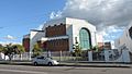
Brisbane Convention & Exhibition Centre

The Brisbane Convention & Exhibition Centre contains 24 meeting and event spaces including four exhibition halls with a combined area of 20,000m² and an auditorium capable of seating 8,000. The venue has received 107 industry awards, making it the most awarded convention centre in Australia. The centre has also been ranked among the top three convention centres world-wide by the Association Internationale des Palais de Congres (AIPC).
Queensland Maritime Museum
The Queensland Maritime Museum is located next to the Goodwill Bridge at the southern end of the South Bank Parklands. It houses a two level exhibition building, a library, a dry dock, a lighthouse and several retired vessels.
Queensland Cultural Centre

The Queensland Cultural Centre consists of:
- The Queensland Performing Arts Centre,
- The Queensland Museum and Science Centre,
- The Queensland Art Gallery,
- The Queensland Gallery of Modern Art,
- The State Library of Queensland
Griffith University
The South Bank campus of Griffith University includes the Queensland Conservatorium and the Queensland College of Art and the Griffith Film School.
Southbank Institute of Technology
The Southbank Institute of Technology spreads over several blocks between the railway line and Merivale Street.
Business
Mater Health Services provides a wide range of public and private medical services in the area to the south of the suburb around Mater Hill and close to its border with Woolloongabba.
A number of major corporations have recently established offices in new buildings along Grey Street and Melbourne Street.
Education
Somerville House is a private primary and secondary (Prep-12) school for girls at 17 Graham Street (27°29′01″S 153°01′31″E / 27.4836°S 153.0254°E). In 2018, the school had an enrolment of 1317 students with 125 teachers (117 full-time equivalent) and 102 non-teaching staff (90 full-time equivalent).
Lady Cilento Children's Hospital School is a specific-purpose primary and secondary (Prep-12) school at Raymond terrace (27°29′04″S 153°01′38″E / 27.4844°S 153.0272°E). It provides schooling to children being treated in the hospital and also for other children in the family whose schooling has been disrupted by the hospitalisation and to assist in their transition to/from their regular school. In 2019, the school had an enrolment of 3,567 students across all of its campuses with 42 teachers (34 full-time equivalent) and 24 non-teaching staff (15 full-time equivalent).
St Laurence's College is a Catholic primary and secondary (5-12) school for boys at 82 Stephens Road (27°29′09″S 153°01′26″E / 27.4859°S 153.0240°E). In 2018, the school had an enrolment of 1890 students with 149 teachers (144 full-time equivalent) and 91 non-teaching staff (75 full-time equivalent).
Brisbane State High School is a government secondary (7-12) school for boys and girls at the corner of Cordelia and Glenelg Streets (27°28′54″S 153°01′05″E / 27.4817°S 153.0180°E). In 2018, the school had an enrolment of 3156 students with 207 teachers (200 full-time equivalent) and 74 non-teaching staff (60 full-time equivalent). It includes a special education program.
There are two tertiary institutions in South Brisbane:
- Griffith University (Southbank Campus)
- Southbank Institute of Technology
Images for kids
-
Former Park Presbyterian Church (now the iSEE church), 2020
-
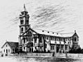
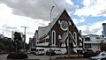
1893 sketch from Peel Street of the first St Mary's Church (left, now demolished) and the proposed second St Mary's Church (never fully completed)
-
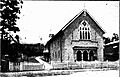
South Brisbane Congregational Church in Vulture Street, 1893
-
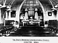
Interior of the 1893 South Brisbane Congregational Church
-
St George's Greek Orthodox Church, 2020
-
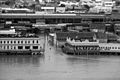
1974 flood in South Brisbane
-
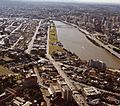
South Brisbane, 1983


,_Brisbane_River,_Brisbane_CBD_(right),_1983.jpg)
