
South Bristol, Maine facts for kids
Quick facts for kids
South Bristol, Maine
|
|
|---|---|

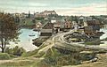
Christmas Cove c. 1906
|
|

Location in Lincoln County and the state of Maine
|
|
| Country | United States |
| State | Maine |
| County | Lincoln |
| Incorporated | 1915 |
| Area | |
| • Total | 29.68 sq mi (76.87 km2) |
| • Land | 13.10 sq mi (33.93 km2) |
| • Water | 16.58 sq mi (42.94 km2) |
| Elevation | 43 ft (13 m) |
| Population
(2020)
|
|
| • Total | 1,127 |
| • Density | 86/sq mi (33.2/km2) |
| Time zone | UTC-5 (Eastern (EST)) |
| • Summer (DST) | UTC-4 (EDT) |
| ZIP code |
04568
|
| Area code(s) | 207 |
| FIPS code | 23-70240 |
| GNIS feature ID | 0582733 |
South Bristol is a town in Lincoln County, Maine, United States. The population was 1,127 at the 2020 census. A fishing and resort area, South Bristol includes the villages of Walpole and Christmas Cove, the latter on Rutherford Island. The town has three nature preserves.
History
This was once territory of the Wawenock (or more precisely Walinakiak, meaning "People of the Bays") Abenaki Indians, who traveled in canoes to hunt for fish, shellfish, seals and seafowl. In 1614, Captain John Smith explored the coast, and is said to have named Christmas Cove when he visited it on Christmas Day. The land was subsequently part of the Pemaquid Patent, granted by the Plymouth Council for New England in 1631 to Robert Aldsworth and Gyles Elbridge, merchants from Bristol, England, from which the town derives its name.
A palisade fort and settlement were built on the adjacent Pemaquid Peninsula. Between 1630 and 1650, the area was the center for fur trading in Maine. It was attacked and rebuilt repeatedly during the French and Indian Wars, with the final two attacks occurring in 1747 at Fort Frederick. In 1765, Bristol was incorporated as a town, with South Bristol its western portion. On March 26, 1915, South Bristol was set off and incorporated as a separate town.
In the 1800s, the village of Walpole was noted for brickmaking and ice harvesting. Brickyards along the Damariscotta River supplied many of the bricks used to build Boston's Back Bay neighborhood. The ice business faded with the advent of refrigeration, but the Thompson Ice House, established in 1826, is now preserved as the Thompson Ice Harvesting Museum. Bristol Yacht Building Company, later known as H.F. Gamage Shipbuilding, built minesweepers for the United States Navy during World War II. Shipbuilding has remained important, with schooners, fishing trawlers, lobster boats and yachts constructed at the town. The Hudson River Sloop Clearwater was built here in 1968. Other industries in South Bristol are fishing, lobstering, clamming, aquaculture and tourism.
The peninsula and Rutherford Island are connected by a swing bridge, one of only three in Maine, which spans "The Gut." For well over a century, Rutherford Island in particular has been a vacation destination for families from Massachusetts, Connecticut, New York and New Jersey. Many homes on the island are owned by these families.
-
View of South Bristol in 1908
-
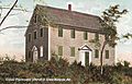
Walpole Meeting House c. 1908
-
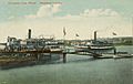
Steamboat landing in 1910


Geography
According to the United States Census Bureau, the town has a total area of 29.68 square miles (76.87 km2), of which, 13.10 square miles (33.93 km2) of it is land and 16.58 square miles (42.94 km2) is water. Half of South Bristol is located on a peninsula, the other half on Rutherford Island. The Island was named after the Reverend Robert Rutherford who came with David Dunbar's group to the area from North Ireland, in 1729.
The town is crossed by Maine State Route 129. It is bordered on the west by the Damariscotta River, on the north by Bristol, on the east by John's Bay, and on the south by the Gulf of Maine and Atlantic Ocean.
Demographics
| Historical population | |||
|---|---|---|---|
| Census | Pop. | %± | |
| 1920 | 581 | — | |
| 1930 | 563 | −3.1% | |
| 1940 | 582 | 3.4% | |
| 1950 | 631 | 8.4% | |
| 1960 | 610 | −3.3% | |
| 1970 | 664 | 8.9% | |
| 1980 | 800 | 20.5% | |
| 1990 | 825 | 3.1% | |
| 2000 | 897 | 8.7% | |
| 2010 | 892 | −0.6% | |
| 2020 | 1,127 | 26.3% | |
| U.S. Decennial Census | |||

2010 census
As of the census of 2010, there were 892 people, 418 households, and 275 families residing in the town. The population density was 68.1 inhabitants per square mile (26.3/km2). There were 1,076 housing units at an average density of 82.1 per square mile (31.7/km2). The racial makeup of the town was 98.5% White, 0.6% African American, 0.1% Native American, 0.2% Asian, and 0.6% from two or more races. Hispanic or Latino of any race were 0.6% of the population.
There were 418 households, of which 19.6% had children under the age of 18 living with them, 55.7% were married couples living together, 8.1% had a female householder with no husband present, 1.9% had a male householder with no wife present, and 34.2% were non-families. 29.4% of all households were made up of individuals, and 16% had someone living alone who was 65 years of age or older. The average household size was 2.13 and the average family size was 2.57.
The median age in the town was 54.1 years. 15.8% of residents were under the age of 18; 3.8% were between the ages of 18 and 24; 17.2% were from 25 to 44; 32.9% were from 45 to 64; and 30.2% were 65 years of age or older. The gender makeup of the town was 48.4% male and 51.6% female.
Sites of interest
See also
 In Spanish: South Bristol (Maine) para niños
