South Brunswick, New Jersey facts for kids
Quick facts for kids
South Brunswick, New Jersey
|
|
|---|---|
|
Township
|
|
| Township of South Brunswick | |
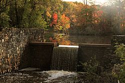
Davidson's Mill Pond on the Lawrence Brook, site of the former grist mill
|
|
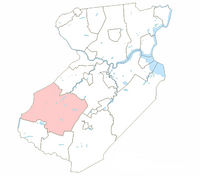
Location of South Brunswick within Middlesex County.
|
|
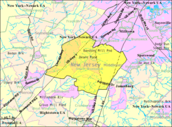
Census Bureau map of South Brunswick, New Jersey.
|
|
| Country | |
| State | |
| County | Middlesex |
| Earliest mention | February 28, 1778 |
| Incorporated | February 21, 1798 |
| Government | |
| • Type | Faulkner Act (council–manager) |
| • Body | Township Council |
| Area | |
| • Total | 41.02 sq mi (106.23 km2) |
| • Land | 40.61 sq mi (105.19 km2) |
| • Water | 0.40 sq mi (1.04 km2) 0.98% |
| Area rank | 51st of 565 in state 2nd of 25 in county |
| Elevation | 82 ft (25 m) |
| Population | |
| • Total | 47,043 |
| • Rank | 43rd of 566 in state 8th of 25 in county |
| • Density | 1,146.83/sq mi (442.841/km2) |
| • Density rank | 373rd of 566 in state 23rd of 25 in county |
| Time zone | UTC−05:00 (Eastern (EST)) |
| • Summer (DST) | UTC−04:00 (Eastern (EDT)) |
| ZIP Codes | |
| Area code(s) | 609 and 732 |
| FIPS code | 3402368790 |
| GNIS feature ID | 0882162 |
South Brunswick is a township in Middlesex County, New Jersey, United States. The township is centrally located within the Raritan Valley region and an outer-ring suburb of New York City in the New York metropolitan area. As of the 2020 United States Census, the township's population was 47,043, reflecting an increase of 3,626 (+8.4%) from the 43,417 counted in the 2010 Census.
South Brunswick was first mentioned in Freeholder minutes on February 28, 1778, as being formed from New Brunswick Township. It was formally incorporated as one of New Jersey's initial group of 104 townships on February 21, 1798. Portions of the township have been taken to form Cranbury (as of March 7, 1872) and Plainsboro (on April 1, 1919).
Niche.com placed Monmouth Junction in the top 10 of its “2021 Best Places to Live in New Jersey”. In 2021, SafeWise placed South Brunswick in the “100 Safest Cities in America”.
Contents
History
South Brunswick Township was incorporated by an act of the New Jersey Legislature on February 21, 1798. In the 18th and 19th centuries, the community was primarily agricultural. The Straight Turnpike, now U.S. Route 1, was constructed in 1804. The township got its named from New Brunswick, which in turn was named after the city of Braunschweig (called Brunswick in the Low German language), in state of Lower Saxony, in Germany. Braunschweig was an influential and powerful city in the Hanseatic League, later in the Holy Roman Empire, and was an administrative seat for the Duchy (and later Principality) of Hanover. Shortly after the first settlement of New Brunswick in colonial New Jersey, George, Duke of Brunswick-Lüneburg, and Elector of Hanover, of the House of Hanover (also known as the House of Brunswick), became King George I of Great Britain (1660–1727). Alternatively, the city derived its name from King George II of Great Britain, the Duke of Brunswick-Lüneburg.
In 1872, the Legislature first reduced the size of South Brunswick with the creation of the separate Cranbury Township from the southern portion of South Brunswick. In 1885, it redefined and enlarged the boundaries of Cranbury, and Plainsboro Township was formed in 1919. The present boundaries of South Brunswick date back to this last change.
During the 20th century, South Brunswick saw extensive transformation with the impact of changes in transportation technology. The New Brunswick and Trenton Fast Line began operation in 1900, a trolley line running parallel to the Old Straight Turnpike of 1804 (Route 1), intersecting George's Road just north of the Five Corners intersection in Dayton. This trolley provided daily passenger and freight service, stopping at a local crossroads. The New Jersey Turnpike opened in 1951, again roughly parallel to Route 1, on the eastern edge of the Township. One effect of the Turnpike opening up Interchange 8A (just outside the township) was the transformation of the agricultural area on the southeast corner of South Brunswick to that of a burgeoning industrial development. Significant portions of land between Route 130 and the turnpike consist largely of warehouses.
In 1980, the township's population approached 18,000. In 1990, this figure reached 25,792 and by 2010, South Brunswick had over 43,000 residents. Much of the township's 42 square miles (110 km2) remain undeveloped and there are still significant amounts of wetlands, woodlands and open space within the community.
Geography
According to the United States Census Bureau, the township had a total area of 41.039 square miles (106.290 km2), including 40.648 square miles (105.278 km2) of land and 0.391 square miles (1.012 km2) of water (0.95%).
Dayton (2010 Census population of 7,063), Heathcote (5,821), Kendall Park (9,339), Kingston (1,222 of a total CDP population of 1,493, with the balance in Franklin Township) and Monmouth Junction (2,887) are unincorporated communities and census-designated places (CDPs) located within South Brunswick Township.
Other unincorporated communities, localities and place names located partially or completely within the township include: Cottageville, and Ten Mile Run.
Because the township is served by several different zip codes, Dayton, Monmouth Junction, Kendall Park, Kingston, Jamesburg, Cranbury, Princeton and even North Brunswick are often used in place of the township's name, even when referring to areas located beyond their defined boundaries.
Dayton was first known simply as The Cross Roads, where James Whitlock built a tavern on Georges Road around 1750. Early enterprises included a brick manufacturer and large nursery. In 1866, the name was changed from Cross Roads to Dayton, in honor of William L. Dayton, an attorney for the Freehold and Jamesburg Agricultural Railroad. Dayton had helped settle disputes arising from the location of a railroad right-of-way. He was later a United States Senator, was the first Republican nominee for Vice President (in 1856), and Minister to France.
Deans originated from its location on both Crosswicknung Trail (Georges Road) and Lawrence Brook. Dams were built on the brook, creating Deans Pond.
With increased mobility and a growing population, the suburban style residential development was born after the World War II and Kendall Park was begun in the 1950s. Kendall Park is located off Route 27, the old Indian trail and major thoroughfare of earlier centuries.
Kingston's location on the Lenape Assunpink Trail where it crossed the Millstone River was the prime factor in its early prominence. Kingston was by far the most active and important community, being situated on both the heavily traveled King's Road and Millstone River, combining commercial activities of both mills and taverns. The Kingston Village Advisory Committee, jointly appointed by the South Brunswick and Franklin Township Councils, reports to the Township Council on matters of concern to residents of Kingston. Kingston has been designated as a Village Center by the New Jersey State Planning Commission and is overseen by an advisory commission that consists of seven members from Franklin Township and South Brunswick.
Monmouth Junction was created as the junction of three rail branches, the New York division of the Pennsylvania Railroad, the Rocky Hill and the Jamesburg and Freehold.
The Lawrence Brook, a tributary of the Raritan River, flows through the township.
Pigeon Swamp State Park is a New Jersey state park located on Deans Rhode Hall Road (Middlesex CR-610). The park has 1,078 acres (4.36 km2) of undeveloped land.
The township borders Cranbury Township, East Brunswick Township, Monroe Township, North Brunswick Township and Plainsboro Township in Middlesex County; Princeton in Mercer County; and Franklin Township in Somerset County.
Climate
South Brunswick is in the humid continental climate zone. Average Winter-time high temperatures range from 38 to 43 °F (3 to 6 °C), and the lows range from 19 to 24 °F (−7 to −4 °C) degrees with the record low being −16 °F (−27 °C). Average summer-time high temperatures range from 84 to 87 °F (29 to 31 °C), though temperatures exceed 90 °F (32 °C) often with the record high being 105 °F (41 °C). The summertime lows range from 63 to 67 °F (17 to 19 °C) degrees. South Brunswick can receive much snow during the winter months, sometimes up to 3 feet (0.91 m). About 4 to 5 inches (10 to 13 cm) of rain falls every month, and is evenly spread throughout the year, though the area can go through long periods of drought or long-lasting periods with little to no rain. During winter and early spring, South Brunswick can in some years experience "nor'easters", which are capable of causing blizzards or flooding throughout the northeastern United States. Hurricanes and tropical storms (such as Hurricane Irene in 2011), tornadoes and earthquakes are rare.
| Climate data for South Brunswick Township (Dayton), New Jersey | |||||||||||||
|---|---|---|---|---|---|---|---|---|---|---|---|---|---|
| Month | Jan | Feb | Mar | Apr | May | Jun | Jul | Aug | Sep | Oct | Nov | Dec | Year |
| Average high °F (°C) | 39 (4) |
43 (6) |
51 (11) |
62 (17) |
72 (22) |
81 (27) |
86 (30) |
84 (29) |
77 (25) |
66 (19) |
55 (13) |
44 (7) |
63 (18) |
| Average low °F (°C) | 22 (−6) |
24 (−4) |
31 (−1) |
40 (4) |
49 (9) |
59 (15) |
64 (18) |
62 (17) |
54 (12) |
43 (6) |
35 (2) |
27 (−3) |
43 (6) |
| Average precipitation inches (mm) | 4.10 (104) |
2.98 (76) |
4.11 (104) |
4.08 (104) |
4.57 (116) |
3.86 (98) |
4.97 (126) |
4.46 (113) |
4.38 (111) |
3.39 (86) |
3.95 (100) |
3.93 (100) |
48.78 (1,239) |
Demographics
| Historical population | |||
|---|---|---|---|
| Census | Pop. | %± | |
| 1790 | 1,817 | — | |
| 1810 | 2,332 | — | |
| 1820 | 2,489 | 6.7% | |
| 1830 | 2,557 | 2.7% | |
| 1840 | 2,797 | 9.4% | |
| 1850 | 3,368 | 20.4% | |
| 1860 | 3,816 | 13.3% | |
| 1870 | 3,779 | −1.0% | |
| 1880 | 2,803 | −25.8% | |
| 1890 | 2,403 | −14.3% | |
| 1900 | 2,337 | −2.7% | |
| 1910 | 2,443 | 4.5% | |
| 1920 | 2,206 | −9.7% | |
| 1930 | 2,758 | 25.0% | |
| 1940 | 3,129 | 13.5% | |
| 1950 | 4,001 | 27.9% | |
| 1960 | 10,278 | 156.9% | |
| 1970 | 14,058 | 36.8% | |
| 1980 | 17,127 | 21.8% | |
| 1990 | 25,792 | 50.6% | |
| 2000 | 37,734 | 46.3% | |
| 2010 | 43,417 | 15.1% | |
| 2020 | 47,043 | 8.4% | |
| Population sources: 1790–1920 1840 1850–1870 1850 1870 1880–1890 1890–1910 1910–1930 1930–1990 2000 2010 * = Lost territory in previous decade. 2020 |
|||
Census 2020
The 2020 United States census counted 47,043 people in the township, which was a gain of 8.4% from the 2010 census. The racial makeup was 48.1% Asian, 35.5% white, 7.6% Black, 7.5%, and 5.5% reported two or more races. 7.5% of respondents reported Latino ethnicity. There were 16,647 households in the township.
Census 2010
As of the census of 2010, there were 43,417 people, 15,069 households, and 11,694 families residing in the township. The population density was 1,068.1 per square mile (412.4/km2). There were 15,708 housing units at an average density of 386.4 per square mile (149.2/km2)*. The racial makeup of the township was 52.08% (22,611) White, 7.71% (3,348) Black or African American, 0.17% (72) Native American, 35.91% (15,592) Asian, 0.02% (8) Pacific Islander, 1.52% (658) from other races, and 2.60% (1,128) from two or more races. [[Hispanic (U.S. Census)|Hispanic or Latino of any race were 6.04% (2,624) of the population.
There were 15,069 households out of which 44.3% had children under the age of 18 living with them, 66.1% were married couples living together, 8.8% had a female householder with no husband present, and 22.4% were non-families. 18.8% of all households were made up of individuals, and 6.0% had someone living alone who was 65 years of age or older. The average household size was 2.88 and the average family size was 3.33.
In the township, the population was spread out with 27.7% under the age of 18, 6.4% from 18 to 24, 27.7% from 25 to 44, 28.8% from 45 to 64, and 9.4% who were 65 years of age or older. The median age was 38.6 years. For every 100 females there were 93.9 males. For every 100 females ages 18 and old there were 90.4 males.
The Census Bureau's 2006–2010 American Community Survey showed that (in 2010 inflation-adjusted dollars) median household income was $100,950 (with a margin of error of +/- $2,777) and the median family income was $116,127 (+/- $5,529). Males had a median income of $81,297 (+/- $2,632) versus $55,477 (+/- $3,835) for females. The per capita income for the borough was $40,468 (+/- $1,430). About 2.1% of families and 3.1% of the population were below the poverty line, including 3.4% of those under age 18 and 5.6% of those age 65 or over.
Transportation
Roads and highways
As of May 2010[update], the township had a total of 192.83 miles (310.33 km) of roadways, of which 151.43 miles (243.70 km) were maintained by the municipality, 21.09 miles (33.94 km) by Middlesex County and 16.75 miles (26.96 km) by the New Jersey Department of Transportation and 3.56 miles (5.73 km) by the New Jersey Turnpike Authority.
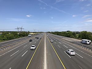
The most prominent highway passing through South Brunswick is a 3+1⁄2-mile (5.6 km) section of the New Jersey Turnpike (Interstate 95). This highway crosses the eastern part of the township, and a few ramps that lead to the toll gate for Interchange 8A pass through the township, with the majority of the interchange just outside the municipality's border in Monroe Township. Other major highways that the township also hosts include U.S. Route 1, U.S. Route 130, Route 27 and Route 32. A few county routes, such as 535 and 522, pass through the township.
A number of proposed Turnpike Authority maintained roads were to traverse South Brunswick. The first was the Driscoll Expressway which was to start from the Garden State Parkway at exit 80 in Toms River and end 3 miles (4.8 km) north of exit 8A along the turnpike in South Brunswick. This was cancelled in the 1980s. The other proposed road was a west-east spur, Route 92. While the majority of the spur was to be in South Brunswick, it was to begin at US 1, just north of the intersection with Ridge Road in South Brunswick, and terminate at the tollgate for Exit 8A. However this was cancelled on December 1, 2006.
Public transportation
Near the intersection of Route 32 and 130, there is a park and ride, where commuters can take buses to New York City. Suburban Transit offers service on Line 300 to the Port Authority Bus Terminal, Grand Central Terminal and Manhattan's East Side, while Line 600 serves Downtown Manhattan / Wall Street.
Commuter bus service to Midtown Manhattan is also offered by discount commuter transportation company OurBus, during peak hours.
The Middlesex County Area Transit (MCAT) Shuttle offers scheduled service across the county, with connections to NJ Transit buses and train service.
The Monmouth Ocean Middlesex Line is a proposal by New Jersey Transit to restore passenger railway service to the region. Herrod Blvd and Monmouth Junction (where the line would conjoin with the Northeast Corridor) would be potential stops on the 'MOM' Line in South Brunswick.
As of now, the nearest train stations to the township are located at Princeton Junction and New Brunswick along the Northeast Corridor Line.
Economy
Top employers
Major employers in the township include:
| Employer | Community |
|---|---|
| Dow Jones & Company | Monmouth Junction |
| Maserbuild Industries LLC | Dayton |
| South Brunswick Public Schools | Monmouth Junction |
| International Flavors & Fragrances | Dayton |
| High Grade Beverage | Deans |
| Freeze Division-Central Mills | Monmouth Junction |
| Tris Pharma Inc. | Monmouth Junction |
| Guardian Drug Co | Dayton |
Education
The South Brunswick Public Schools serves students in pre-kindergarten through twelfth grade. The district has grown substantially in recent decades, with district enrollment more than doubling in the two decades from 1991 and high school enrollment doubling to nearly 2,000 in the decade prior to 2001, and increasing by another 1,000 in the subsequent decade.
As of the 2018–19 school year, the district, comprised of 10 schools, had an enrollment of 8,623 students and 634.5 classroom teachers (on an FTE basis), for a student–teacher ratio of 13.6:1. Schools in the district (with 2018–19 enrollment data from the National Center for Education Statistics) are Brooks Crossing and Deans Elementary School (589 students; in grades K-5), Brunswick Acres Elementary School (534; K-5), Cambridge Elementary School (512; PreK-5), Constable Elementary School (464; K-5), Greenbrook Elementary School (391; K-5), Indian Fields and Dayton Elementary School (668; K-5), Monmouth Junction Elementary School (347; PreK-5), Crossroads Middle School North (990; 6-8), Crossroads Middle School South (1,107; 6-8) and South Brunswick High School (2,939; 9-12).
St. Augustine of Canterbury School is PreK-8 elementary school in Kendall Park operating under the auspices of the Roman Catholic Diocese of Metuchen. In 2016, the school was one of ten schools in New Jersey, and one of the private schools, recognized as a National Blue Ribbon School by the United States Department of Education, a recognition celebrating excellence in academics.
Notable people
People who were born in, residents of, or otherwise closely associated with South Brunswick include:
- Leon Bibel (1913–1995), Polish-born American painter and printmaker during the Great Depression.
- Mya Breitbart (born 1978), Professor of Biological Oceanography at the University of South Florida's College of Marine Science who was awarded Popular Science magazine's 'Brilliant 10' for 2013.
- Mike Elko (born 1977), head coach for the Duke Blue Devils football team.
- Donald Fagen (born 1948), musician and songwriter, best known as the co-founder of the rock band Steely Dan.
- Edith King (1896–1973), stage and film actress.
- Ed Moran (born 1981), retired track and road runner who specialized in various long-distance disciplines who was a gold medalist in the 5000-meter race at the 2007 Pan American Games.
- David Neumann (born 1965), Dancer, Actor, and Tony nominated Choreographer.
- Walter Perez, weekend morning co-anchor, journalist and weekday reporter for WPVI-TV, the ABC network affiliate in Philadelphia.
- Steven Portnoy (born 1981), CBS News Radio White House correspondent.
- Anna Quindlen (born 1952), best-selling author, journalist, and Pulitzer Prize-winning opinion columnist.
- Ricardo Romero (born 1978), MMA fighter.
- Mohamed Sanu (born 1989), wide receiver for the San Francisco 49ers.
- Sydney Schneider (born 1999), goalkeeper for the UNC Wilmington Seahawks and the Jamaica women's national football team.
- George Segal (1924–2000), painter and sculptor associated with the Pop Art movement, who was presented with a National Medal of Arts in 1999.
- DeForest Soaries (born 1951), pastor and former chairman of the Election Assistance Commission.
- Katherine S. Squibb (1949–2018), toxicologist who specialized in metal toxicity.
- C. Vivian Stringer (born 1948), head coach for the Rutgers Scarlet Knights women's basketball team and one of the winningest coaches in women's college basketball history.
- Tammy Tibbetts (born c. 1985), co-founder and CEO of the non-profit organization She's the First.
- Andrew Zwicker (born 1964), a physicist at the Princeton Plasma Physics Laboratory and a member of the New Jersey General Assembly representing the 16th Legislative District since January 2016.
Images for kids
See also
 In Spanish: Municipio de South Brunswick para niños


