
South Gate, California facts for kids
Quick facts for kids
South Gate, California
|
||
|---|---|---|
| City of South Gate | ||

Hoot Owl Cafe in 1977, before it was demolished
|
||
|
||
| Nickname(s):
"Azalea City"
|
||

Location of South Gate in Los Angeles County, California
|
||

South Gate, California
Location in the Los Angeles metropolitan area

South Gate, California
Location in southern California

South Gate, California
Location in California

South Gate, California
Location in the United States
|
||
| Country | ||
| State | ||
| County | ||
| Incorporated | January 20, 1923 | |
| Area | ||
| • Total | 7.35 sq mi (19.04 km2) | |
| • Land | 7.24 sq mi (18.74 km2) | |
| • Water | 0.12 sq mi (0.30 km2) 1.59% | |
| Elevation | 115 ft (35 m) | |
| Population
(2010)
|
||
| • Total | 94,396 | |
| • Estimate
(2019)
|
93,444 | |
| • Rank | 83rd in California | |
| • Density | 12,913.76/sq mi (4,986.06/km2) | |
| Time zone | UTC-8 (PST) | |
| • Summer (DST) | UTC-7 (PDT) | |
| ZIP Code |
90280
|
|
| Area code(s) | 323/ 562 | |
| FIPS code | 06-73080 | |
| GNIS feature ID | 1652795 | |

South Gate is the 17th largest city in Los Angeles County, California, United States, with 7.4 square miles (19 km2). South Gate is located 7 miles (11 km) southeast of Downtown Los Angeles. It is part of the Gateway Cities region of southeastern Los Angeles County.
The city was incorporated on January 20, 1923, and it became known as the "Azalea City" when it adopted the flower as its symbol in 1965. As of the 2010 census, the city had a population of 94,396.
In 1990, South Gate was one of ten U.S. communities to receive the All-America City Award from the National Civic League.
Contents
Native Americans
The South Gate area was inhabited by the Gabrielino/Tongva Indians before development by Spanish ranchers.
Exploration
In the summer of 1769, a group of Spanish explorers set out from the coast of San Diego to explore the uncharted territory between San Diego and the Bay of Monterey. With them was Father Juan Crespi, considered by historians to be one of the great diarists of the New World explorations. His daily entries were remarkably revealing of the country through which the caravan passed. The explorers proceeded in the general direction of the San Gabriel Valley, across the Los Angeles River, which Crespi named "Porciuncula" on August 2, 1769.
Land grants
Among the early Spanish settlers was one of California’s first families, the Lugos. The Lugo land grant encompassed a great part of what is now the City of South Gate.
While Francisco Lugo was stationed at Mission San Antonio de Padua near Salinas, California, his first California son, Antonio Maria Lugo was born in 1775. That son became Don Antonio Maria Lugo, Spanish aristocrat and soldier, who settled on 30,000 acres (120 km2) of land that encompasses what is now the City of South Gate. In 1810, the King of Spain formally granted the land to Lugo as a reward for his and his father's military service. Rancho San Antonio extended from the low range of hills which separated it from the San Gabriel Valley to the old Dominguez Ranch at its south, and from the eastern boundary of the pueblo of Los Angeles to the San Gabriel River. Lugo also became the mayor of Los Angeles, from 1816 to 1819,
A little more than 100 years after the establishment of the Lugo Land Grant, the area at the south gate of the ranch became the City of South Gate. As Don Lugo's family grew, he obtained San Bernardino Rancho and other grants in his children's names.
The future South Gate site and adjacent mesas presented a colorful spectacle when countless heads of cattle and horses were herded from all directions to a common point for the annual great spring rodeo. Lugo would direct the proceedings and settle disputes regarding ownership of contested animals as well as adjudicate agricultural disputes. In his saddle, he was the court and the plains his courtroom.
Don Antonio's son Vincente (1820–1889) built his adobe dwelling in the 1850s on 5.5 acres (22,000 m2). It is known as Lugo Ranch, and is situated on modern day Gage Avenue in the City of Bell Gardens.
Tracts
Before the end of the 1870s, much of the original land grant had been replaced by tracts of 40-acre (160,000 m2). By 1880, cattle raising had been replaced by agriculture as the most important local industry. During the years between 1910 and 1940, most of the agricultural land was replaced by homes and factories.
Tweedy family
The R.D. Tweedy family played an important part in South Gate's history. Tweedy was born in 1812 in Illinois and came to California by ox-drawn cart in 1852. Mrs. Tweedy rode across the prairies perched on her rocking chair in the cart. The family was large, and several generations have lived in this city. The family members bought some 2,000 acres (8.1 km2) of the land on which much of South Gate was built. The "downtown business district" in South Gate was named after the family and is known as the Tweedy Mile.
Naming
The city was named in 1918 after the South Gate Gardens on the Cudahy Ranch. The city was incorporated five years later, in 1923, using the shortened form of the name. The name refers to the city's being south of Los Angeles.
Geography
According to the United States Census Bureau, the city has a total area of 7.4 square miles (19 km2). 7.2 square miles (19 km2) of it is land and 0.1 square miles (0.26 km2) of it is water. The total area is 1.59% water.
The Los Angeles River runs through the eastern part of South Gate.
Climate
South Gate has a semi-arid Mediterranean climate with mild winters and hot, dry summers. The average annual precipitation is 14.8 inches (380 mm) per year with most occurring between November and April. Temperatures range from a low of 40 °F (4 °C) to a high of 110 °F (43 °C). The average daily temperatures range from 54 °F (12 °C) to 73 °F (23 °C).
Demographics
| Historical population | |||
|---|---|---|---|
| Census | Pop. | %± | |
| 1930 | 19,632 | — | |
| 1940 | 26,945 | 37.3% | |
| 1950 | 51,116 | 89.7% | |
| 1960 | 53,831 | 5.3% | |
| 1970 | 56,909 | 5.7% | |
| 1980 | 66,784 | 17.4% | |
| 1990 | 86,284 | 29.2% | |
| 2000 | 96,375 | 11.7% | |
| 2010 | 94,396 | −2.1% | |
| 2019 (est.) | 93,444 | −1.0% | |
| U.S. Decennial Census | |||
2010
The 2010 United States Census reported that South Gate had a population of 94,396. The population density was 12,837.6 people per square mile (4,956.6/km2). The racial makeup of South Gate was 47,645 (50.5%) White, 3,209 (3.4%) Non-Hispanic White, 890 (0.9%) African American, 878 (0.9%) Native American, 732 (0.8%) Asian, 99 (0.1%) Pacific Islander, 40,624 (43.0%) from other races, and 3,528 (3.7%) from two or more races. Hispanic or Latino of any race were 89,442 persons (94.8%).
The Census reported that 94,308 people (99.9% of the population) lived in households, 16 (0%) lived in non-institutionalized group quarters, and 72 (0.1%) were institutionalized.
There were 23,278 households, out of which 13,805 (59.3%) had children under the age of 18 living in them, 13,183 (56.6%) were opposite-sex married couples living together, 4,706 (20.2%) had a female householder with no husband present, 2,261 (9.7%) had a male householder with no wife present. There were 1,879 (8.1%) unmarried opposite-sex partnerships, and 134 (0.6%) same-sex married couples or partnerships. 2,292 households (9.8%) were made up of individuals, and 996 (4.3%) had someone living alone who was 65 years of age or older. The average household size was 4.05. There were 20,150 families (86.6% of all households); the average family size was 4.24.
The population was spread out, with 29,374 people (31.1%) under the age of 18, 11,298 people (12.0%) aged 18 to 24, 28,039 people (29.7%) aged 25 to 44, 19,062 people (20.2%) aged 45 to 64, and 6,623 people (7.0%) who were 65 years of age or older. The median age was 29.4 years. For every 100 females, there were 96.4 males. For every 100 females age 18 and over, there were 93.9 males.
There were 24,160 housing units at an average density of 3,285.7 per square mile (1,268.6/km2), of which 10,658 (45.8%) were owner-occupied, and 12,620 (54.2%) were occupied by renters. The homeowner vacancy rate was 1.5%; the rental vacancy rate was 3.6%. 46,665 people (49.4% of the population) lived in owner-occupied housing units and 47,643 people (50.5%) lived in rental housing units.
During 2015–2019, South Gate had a median household income of $52,321, with 17.2% of the population living below the federal poverty line. For people ages 25 and over, 56.7% had a high school degree or higher while 9.4% had a bachelor's degree or higher.
2000
As of the 2000 census, there were 96,375 people, 23,213 households, and 20,063 families residing in the city. The population density was 13,084.6 per square mile (5,052.0/km2). There were 24,269 housing units at an average density of 3,294.9 per square mile (1,271.4/km2).
The racial makeup of the city was 41.6% White (0.78% White Non-Hispanic), 1.2% Black or African-American, 0.9% American Indian and Alaska Native, 0.8% Asian and 51% some other race (mostly Mestizo). 92% of the population were Hispanic or Latino of any race.
There were 23,213 households, out of which 58.2% had children under the age of 18 living with them, 59.6% were married couples living together, 18.4% had a female householder with no husband present, and 13.6% were non-families. 10.4% of all households were made up of individuals, and 4.8% had someone living alone who was 65 years of age or older. The average household size was 4.15 and the average family size was 4.37. In the city, the population was spread out, with 35.6% under the age of 18, 12.5% from 18 to 24, 31.6% from 25 to 44, 14.9% from 45 to 64, and 5.4% who were 65 years of age or older. The median age was 26 years. For every 100 females, there were 98.3 males. For every 100 females age 18 and over, there were 95.5 males.
The median income for a household in the city was $35,695, and the median income for a family was $35,789. Males had a median income of $25,350 versus $19,978 for females. The per capita income for the city was $10,602. 19.2% of the population and 17.4% of families were below the poverty line. Out of the total population, 24.2% of those under the age of 18 and 12.0% of those 65 and older were living below the poverty line.
Religion
There are approximately 40 churches located in the City representing a variety of religious denominations. 53.4% of the people in South Gate, CA are religious. 37.0% are Catholic; 6.7% are Protestant; 1.6% are members of The Church of Jesus Christ of Latter-day Saints; 5.2% are another Christian faith; 1.1% are Jewish; 1.1% are "an eastern faith"; 0.7% are Muslim.
Demographics history
South Gate developed during the 1920s and 1930s as an industrial city (primarily in "metal-bashing" industries) and its blue-collar community was predominantly non-Hispanic white.
During the 1940s and 1950s, South Gate was one of the most fiercely segregationist cities in Southern California. Gangs of white youths were known to prowl the streets looking for blacks who dared to cross over from neighboring Watts. One of the most infamous clubs of the area at that time was the "Spook Hunters".
Since the 1970s, South Gate has had a large Hispanic community, which became dominant in the 1990s as working-class Hispanics and immigrant Latin American families filled the vacuum left by non-Hispanic whites leaving for more space in the outer suburbs.
Economy
South Gate was the location of a General Motors automobile manufacturing facility called South Gate Assembly which was built in 1936. Originally built to manufacture Buick, Oldsmobile, and Pontiac vehicles, it was converted to war production after 1940, and was the primary supplier of aircraft engines for the B-24 Liberator, Douglas C-47 Skytrain, and the Douglas C-54 Skymaster, as the Douglas and Consolidated companies has aircraft manufacturing facilities in Long Beach and San Diego. During the 1950s, it was GM's highest producing facility. The plant was closed in 1982 and is now the location of South East High School as of 2005.
As of June 2009, California's EDD lists the unemployment rate in South Gate as 14.4%, with negative job growth. The California State Board of Equalization lists South Gate's sale tax rate as 10.75%. The income per capita is $11,566, which includes all adults and children. The median household income is $41,064.
South Gate's commercial activity is concentrated in the following zones:
- Tweedy Mile (on Tweedy Boulevard from Alameda Street to Atlantic Avenue)
- Firestone Boulevard (from Alameda Street to Garfield Avenue)
- El Paseo (Corner of Firestone Boulevard and Garfield Avenue)
- Hollydale (on Garfield Avenue from I-105 to Imperial Highway)
As of April 1, 2009, the City of South Gate imposed a 10.25-percent sales tax (statewide plus local supplementary, which is now 9.75% with the expiration of the temporary tax increase under Proposition 1A), which matches Pico Rivera's sales tax rate as the highest in the State of California.
On July 9, 2009, the South Gate City Council held a special meeting where a resolution was adopted declaring a fiscal emergency for the City of South Gate.
Education
Schools located in South Gate include: 21 public (13 elementary, 3 high school, 3 charter schools and 2 middle school and 1 span school and 1 continuation high school) and two parochial schools. Adult Education classes are conducted at both the junior and senior high schools. The city is also served by 3 community colleges (Compton, Cerritos and East Los Angeles—main campus and South Gate satellite) and 3 California State Universities (Dominguez Hills, Long Beach and Los Angeles.)
Public schools
Most of South Gate is served by the Los Angeles Unified School District public school system. A small section of South Gate is served by the Paramount Unified School District and Downey Unified School District.
Los Angeles Unified School District
LAUSD primary schools
- Bryson Avenue Elementary School (opened 1931, partially a Math, Science, Technology magnet school)
- Independence Elementary School (opened 1997)
- Liberty Boulevard Elementary School (opened 1932)
- Madison Elementary School (opened 2005)
- Montara Avenue Elementary School (opened 1988)
- San Gabriel Avenue Elementary School (opened 1920)
- San Miguel Avenue Elementary School (opened 1989, partially a math and science magnet school)
- Stanford Avenue Elementary School (1-5, opened 1924)
- Stanford New Primary Center (K, opened 2004)
- State Street Elementary School (opened 1932)
- Tweedy Elementary School (Originally Opened 1931) (opened 1950)
- Victoria Avenue Elementary School (opened 1925)
- Willow Avenue Elementary School (opened 2012)
LAUSD charter schools
- Firestone (opened 2010)
- Aspire Gateway (opened 2010)
- Valiente College Preparatory Charter School ( 2015)
- KIPP Corazon (2017)
LAUSD middle schools
- International Studies Learning Center
- South Gate Middle School (opened 1941)
- South East Middle School (opened 2004)
LAUSD high schools
- South Gate High School (opened 1932)
- South East High School (opened 2005)
- Legacy High School Complex
When South East High School opened, within the City of South Gate, the school's attendance boundary took land formerly zoned to South Gate High School, Huntington Park High School, and David Starr Jordan High School.
LAUSD span school
- International Studies Learning Center (opened in 2004)
LAUSD continuation high school
- Odyssey Continuation High School
Paramount Unified School District
- Hollydale School (K-8)
- Paramount High School
Part of South Gate is served by Downey Unified School District.
Private schools
Private primary schools
- Lollypop Lane Preschool and Kindergarten
- Redeemer Lutheran School
- Saint Helen Elementary School
Private high schools
- Academia Betel
Colleges and universities
- South Gate Satellite Campus, East Los Angeles College
Public libraries
County of Los Angeles Public Library operates:
- Leland R. Weaver Library (4035 Tweedy Boulevard )
- Hollydale Library (12000 South Garfield Avenue )
Infrastructure
Roads
- Interstate 710
- Imperial Highway
Buses
South Gate is served by Metro Local and Metro Rapid buses. The City of South Gate operates the Get Around Town Express (GATE) to provide local service.
City parks
South Gate offers nine city parks for the enjoyment of its citizens.
- South Gate Park covers a total of 96.8 acres (392,000 m2), and is the largest park within the city limits. This park is used to carry out most of the Parks and Recreation Department's community programs. There are a total of six different facilities at this park, some of which can be rented out for a variety of events. These facilities include the Municipal Auditorium, Girls Club House, 9-hole Par 3 Golf Course, Senior Recreation Center, Swim Stadium, and Sports Center. The site also features athletic fields, outdoor basketball courts, two playgrounds, tennis courts, a skate park, several shaded areas for picnics, and a Jr. Hockey Rink. The park closes at 10:00 pm.
- Hollydale Regional Park covers 56.0 acres (227,000 m2), has a playground, tennis courts, a baseball field, soccer fields, a picnic area (groups of 50+ by reservation only), and an Equestrian Center that is also available for rent. The park closes at sunset.
- Cesar Chavez Park covers 9.0 acres (36,000 m2), has two playgrounds and a pergola. No reservation is needed for picnics. The park closes at sunset.
- Circle Park covers 4.0 acres (16,000 m2), and is a neighborhood park. It has a small playground, a ball field and a grass area. The park closes at sunset.
- Hollydale Community Park covers 2.2 acres (8,900 m2), it has a playground, outdoor basketball courts, and a Community Center. The park closes at 10:00pm.
- State Street Park covers 0.8 acres (3,200 m2) and only has a grass fields. is a neighborhood park, No reservation needed for picnics. The park closes at sunset.
- Gardendale Tot Lot covers 0.45 acres (1,800 m2), and is a neighborhood park. It has a playground and a small grass area. The park closes at sunset.
- Triangle Park covers 0.3 acres (1,200 m2), has a pergola, a seating area, a bike rack, and a drinking fountain. The park closes at sunset.
- Stanford Park covers 0.19 acres (770 m2) and is a neighborhood park. It has a playground and a small grass area. The park closes at sunset.
Notable people
- Arleen Auger, opera singer; born in South Gate
- Don Bandy, pro football player
- Hal Bernson, Los Angeles City Council member, 1979–2003
- Don Buchla, inventor of Buchla music synthesizer
- Cypress Hill, Hip Hop/Rap Group
- Mark Gonzales, pro skateboarder
- Lee Greenwood, country music recording artist; born in South Gate
- Doug Griffin, Major League Baseball player
- Doug Harvey, Hall of Fame baseball umpire
- Victor Henry, UFC Fighter
- Don Horn, pro football player
- Dave Huppert, Major League Baseball player and coach
- Lou Kimzey, publisher and movie producer
- Bob Klein, tight end for NFL's Los Angeles Rams
- Mellow Man Ace, rapper
- Dick Nen, Major League Baseball player
- Walter Perez, actor
- Dick Rand, Major League Baseball player
- Lorenzo Romar - NBA player, college basketball coach
- Pete Rozelle, Commissioner of National Football League, 1960-1989
- Glenn Seaborg, Nobel Prize winner
- Niki Sullivan, an original member of Buddy Holly's Crickets.
Images for kids
-
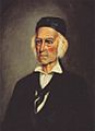
Californio land barron Antonio María Lugo was granted Rancho San Antonio in 1838, which included South Gate and the surrounding area.

See also
 In Spanish: South Gate (California) para niños
