South Riding, Virginia facts for kids
Quick facts for kids
South Riding, Virginia
|
|
|---|---|

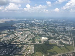
View of South Riding, with Freedom High School visible in the lower center
|
|
| Country | |
| State | |
| County | |
| Founded | January 1995 |
| Named for | South Yorkshire |
| Government | |
| • Type | Board of Directors |
| Area | |
| • Total | 6.92 sq mi (17.92 km2) |
| • Land | 6.85 sq mi (17.73 km2) |
| • Water | 0.07 sq mi (0.19 km2) |
| Elevation | 295 ft (90 m) |
| Population
(2010)
|
|
| • Total | 24,256 |
| • Estimate
(2019)
|
31,515 |
| • Density | 3,544/sq mi (1,368.3/km2) |
| Time zone | UTC−5 (Eastern (EST)) |
| • Summer (DST) | UTC−4 (EDT) |
| ZIP code |
20152 (Chantilly)
|
| Area code(s) | 703 |
| FIPS code | 51-74100 |
| GNIS feature ID | 2584921 |
South Riding is a census-designated place and planned community in Loudoun County, Virginia, United States. The South Riding homeowner association was founded in January 1995 to provide services to the community. Neighboring U.S. Route 50 and State Route 28 provide access to the Dulles/Reston/Tysons Corner technology corridor and other major employment centers in Northern Virginia and Washington, D.C.
In 2010, the population was 24,256. In 2019, the United States Census Bureau estimated it to be 31,515.
Contents
Demographics
As of 2014, South Riding has a median household income of $142,088. The average listing price for homes in South Riding is between $511,000 and $624,000. Loudoun County also ranks as the 10th most educated county in the nation.
| Historical population | |||
|---|---|---|---|
| Census | Pop. | %± | |
| 2010 | 22,982 | — | |
| 2018 (est.) | 31,071 | 35.2% | |
As of the 2010 census: White 74.1%, Black 5.08%, Asian 13.53%, Hispanic 11.18%. Between 2009 and 2014, the White population is expected to grow by 25%, the African American population by 37%, the Asian population by 90% and Hispanic population by 81%. The age breakdown of the town is 8.0% under 5 years old, 32.6% under 18 years old, and 65 years or older around 5.8%.
Education
Primary and secondary schools
As a part of Loudoun County, South Riding is served by Loudoun County Public Schools and private schools. South Riding has one high school, Freedom High School, serving the entire town. Middle schoolers in South Riding attend either J. Michael Lunsford Middle School or Mercer Middle School.
Public elementary schools
- Hutchison Farm Elementary School
- Cardinal Ridge Elementary
- Little River Elementary School
- Pinebrook Elementary
- Liberty Elementary School
Private schools
- Bach to Rock South Riding
- Montessori School of South Riding
- Everbrook Academy of South Riding
- Minnieland Academy at South Riding
- Kiddie Academy of South Riding
- The Madame Curie School of Science & Technology
- ALOHA Mind Math of South Riding
- East Gate Montessori School
- The Goddard School of Chantilly
- Winwood Children's Center
- C2 Education of South Riding
- South Riding KinderCare
- Primrose School of South Riding
- Huntington Learning Center of South Riding
- South Riding Learning Center
Colleges and universities
South Riding is near multiple higher education centers, including Virginia Christian University, The Long & Foster Institute - Chantilly, Strayer University, and the Mayo College North American Chapter.
Public libraries
South Riding is served by Gum Spring Library, a branch of Loudoun County Public Library in Stone Ridge.
Transportation
South Riding is less than a mile south of U.S. Route 50, which connects the town to Chantilly and Virginia State Route 28 in the east. South Riding is crossed by four other major roads: Virginia State Route 2200 (Tall Cedars Parkway) in the center, Virginia State Route 742 (Poland Road) in the center, Virginia State Route 606 (Loudoun County Parkway) slightly to the west, Virginia State Route 659 (Gum Spring Road), which forms the town's western border, Virginia State Route 609, Virginia State Route 620, which forms the town's southern border, and Virginia State Route 28. The Fairfax County line forms the town's eastern border.
South Riding is served by the East Gate bus station in the Town Center, which serves and is the eastern terminus of the 88 route. The 88 route connects the town to settlements further west along U.S. Route 50, including Stone Ridge.
See also
 In Spanish: South Riding (Virginia) para niños


