
South Shropshire facts for kids
| South Shropshire District | |
 Shown within Shropshire non-metropolitan county |
|
| Geography | |
| Status | District |
| HQ | Ludlow |
| ONS code | 39UF |
| History | |
| Origin | Clun and Bishop's Castle Rural District Ludlow Rural District |
| Created | 1974 |
| Abolished | 2009 |
| Succeeded by | Shropshire |
Quick facts for kids Politics |
|
|---|---|
| Governance | South Shropshire District Council |
South Shropshire was, between 1974 and 2009, a local government district in south west Shropshire, England.
South Shropshire was the most rural district of one of the UK's most rural counties, the population of the district was 40,410 in 2001 spread out over 1,027 km² of forest, mountains, moorlands, hills and mixed quality farmland. It bordered the unitary authority of Powys in Wales, which it closely resembles, economically, socially, culturally and historically. 65% of the district is part of the Shropshire Hills Area of Outstanding Natural Beauty. Only the towns of Ludlow and Church Stretton have populations in excess of 3000. Other towns formerly in the district were Clun, Bishop's Castle, Cleobury Mortimer and Craven Arms.
The district was formed by the merger of the rural districts of Clun and Bishop's Castle and Ludlow in 1974, under the Local Government Act 1972.
The district and its council were abolished on 1 April 2009 when the new Shropshire unitary authority was established, as part of the 2009 structural changes to local government in England.
Images for kids
-
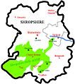
The AONB is highlighted in Green.

