
Southern Illinois facts for kids
Quick facts for kids
Southern Illinois
Little Egypt |
|
|---|---|

Marion, Illinois
|
|

Counties in red are usually or always included in southern Illinois, while those in pink are sometimes included.
|
|
| Country | |
| State | |
| Largest city | Belleville |
| Population | 1.2 million |
Southern Illinois, also known as Little Egypt, is the southern third of Illinois, principally along and south of Interstate 64. Although part of a Midwestern state, this region is aligned in culture more with that of the Upland South than the Midwest. Part of downstate Illinois, it is bordered by the two most voluminous rivers in the United States: the Mississippi below its connecting Missouri River to the west and the Ohio River to the east and south with the Wabash as tributary.
Southern Illinois' most populated city is Belleville at 44,478. Other principal cities include Alton, Centralia, Collinsville, Edwardsville, Glen Carbon, Godfrey, O'Fallon, Harrisburg, Herrin, West Frankfort, Mt. Vernon, Marion, and Carbondale, where the main campus of Southern Illinois University is located. Residents may also travel to amenities in St. Louis and Cape Girardeau, Missouri; Memphis and Nashville, Tennessee; Evansville, Indiana; and Paducah, Kentucky. The region is home to Scott Air Force Base, a major military installation.
The area has a population of 1.2 million people, who live mostly in rural towns and cities separated by extensive farmland and the Shawnee National Forest. The two higher density areas of population are Metro East (pop. 700,000+), which is the partly industrialized Illinois portion of the St. Louis Metropolitan Area, and the Carbondale-Marion-Herrin, Illinois Combined Statistical Area, centered on Carbondale and Marion, a two-county area that is home to 123,272 residents.
The first European settlers were French colonists in the part of their North American empire called Illinois Country. Later settlers migrated from the Upland South of the United States, traveling by the Ohio River. The region was affiliated with the southern agricultural economy, based on enslaved African Americans as workers on major plantations, and rural culture. Some settlers owned slaves before the territory was organized and slavery was prohibited. Many areas developed an economy based on coal mining. Much of Southern Illinois is still culturally affiliated with the Mid-South: Western Kentucky, Southwestern Indiana, West Tennessee, and the Missouri Bootheel. The people speak with similar accents throughout this area. Southern Illinois, the earliest settled and once the wealthiest part of Illinois, is known for its rich history and the abundance of antebellum architecture remaining in its small towns and cities.

History
Early history
The earliest inhabitants of Illinois are thought to have arrived about 12,000 BC. They were hunter-gatherers, but also developed a primitive system of agriculture. After AD 1000, agricultural surpluses enabled them to develop complex, hierarchical societies. With the rise of the Mississippian culture in the Mississippi and Ohio River valleys, tribal leaders organized thousands to build complex urban areas with numerous large earthworks – pyramidal, ridgetop and conical mounds used for religious, political and ceremonial purposes. Cahokia, located in present-day Collinsville, Illinois, was the major regional center of this culture. It contains the largest prehistoric earthworks in the Americas, and has been designated a UNESCO World Heritage Site. The mound builders' culture seems to have collapsed between AD 1400–1500. The Mississippians had abandoned Cahokia long before the first European explorers arrived.
The Illinois Indian tribes, for whom the state is named, and other tribes migrated to Southern Illinois around AD 1500. Archeologists say they were not descendants of the earlier inhabitants. The Illini left numerous artifacts, including burial sites, burned-out campfires along the bases of bluffs, pottery, flint implements, and weapons. Structures built by them include stone forts or "pounds". Visitors can see a stone fort in Giant City State Park near Makanda. At least eight other such structures are known in the region.
In about 1673, French explorers from Quebec became the first Europeans to reach Illinois. The French named the area Illinois after the Indians who had welcomed them. The French explored the Mississippi River, establishing outposts and seeking a route to the Pacific Ocean and the Far East. As increasing Indian unrest and warfare began in Northern Illinois over the lucrative fur trade along the Great Lakes, the French concentrated on building outposts in Southern Illinois. The earliest European settlers were concentrated along the Mississippi, Ohio, and Wabash rivers, which provided easy routes for travel and trade. The settlements became important way stations and supply depots between Canada and the French ports on the lower Mississippi River. Other important early outposts in Southern Illinois were at Old Shawneetown and Fort Massac on the Ohio River.
After defeating the French in the French and Indian War (Seven Years' War) and signing the Treaty of Paris in 1763, the English ruled the Lower Great Lakes region. Their rule of this area was short lived. At the time, many French settlers moved from towns on the eastern side of the Mississippi to the western side, which was ruled by Spain after the war. It took over all the Louisiana Territory west of the river.
Arrival of settlers


European-American settlers were initially slow to arrive in Illinois after the United States victory in the American Revolutionary War. By 1800, fewer than 2,000 European Americans lived in Illinois. Soon more settlers came from the backwoods areas of Kentucky, Tennessee, Virginia, Georgia, and the Carolinas. These early settlers were mostly of English, German, and Scots-Irish descent.
In 1787, the federal government included Illinois in the Northwest Territory, an unorganized area that included present-day Ohio, Indiana, Michigan, and Wisconsin. Slavery was prohibited in this area, but for some time, slaveholders already in the area were allowed to keep their chattel property. As the areas became more populated with European Americans, they could be admitted as states to the Union. Illinois became a part of the Indiana Territory in 1800. Illinois settlers wanted more control over their own affairs and Illinois became a separate territory in 1809. It was admitted as a free state in 1818. In late 1811 and early 1812, the New Madrid earthquakes struck the region as one of the largest successions of earthquakes, including the most intensive ever indirectly inferred (not recorded) in the contiguous United States.
The first bank to be chartered in Illinois was located at Old Shawneetown in 1816. The first building used solely to house a bank in Illinois was built in 1840 in Old Shawneetown and was used until the 1920s. The Old Shawneetown State Bank has been restored as an historical site. Crops of cotton and tobacco were grown in the extreme southern region of Illinois. Cotton was grown mostly for the home weaver, but during the Civil War, cotton was also grown for export, as the regular supply of cotton from the South was not available. Enough tobacco was grown to make it a profitable crop for export. Both crops have been succeeded by other agricultural commodities.
19th century turbulence

A feud between families in Williamson County, called the Bloody Vendetta, lasted nearly ten years and took many lives. In all, 495 assaults with a deadly weapon were committed and 285 murders took place in Williamson County between 1839 and 1876. This was very unusual, as crime was almost non-existent in Illinois during its frontier years prior to this period of lawlessness.
In 1858, Abraham Lincoln ran for the U.S. Senate against Stephen A. Douglas. A debate was held in seven towns in Illinois, one being near Jonesboro. Many of the people living in Southern Illinois were first or second-generation Southerners. Cairo, Illinois, at the southern tip where the Ohio River joins the Mississippi, was of strategic importance. On either side of the rivers were states which, despite remaining in the Union, had numerous residents who were sympathetic to the South. Some leaders in this area had been active in the Knights of the Golden Circle, which proposed a southern pan-Caribbean confederation based on slave states and nations.
The outbreak of the American Civil War drew from the mixed loyalties in this region, and some residents enlisted in the Confederate Army. In June 1861, 34 men from the Southern Illinois counties of Williamson and Jackson traveled to western Tennessee and became part of Company G of the 15th Tennessee Volunteer Infantry, according to "Illinois Rebels – A Civil War Unit History of G Company, 15th Tennessee Regiment Volunteer Infantry" by Ed Gleeson (1996, Guild Press of Indiana, 435 Gradle Drive, Carmel, Indiana 46032). The Union Army also used Cairo as a staging area for its expeditions into the border states of Missouri and Kentucky, and also the Confederate states of Tennessee and Mississippi.
Rise and fall during the 20th century
Coal mining became an important industry in Southern Illinois around the start of the 20th century, with cities such as Harrisburg prospering, having a population of 16,000 people during the 1920s. Union miners all over the nation went on strike in 1922; during this period, 20 men were killed during a riot in Herrin, in Williamson County. It was called the Herrin Massacre, and the county was known as Bloody Williamson for years to come.
The Shelton Brothers Gang and Charles Birger gangs operated in Southern Illinois in the 1920s during Prohibition. Shoot-outs between these and other rival gangsters and with law enforcement officers were common. After being convicted of ordering the murder of the mayor of West City, the leader of the Birger gang, Charlie Birger, was hanged in 1928. In 1925 the Tri-State Tornado was the deadliest on record, devastating the city of Murphysboro and killing 234 people, the most in a single city in U.S. history.
The Wall Street Crash of 1929 and the Great Depression of the 1930s caused coal miners to lose their jobs as most mines closed. Farmers could not sell their crops and lost their land; families defaulted on home mortgage loans; and young people from the region began leaving for the cities to find work. After World War II, employment started to rise within the region, but unemployment continued to be a problem for the rural region for decades afterward. When the Clean Air Act of 1990 required many utility companies in the United States to switch to low-sulfur coal for the health of the nation, lacking affordable technology to clean the coal, the Southern Illinois region lost markets and the economy suffered. Agriculture has since become the main economic driver for the Southern Illinois region.
Southern Illinois is slowly gaining a cultural identity apart from its neighbors, as previously-dispersed rural populations become more concentrated around the cities of Marion and Belleville. Marion has grown tremendously since 1970 and in the process has been selected for Illinois' first STAR Bonds District for the Millennium Development, a project originally designed for a city ten times its size.
Population among the smaller cities and towns have dropped significantly as people moved to the Carbondale-Herrin-Marion combined statistical area and Metro East.
Origin of "Little Egypt" name

The nickname "Egypt" may have arisen in the 1830s, when poor harvests in the north of the state drove people to Southern Illinois to buy grain. Others say it was because the land of the great Mississippi and Ohio River valleys were like that of Egypt's Nile delta. According to Hubbs,. Today, the town of Cairo still stands on the peninsula where the Ohio River joins the Mississippi.
Other settlements in the area were also given names with Egyptian, Greek or Middle Eastern origins: The Southern Illinois University Salukis sports teams and towns such as Metropolis, Thebes, Dongola, Palestine, Lebanon, New Athens Sparta, and Karnak show the influence of classical culture. (Greek names were also related to the contemporary national pride in the new republic of the early 19th century, and were given to towns throughout the Midwest.) Egyptian names were concentrated in towns of Little Egypt but also appeared in towns further south. For instance, about 100 miles (200 km) south of Cairo, along the Mississippi, lies Memphis, Tennessee, named after the Egyptian city on the Nile.
Although Illinois was a free state prior to the American Civil War, some residents in Little Egypt still owned slaves. Illinois law generally forbade bringing slaves into Illinois, but a special exemption was given to the salt works near Equality. In addition, an exception was made for slaveholders who held long-term indentured servants or descendants of slaves in the area before it achieved statehood.
The nicknames for this region also arose from the political tensions prior to and during the American Civil War, as regions of the state allied differently with North and South. Because southern Illinois was settled by southerners, they maintained a sympathy for many issues of their former states. They supported the continuation of slavery and voted for Democrats at a time when the northern part of the state supported Republicans. The meaning is expressed in this description of the 1858 campaign of Douglas and Abraham Lincoln:
"In 1858, debating in northern Illinois, Douglas had threatened Lincoln by asserting that he would 'trot him down to Egypt' and there challenge him to repeat his antislavery views before a hostile crowd. The audience understood Douglas: overwhelming proslavery sentiment and Democratic unanimity in Egypt had led to the nickname."
In the fall of 1861, Democrats took a majority of seats in the state legislature. They worked to pass provisions of a new constitution, an initiative begun in 1860. They proposed reapportionment so the southern region's less populous counties would have representation equal to those in the north, which was growing more rapidly. Northern Illinois residents worried about the state coming under the political will of the southern minority. "Shall the manufacturing, agricultural and commercial interests of northern Illinois be put into Egyptian bondage?" wondered the Aurora Beacon." When Lincoln commissioned the Southern Illinois Democrat, John Alexander McClernand, as a brigadier general, he told him to "keep Egypt right side up".
In addition, southern Illinois had become the center of the Knights of the Golden Circle, a secret group devoted to supporting the Confederacy. With concern rising about armed southern sympathizers, in August 1862, U.S. Marshal David Phillips arrested several Democrats who allegedly belonged to the Knights, including men in respectable positions: Congressmen, state representatives, and judges. One was Circuit Judge Andrew Duff. They were sent to Washington, DC, where they were held for 68 days before release, but they were never charged. Democrats won across the state in the fall election.

After the war, other reasons were proposed for the nickname. Political divisions continued in the state. In the later 19th century, the central and southern agricultural areas joined the Populist Movement. Chicago and the industrial North aligned with similar areas and continued as predominantly Republican into the 20th century.
In 1871 Judge Andrew Duff wrote an article in which he ignored the war years and preceding political divisions. He claimed the name of Egypt related to Southern Illinois' role in supplying grain to northern and central Illinois following the "Winter of the Deep Snow" in 1830–31. Following a long winter and late spring, Upper Illinois lost much of its harvest in an early September frost. Southern Illinois's weather gave it good crops, so it could ship grain and corn north. The nickname supposedly arose from similarities of the events to the well-known Bible story of Jacob's sons going to Egypt for grain to survive a famine.
Belly dancer Farida Mazar Spyropoulos' appearance as "Little Egypt" at the 1893 World's Columbian Exposition in Chicago brought notoriety to the name, but she had no connection to the Illinois region. Other dancers took up the stage which popularized it further in the early 20th Century.
One of the earliest uses of the phrase "Little Egypt" is found in the Troy Weekly Call of Troy, Illinois, in 1912. A state news brief was headlined, "Two New Little Egypt Pastors." about two new Presbyterian pastors about to be installed at Brookport and Salem, Illinois. The Chicago Tribune appears to have first used the phrase "Little Egypt" in reference to Southern Illinois on 25 April 1920 in an article about fruit grown in the region. The title character in the comic strip "Moon Mullins" had a girlfriend named Little Egypt. The strip's creator Frank Willard, was a native of Anna and Southern Illinois.
Microregions

Northern boundary
"Southern Illinois" is not a formal geographic designation and definitions of what constitutes Southern Illinois vary. Many Southern Illinois residents consider an area between Interstate 70 and Interstate 64 as the dividing line between the Central and Southern parts of the state. The geography of Illinois becomes gradually hillier as one travels farther South. One can see this driving south along Interstate 57. The Mattoon/Charleston area is fairly flat. Terrain becomes noticeably less flat as one gets to Effingham, but it is still level enough to support the vast corn and soybean fields that are so common in the rest of Central Illinois. South of Effingham on the interstate, one sees more trees and terrain that is too hilly for most large farms.
Metro East

The most populous region of Southern Illinois is the Illinois side of the St. Louis Metropolitan Statistical Area. Noted areas are Cahokia Mounds, the American Bottom, and East St. Louis, which has had a turbulent history related to industrialization and labor, immigration and the struggle for equal rights.

- Population: 702,579
|
Counties |
Principal cities |
City populations
|
East-Central Southern Illinois

Located on the Wabash River, East-Central Southern Illinois is noted by the town of Salem, the birthplace of William Jennings Bryan, the G. I. Bill of Rights and Miracle Whip salad dressing.
- Population: 121,746
|
Counties |
Principal cities |
City populations
|
West-Central Southern Illinois


Chester Illinois within West-Central Southern Illinois is noted as the "Home of Popeye", where many of the influences for the characters were located. Kaskaskia, the first state capital of Illinois is located near the Mississippi River. This area also contains the ending point of the Kaskaskia River near the Fort Kaskaskia State Historic Site. Rend Lake is located in this area.
- Population: 148,930
|
Counties |
Principal cities |
City populations
|
Southwest Illinois
Located within the western reaches of the Cache River, Southwest Illinois is the second most populated region. The region's most notable institution is the main campus of Southern Illinois University in Carbondale, winner of the 1971 All-America City Award, finalist in the 2009 contest, and the fastest growing city in Southern Illinois outside the Metro-East, Marion, Illinois. Both cities are centered in the Carbondale-Marion-Herrin, Illinois Combined Statistical Area, home to 123,272 residents. In the southern reaches of the region Alto Pass and Bald Knob Cross are located near the orchards. The large Crab Orchard lake is the largest in the region. Historic Cairo sits to at the far southern end near the confluence of the Ohio and Mississippi Rivers.
- Population: 158,782
|
Counties |
Principal cities |
City populations
|
Southeastern Illinois

The least populated region, Southeastern Illinois is marked by being within the Shawnee Hills and the Shawnee National Forest. The area includes many state parks such as Garden of the Gods Wilderness. The historic town of Shawneetown is located on the Ohio River which is the eastern border of the region. The northern reaches of Southeastern Illinois include the Harrisburg Coal field, which are roughly 200 square miles (500 km2) of abandoned coal mines dating to around the start of the 20th century near Harrisburg, Illinois, the largest city in the Southeastern Illinois area. The Saline River forks through the region as well.
- Population: 90,425
|
Counties |
Principal cities |
City populations
|
Geography
Illinois has been partially covered at times by continental ice sheets. Specifically, Southern Illinois was only partially covered by continental ice sheet during the Illinoian Stage and not at all during the Wisconsin Stage. Thus, the geography of Southern Illinois is considerably more hilly and rocky than central or northern Illinois. Areas of Southern Illinois are more similar to the Ozarks than to central or northern Illinois.

Additionally, the rich farm land of northern and central Illinois is generally not found in Southern Illinois. Significant exceptions are the American Bottom along the Mississippi River and the alluvial soils of the Gulf Coastal Plain, a large region that has its northernmost extent in the two river valleys of Southern Illinois.
The region's other major river, the Ohio River, winds generally southwest, past Shawneetown, Cave-in-Rock, Elizabethtown, and Golconda. Its waters join the Mississippi at Cairo. In ancient times, the Ohio is thought to have flowed a more northerly course through Pope and Pulaski counties. It carved a broad valley there, fit for a major river. But today the underfit Bay Creek and Cache River occupy those valleys.
The hills of Little Egypt can be divided into two areas. The western area, more closely related to the Ozarks of Missouri, is chiefly in southern Jackson, Union, northern Alexander and Johnson counties. The eastern area, more closely related to the Wabash Valley Seismic Zone, is mostly in northern Pope, southern Saline, Gallatin, eastern Johnson and southern Williamson counties. The Shawnee National Forest covers a large territory, including seven wilderness areas: Garden of the Gods, Bay Creek, Clear Springs, Bald Knob, Burden Falls, Lusk Creek, and Panthers Den.
Of southern Illinois' rivers, only the Mississippi and the Ohio are navigable for modern commerce. The Big Muddy River, Marys River, Saline River and Cache River run their courses in deep southern Illinois. The Kaskaskia River and Wabash River are nearby.

Shawnee National Forest
More than 270,000 acres (1100 km²) of Shawnee National Forest lie to the south of its gateway city Harrisburg. The Shawnee National Forest offers much to see and do. The national forest has 1,250 miles (2,010 km) of roadways, some 150 miles (240 km) of streams and frequent waterfalls, numerous ponds and lakes as large as 2,700 acres (11 km²) (some with swimming beaches), 13 campgrounds, many picnicking sites, and seven wilderness areas where trails are designed for hiking and horseback riding.
Plant life is extremely diverse and ranges from sun-loving species to those that grow in dense shade. Tree cover dominates the publicly owned land, and is a significant component on privately owned lands. Oak-hickory is the predominant timber type, however, many other commercially important timber species also occupy significant land. More than 500 wildlife species can be found in the Forest, including 48 mammals, 237 birds, 52 reptiles, 57 amphibians, and 109 species of fish. There are seven federally listed threatened and endangered species that inhabit the Forest, as well as 33 species which are considered regionally sensitive, and 114 Forest-listed species.
Climate


Southern Illinois lies on the border between humid continental climate (Köppen climate classification Dfa) and humid subtropical climate (Köppen climate classification Cfa). The region has neither large mountains nor large bodies of water to moderate its temperature and, thus, it is subject to both cold Arctic air and hot, humid tropical air from the Gulf of Mexico and, along with the rest of the midwestern United States, is home to some of the largest temperature extremes in the world. The region has four distinct seasons. Spring is the wettest season and produces erratic severe weather ranging from tornadoes to winter storms. Summers are hot and humid with only occasional and brief respite, and the humidity often makes the heat index rise to temperatures feeling well above 100 °F (38 °C). Fall is mild with lower humidity and can produce intermittent bouts of heavy rainfall with the first snow flurries usually forming in late November. Winters are cold with periodic snow and temperatures often below freezing, however thaws are usually frequent. Winter storm systems, such as Alberta clippers and Panhandle hooks, can bring days of heavy freezing rain, ice pellets, and snowfall.
Despite the four distinct seasons, Southern Illinois supports a small amount of cold-hardy palm trees, that can be found sparingly throughout the region. These palms are among the northernmost naturally occurring palms within the continental United States, away from moderate climates provided by the coasts.
The normal high temperature in July is 90 °F (32 °C), and the normal low temperature in January is 21 °F (−6 °C), although this varies from year to year. Both 100 °F (37.8 °C) and 0 °F (−17.8 °C) temperatures can be seen on an average 2 or 3 days per year. The official record low is −23 °F (−31 °C) on February 2, 1884 in Harrisburg, and the record high is 117 °F (47 °C) on July 14, 1954 in East St. Louis.
Southern Illinois experiences thunderstorms about 50 days a year on average. Thunderstorms contribute over half of the annual precipitation. Especially in the spring, these storms can often be severe, with high winds, large hail and tornadoes. Southern Illinois has been affected on more than one occasion by particularly damaging tornadoes.
A period of warm weather late in autumn known as Indian summer can occur – roses will still be in bloom as late as November or early December in some years.
Seismic zones


Southern Illinois sits upon the verging point of two major fault systems, the New Madrid Seismic Zone and the Wabash Valley Seismic Zone. In the 1970s after the 5.4 Richter magnitude scale 1968 Illinois earthquake, scientists realized that there was an unknown fault under Saline County, just north of Eldorado, Illinois. This fault is called the Cottage Grove Fault, a small tear in the Earth's rock, in the Southern Illinois Basin. Seismographic mapping completed by geologists reveal that monoclines, anticlines, and synclines are present within the region; these signs suggest deformation during the Paleozoic, coincident to strike-slip faulting nearby.
A fault plane solution of the earthquake confirmed two nodal planes both striking north-south and dipping approximately 45 degrees to the east and to the west. This faulting suggests dip slip reverse motion, and to a horizontal east-west axis of confining stress. Although there are no confirmed faults in the immediate epicentral region, the motion indicated corresponds to that along the Wabash Valley Seismic Zone roughly 10 miles (20 km) east of the region, responsible for the 2008 Illinois earthquake. The rupture also occurred partially on the New Madrid Fault, responsible for the great New Madrid earthquakes in 1812, consisting of the most powerful earthquakes to hit the contiguous United States.
Transportation
Passenger rail
Southern Illinois at one time had an extensive network of railroads. Now only Amtrak, the U.S. passenger rail system, provides service to and through the area. Carbondale is served with three trains daily to and from Chicago, and one train daily to and from Memphis and New Orleans. Several trains each day run to and from Chicago and St. Louis, with Alton the major stop in Southern Illinois.

The St. Louis MetroLink is the light rail transit system in the Greater St. Louis area of Missouri and Illinois connecting the Metro East to downtown St. Louis. The entire system currently consists of two lines (Red Line and Blue Line) connecting Lambert-St. Louis International Airport and Shrewsbury, Missouri with Scott Air Force Base near Shiloh, Illinois, through downtown St. Louis. The system features 37 stations and carries an average of 61,573 people each weekday.
Interstate freeways
The Metro East area near St. Louis has these additional freeways:
 Interstate 55
 Interstate 70
 Interstate 255
 Interstate 270
Southern Illinois has 4 major interstate freeways that connect with Missouri, Indiana, and Kentucky. Depending on the definition of Little Egypt's boundaries, there are four interstates in the region. I-57 is the main north–south freeway through Southern Illinois. It runs through the center of the area. South of Marion is the western terminus of I-24. It runs southeast, crossing into Paducah, Kentucky near Metropolis. South of its junction with I-24, I-57 bends to the southwest and crosses into Missouri near Illinois' southernmost point by Cairo. I-70 runs east–west from St. Louis to central Indiana. I-64 runs east–west from St. Louis to southern Indiana. It is cosigned with I-57 for a short stretch at Mt. Vernon. I-57 is responsible for much of the growth found around the city of Marion.
 Interstate 24
 Interstate 57
 Interstate 64
U.S. highways
- U.S. Route 40
- U.S. Route 45 runs from the Brookport Bridge across the Ohio River east of Paducah, Kentucky, and through Shawnee National Forest. Saline County, Illinois is its most populated stretch in Southern Illinois, connecting the towns of Stonefort, Carrier Mills, Harrisburg, and Eldorado, all within the county. The highway continues north through the Chicago metropolitan area and to the Wisconsin border east of Antioch. With a length of 428.99 miles (690.39 km) in Illinois, U.S. 45 is the longest numbered route in Illinois.
- U.S. Route 50
- U.S. Route 51 roughly follows the Illinois Central Railroad line north–south through the middle of the entire state. Illinois Route 1 runs north–south along the eastern edge of Little Egypt; Illinois Route 3 parallels the Mississippi River along the western edge of the area.
- U.S. Route 60
- U.S. Route 62
- Historic U.S. Route 66
- U.S. Route 67
State highways
|
|
|
|
Bridges and ferries


Bridges and ferries are an important feature in the region, being it is surrounded on three sides by major rivers, the Ohio and Wabash rivers to the east and south, and the Mississippi River to the west.
Indiana:
- Red Skelton Memorial Bridge at Vincennes, Indiana, carries U.S. 50/150 to Lawrenceville, Illinois
- Lincoln Memorial Bridge, a deck arch bridge carrying Business U.S. Route 50 over the Wabash River between Vincennes, Indiana and Lawrence County, Illinois
- Wabash Cannonball Bridge at St. Francisville, carries a farm road from Knox County, Indiana to Lawrence County, Illinois
- Mount Carmel Bridge at Mount Carmel, carries IL 15/IN 64
- Interstate 64 Bridge, located 2 mi (3.2 km) south of Grayville, Illinois between Posey County, Indiana, Gibson County, Indiana, and White County, Illinois.
- New Harmony Bridge, toll bridge that formerly carried IL 14/IN 68
- Wabash Memorial Bridge, spans the Wabash River between Indiana State Road 62 and Illinois Route 141, east of New Haven, continues to Evansville, Indiana
Kentucky:
- Illinois Route 13 at Old Shawneetown, Illinois
- Brookport Bridge, U.S. Route 45 at Brookport, Illinois
- Interstate 24 Bridge near Brookport/Metropolis
- Cairo Ohio River Bridge, U.S. Route 51/60/62 near Cairo, Illinois and Wickliffe, Kentucky
Missouri:
- Cairo Mississippi River Bridge, a cantilever bridge carrying U.S. Route 60 and U.S. Route 62 across the Mississippi River between Bird's Point, Missouri and Cairo, Illinois.
- Cairo I-57 Bridge, an arch bridge carrying 4 lanes of Interstate 57 across the Mississippi River between Charleston, Missouri and Cairo, Illinois
- Bill Emerson Memorial Bridge, a cable-stayed bridge connecting Missouri's Route 34 and Route 74 with Illinois Route 146 across the Mississippi River between Cape Girardeau, Missouri and East Cape Girardeau, Illinois
- Chester Bridge, a truss bridge connecting Missouri's Route 51 with Illinois Route 150 across the Mississippi River between Perryville, Missouri and Chester, Illinois
Mississippi River in the St. Louis area:
- Clark Bridge, a cable-stayed bridge between West Alton, Missouri and Alton, Illinois, carries U.S. Route 67
- Eads Bridge, combined road and railway bridge over the Mississippi River, connecting St. Louis and East St. Louis
- Jefferson Barracks Bridge, a pair of bridges that span the Mississippi River on the south side of St. Louis, Missouri, that carry traffic for Interstate 255 and U.S. Route 50
- Martin Luther King, Jr. Bridge, carries 3 lanes (1 westbound and 2 eastbound) of Route 799 between St. Louis and East St. Louis
- McKinley Bridge, steel truss bridge connecting northern portions of St. Louis with Venice, Illinois
- New Chain of Rocks Bridge, a pair of bridges, currently carries traffic for Interstate 270, near Granite City, Illinois and Bellefontaine Neighbors, Missouri
- Poplar Street Bridge, carries Interstate 55, Interstate 64, and U.S. Route 40 across the Mississippi between St. Louis and East St. Louis
- Stan Musial Veterans Memorial Bridge began carrying Interstate 70 between St. Clair County, Illinois, and St. Louis in 2014.
A free ferry crosses the Ohio River at Cave-in-Rock. A toll ferry crosses the Mississippi at Ste. Genevieve, Missouri, near Chester, Illinois. Four other ferries operate in Calhoun County.
Airports
- Benton Municipal Airport
- Carmi Municipal Airport
- Centralia Municipal Airport
- Effingham County Memorial Airport
- Fairfield Municipal Airport (Illinois)
- Harrisburg-Raleigh Airport
- Lawrenceville-Vincennes International Airport
- Metropolis Municipal Airport
- MidAmerica St. Louis Airport / Scott Air Force Base
- Mount Vernon Airport
- Pinckneyville-DuQuoin Airport
- Southern Illinois Airport
- Sparta Community Airport (Hunter Field)
- St. Louis Downtown Airport
- St. Louis Metro-East Airport
- St. Louis Regional Airport
- Williamson County Regional Airport
Out of state airports
- Barkley Regional Airport
- Cape Girardeau Regional Airport
- Evansville Regional Airport
- Lambert-St. Louis International Airport
- Spirit of St. Louis Airport
Historical politics
Southern Illinois has historically been a conservative Democratic region. Even as the political parties have changed, Southern Illinois has consistently voted for Democratic candidates more times than not since 1818. Democratic roots in Southern Illinois relate to the region's shared culture with the South, where the Democratic Party before the American Civil War and after Reconstruction was dominant until the 1960s. Democratic affiliations were strengthened during the Great Depression and Franklin D. Roosevelt's administration.
However within the last decades, Southern Illinois has trended GOP due to nationwide support for the GOP among rural areas, while Northern Illinois due to outward migration from Democratic-leaning Cook county has trended Democratic. Democratic candidates were competitive in the counties of Southern Illinois until around 1996. Beginning as recently as the presidential election of 2000, Democrats have under-performed in Southern Illinois despite winning Illinois consecutively.
In the early months of the Civil War, some residents in Williamson County voted for secession from the Union. On April 15, 1861 the citizens of Marion passed a resolution calling for the division of Illinois and the secession of Southern Illinois. The resolution was soon repealed, but General Benjamin Prentiss left a company of men near Marion for defense as he passed by on his way to a garrison in Cairo. Despite some southern sympathizers, most young men in the region joined the Union Army,
Culture
Culturally, Southern Illinois draws influences from the rest of Illinois but also from neighboring Missouri and Upper Southern states like Kentucky and Tennessee. The immigration route from the east coast ran along the Ohio River, which joined settlements on both sides. In addition, the Cumberland River flowed northwest through Kentucky and Tennessee before joining the Ohio near Paducah, Kentucky, affording a migration route from the interior of those states. Thus, settlers who came to Southern Illinois were from Virginia, Kentucky, and Tennessee, with most of these being of northern English and Scots-Irish descent, who formed the last major migration from the British Isles to the colonies before the Revolutionary War, and settled mostly in the backcountry. Some migrated further west into Missouri. A road between Golconda and Jonesboro carried settlers and commerce across Southern Illinois, as well as the Cherokee on the Trail of Tears.
Little Egypt exists at the confluence of the North Midland and South Midland dialects of American English. South Midland becomes more prominent as one approaches the Ohio River. The dialect change is not a continuum, but rather occurs in pockets, with certain towns and regions notably favoring one dialect over the other. This difference can be found between lifelong residents of the same town. No stigma is associated to either dialect within southern Illinois. According to David Hackett Fischer in his book Albion's Seed: Four British Folkways to America, the dialect of this region is Southern Highland. It was derived from the linguistics of the people of the Southern Appalachian region. This is consistent with the majority of the early settlers of this region migrating from the Upper South. The older term for this type of dialect was "Scotch-Irish" speech (the correct term today is Scots-Irish.)
Tourism
Southern Illinois prides itself in tourism as a quaint rural area. There are many state parks in the area, benefiting from the scenery of the Shawnee National Forest. Also Southern Illinois is the oldest part of the state so there are many historical landmarks to be seen in the area, with numerous historical markers dotting the counties.
Casinos
- Argosy Casino (Alton)
- Harrah's (Metropolis)
- Casino Queen (East St. Louis)
Wineries and orchards
List of wineries in Illinois
| Winery / Orchard | Location |
|---|---|
| * Alto Vineyards | Alto Pass |
| * Bella Terra Winery | Creal Springs |
| * Blue Sky Vineyards | Makanda |
| * Boyd's Orchards | Anna |
| * Bremer's Orchard | Metropolis |
| * Cache River Basin Vineyard & Winery | Belknap |
| * Eastman Orchard and Fruit Market | Goreville |
| * Flamm's Orchard & Fruits | Cobden |
| * GenKota Winery | Mt. Vernon |
| * Hawkins/Schwartz Orchard | Dix |
| * Hedman Orchard & Vineyards/Peach Barn | Alto Pass |
| * Hogg Hollow Winery | Glendale |
| * Inheritance Valley Vineyards | Alto Pass |
| * Limestone Creek Winery | Jonesboro |
| * Lincoln Heritage Winery | Cobden |
| * Owl Creek Vineyard | Cobden |
| * Pheasant Hollow Winery | Whittington |
| * Rendleman Orchards Farm Market | Alto Pass |
| * Rustle Hill Winery | Cobden |
| * Shawnee Winery | Vienna |
| * Starview Vineyards | Cobden |
| * Uncorked Tours | Alto Pass |
| * Von Jakob Vineyards | Alto Pass |
| * Windy Hill Vineyard & Winery | Creal Springs |
=
Economy
There are two main centers of commerce for Southern Illinois. They consist of the St. Louis, Missouri metropolitan area (home to approximately 2.8 million people), and the Carbondale, Marion, Herrin, Harrisburg area (home to approximately 245,000 people).
The main agricultural products of Southern Illinois are crops such as corn and soybeans. Apples, peaches, grapes, are commonly found throughout Southern Illinois as well as the occasional sunflower, cotton, wheat, hay, and milo fields. In recent years there has been development of wineries in the Shawnee Hills region. Additional growth has occurred with the local foods movement as Southern Illinois' climate allows for fruit and vegetable production. Southern Illinois is also the home to aquaculture, beef, swine, equine, sheep, goats, and other livestock production. Agricultural efforts in the region are greatly aided by a small University of Illinois Extension research station near Dixon Springs and extensive research from Southern Illinois University – Carbondale's College of Agricultural Sciences. SIUC is home to the state's only non-land grant research-focused university with an agricultural college which provides practical research to the scientific and agricultural communities both in Southern Illinois as well as the rest of the state and the broader region.
Southern Illinois also has significant coal deposits; however, since the late 1980s, the coal industry has suffered significant decline due to the decreased demand for high-sulfur coal, which causes more pollution. The collapse of the coal industry had profound and lasting impact on the region's economy. With the introduction and application of scrubber technology at power plants, demand for high-sulfur has made a return in the 2010s.

The Illinois oil basin is located mostly in Little Egypt. During the early 1940s and 1950s, Little Egypt had a modest oil boom in towns such as Carmi, McLeansboro, and Lawrenceville. Oil production reached more than 140,000,000 barrels (22,000,000 m3) per year in the 1940s, but dropped to 10,000,000 barrels (1,600,000 m3) per year by 1995. Oil wells in the region have relatively low yield and produce oil with a high sulfur content, making it expensive to process. There has been no significant drilling activity in the basin since the late 1970s.
Manufacturing in Southern Illinois is typically clustered in the largest towns of each county, with the people of smaller towns and villages often commuting to work in the factories. Many of these towns have a number of light factories and other industrial facilities in their industrial parks. Products include industrial electronics, minor electrical items, automobile parts, and packaging materials. Related services include large-scale printing as well as transportation and distribution of warehoused materials and goods. A high percentage of local jobs are in these light industries.
Images for kids
-
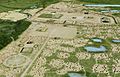
Artist's recreation of central Cahokia near East St Louis in St Clair County
-
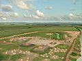
Artist's representation of the Kincaid Site on the Ohio River in Massac County, as it may have looked during its peak
-
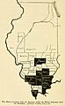
The majority of Illinois voters in 1824 rejected a proposal for a new constitutional convention that could have made slavery legal outright. A map of Illinois free And slave counties in 1824 showing shaded counties that were favorable to legalizing slavery in Illinois
-

A statue in Carbondale.
-
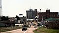
Harrisburg skyline. Harrisburg prospered with one of the largest Southern Illinois downtown districts during the 1920s and had a population of nearly 16,000 people. Today it has a population of about 9,000.
-

Aerial of Jameson Island in the Big Muddy, view looking south.
-

The cave at Cave-in-Rock State Park


