
Southmead facts for kids
Quick facts for kids Southmead |
|
|---|---|
 Boundaries of the city council ward |
|
| Population | 11,956 (2011.Ward) |
| OS grid reference | ST582785 |
| Unitary authority | |
| Ceremonial county |
|
| Region | |
| Country | England |
| Sovereign state | United Kingdom |
| Post town | BRISTOL |
| Postcode district | BS10 |
| Dialling code | 0117 |
| EU Parliament | South West England |
| UK Parliament |
|
Southmead is a northern suburb and council ward of Bristol, in the south west of England. The town of Filton (in South Gloucestershire), and the Bristol suburbs of Monks Park, Horfield, Henleaze and Westbury on Trym lie on its boundaries.
The River Trym rises in Southmead and flows south west through Badock's Wood, a Local Nature Reserve. There is a round barrow near the northern end of the wood. A Site of Special Scientific Interest, known as the Pen Park Hole, is also located within Southmead on 'Pen Park Road'.
History
Southmead was a manor of the parish of Westbury on Trym. The manor house, mentioned in a document of 1319, was near the south end of what is now Southmead Road. Most of the estate of 313 acres (1.27 km2) was sold in the late 19th century. By 1888 Southmead was a small hamlet on Southmead Road. Southmead Hospital, formerly the Barton Regis Workhouse, was opened there in 1924.
Large-scale development of the area started in 1931, when the Bristol Corporation built 1,500 houses to the north of Southmead Road, partly to house families cleared from the slums of central Bristol, and partly to address the housing shortage at the time. A further 1,100 houses were built after World War II. Since then, reference has often been made to the "pre-war estate" of Southmead and the "post-war estate".
Southmead today
The centre of Southmead is along Greystoke Avenue, a wide road with grassy areas some distance to the North of the original hamlet on Southmead Road. The area to the South and West, falls within Westbury-on-Trym and Henleaze ward since the last boundary review and further to the May 2016 elections. Parts of Southmead to the South East of Southmead Road, including the hospital, are in Horfield ward.

Social issues
Efforts have been made to improve the area's social problems and implement environmental improvements, many of which have been successful. Social policies have led to a more mixed housing offer and to some extent gentrification, with improved infrastructure and local services. The right to buy has led to an increased transfer of housing provision from tenanted to owner-occupation. Major employment hubs at Filton, MOD Abbey Wood and the increase of services at Southmead Hospital have brought increased affluence and opportunity to the area. A greater selection of shops and facilities have come to the area, allowing those on limited incomes to access food more cheaply and readily. Whilst Southmead as an area looks and feels as though it is improving, it still experiences deprivation. The Central part of Southmead still sits within the most 10% deprived areas of England, and the South West of the Ward since 2015 now falls within the bottom 10-20% most deprived areas. Ongoing social policies and economic impacts are taking time to incrementally improve the area.
Residents have good geographical access. There has however been a transfer of public services away from physical resources to more central, virtual and internet based services. For example the Southmead Police Station is due to close, with a more regional hub at Patchway. Council tenant services are to be reduced at Southmead House off Greystoke Avenue. Bus services, whilst sometimes locally critiqued, are accessible and more frequent as compared to some other areas of the City. A frequent service connects residents to the Gloucester Road area, City Centre and Cribbs Causeway for shopping. The nearest station is however 2–3 miles away at Filton Abbey Wood.
There is good provision of health services with a doctor's surgery on Ullswater Road and a modern new facility at the Greenway Centre. A regional hospital, and A&E facility can be found at Southmead Hospital. The Lannercost provides facilities for those with physical and learning impairments. There are a selection of care homes and sheltered accommodation about the ward area. Despite access to health facilities Southmead still has poor health outcomes; with life expectancy at 77 years, some 5 yrs lower than neighbouring Henleaze but not quite as bad as some areas such as the Bedminster at 76.4 years.
The area is well served with a range of local parks and sporting facilities. There is a private member's sports club at David Lloyd near Badock's Wood. There are sports pitches at Greenway Centre to the South East, and at Charlton Mead to the East of the area. Filton Golf Course abutts Southmead to the North East. There is an excellent MUGA and Adventure Playground off Doncaster Road. There are also play areas off of Glencoyne Square, Charlton Mead and off Greystoke Avenue. To the South of Southmead, only a mile away, is Horfield Sports Centre with public access to 3G pitches, gym, sports Hall and an excellent swimming pool.
There is ready access to children's provision through a selection of primary schools at Baddocks Wood, Little Mead and Fonthill. Baddocks Wood Children Centre complements Early Year's provision to the South of the area. Young people are however said to be more socially deprived and not as likely to go to university as others in the country which is reflective of the national socio-economic imbalances within the UK's education system.
Images for kids
-
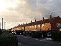
Southmead housing developments
-
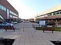
Pedestrian entrance to Southmead Hospital

.jpg)
