
Splashdown facts for kids


Splashdown is the method of landing a spacecraft by parachute in a body of water. It was used by crewed American space capsules prior to the Space Shuttle program, by SpaceX Dragon and Dragon 2 capsules and by NASA's Orion Multipurpose Crew Vehicle. It is also possible for the Russian Soyuz spacecraft to land in water, though this is only a contingency. The only example of an unintentional crewed splashdown in Soviet history is the Soyuz 23 landing.
As the name suggests, the capsule parachutes into an ocean or other large body of water. The properties of water cushion the spacecraft enough that there is no need for a braking rocket to slow the final descent as is the case with Russian and Chinese crewed space capsules (while Shenzhou designed a raft and balanced capsule in case of splashdown), which return to Earth over land. The American practice came in part because American launch sites are on the coastline and launch primarily over water. Russian launch sites are far inland and most early launch aborts were likely to descend on land.
Missions

The splashdown method of landing was used for Mercury, Gemini and Apollo (including Skylab, which used Apollo capsules). Soyuz 23 unintentionally landed on a freezing lake with slushy patches of ice during a snowstorm.
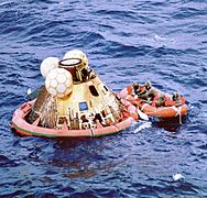
On early Mercury flights, a helicopter attached a cable to the capsule, lifted it from the water and delivered it to a nearby ship. This was changed after the sinking of Liberty Bell 7. All later Mercury, Gemini and Apollo capsules had a flotation collar (similar to a rubber life raft) attached to the spacecraft to increase their buoyancy. The spacecraft would then be brought alongside a ship and lifted onto deck by crane.
After the flotation collar is attached, a hatch on the spacecraft is usually opened. At that time, some astronauts decide to be hoisted aboard a helicopter for a ride to the recovery ship and some decided to stay with the spacecraft and be lifted aboard ship via crane. All Gemini and Apollo flights (Apollos 7 to 17) used the former, while Mercury missions from Mercury 6 to Mercury 9, as well as all Skylab missions and Apollo-Soyuz used the latter, especially the Skylab flights as to preserve all medical data. During the Gemini and Apollo programs, NASA used MV Retriever for the astronauts to practice water egress.
Apollo 11 was America's first Moon landing mission and marked the first time that humans walked on the surface of another planetary body. The possibility of the astronauts bringing "Moon germs" back to Earth was remote, but not impossible. To contain any possible contaminants at the scene of the splashdown, the astronauts donned special Biological Isolation Garments and the outside of the suits were scrubbed prior to the astronauts being hoisted aboard USS Hornet and escorted safely inside a Mobile Quarantine Facility.
Both the SpaceX Dragon and Dragon 2 capsules were designed to use the splashdown method of landing. The original cargo Dragon splashed down in the Pacific Ocean off the coast of Baja California. At the request of NASA, both the crew and cargo variations of the Dragon 2 capsule splashes down off the coast of Florida, either in the Atlantic Ocean or the Gulf of Mexico.
The early design concept for the new U.S. Orion Crew Exploration Vehicle featured recovery on land using a combination of parachutes and airbags, although it was also designed to make a contingency splashdown (only for an in-flight abort) if needed. Due to weight considerations, the airbag design concept was dropped. The present design concept features landings via splashdown in the Pacific Ocean off the coast of California.
Disadvantages
The most dangerous aspect is the possibility of the spacecraft flooding and sinking. For example, when the hatch of Gus Grissom's Liberty Bell 7 capsule blew prematurely, the capsule sank and Grissom almost drowned.
Since the spacecraft's flooding will occur from a location in its hull where it ruptures first, it is important to determine the location on the hull that experiences the highest loading. This location along the impacting side is determined by the surrounding `air cushion' layer, which deforms the water surface before the moment of impact, and results in a non-trivial geometry of the liquid surface during first touch-down.
If the capsule comes down far from any recovery forces, the crew are exposed to greater danger. As an example, Scott Carpenter in Aurora 7 overshot the assigned landing zone by 400 kilometers (250 mi). These recovery operation mishaps can be mitigated by placing several vessels on standby in several different locations, but this is quite an expensive option.
Locations
Crewed spacecraft
| # | Spacecraft | Agency | Landing date | Coordinates | Recovery ship | Miss distance (km) | Reference |
|---|---|---|---|---|---|---|---|
| 1 | Freedom 7 | NASA | May 5, 1961 | 27°13.7′N 75°53′W / 27.2283°N 75.883°W | USS Lake Champlain | 5.6 km (3.5 mi) | |
| 2 | Liberty Bell 7 | NASA | July 21, 1961 | 27°32′N 75°44′W / 27.533°N 75.733°W | USS Randolph | 9.3 km (5.8 mi) | |
| 3 | Friendship 7 | NASA | February 20, 1962 | 21°26′N 68°41′W / 21.433°N 68.683°W | USS Noa (USS Randolph**) |
74 | |
| 4 | Aurora 7 | NASA | May 24, 1962 | 19°27′N 63°59′W / 19.450°N 63.983°W | USS John R. Pierce (USS Intrepid**) |
400 | |
| 5 | Sigma 7 | NASA | October 3, 1962 | 32°06′N 174°28′W / 32.100°N 174.467°W | USS Kearsarge | 7.4 | |
| 6 | Faith 7 | NASA | May 16, 1963 | 27°20′N 176°26′W / 27.333°N 176.433°W | USS Kearsarge | 8.1 | |
| 7 | Gemini 3 | NASA | March 23, 1965 | 22°26′N 70°51′W / 22.433°N 70.850°W | USS Intrepid | 111 | |
| 8 | Gemini 4 | NASA | June 7, 1965 | 27°44′N 74°11′W / 27.733°N 74.183°W | USS Wasp | 81 | |
| 9 | Gemini 5 | NASA | August 29, 1965 | 29°44′N 69°45′W / 29.733°N 69.750°W | USS Lake Champlain | 270 | |
| 10 | Gemini 7 | NASA | December 18, 1965 | 25°25′N 70°07′W / 25.417°N 70.117°W | USS Wasp | 12 | |
| 11 | Gemini 6A | NASA | December 16, 1965 | 23°35′N 67°50′W / 23.583°N 67.833°W | USS Wasp | 13 | |
| 12 | Gemini 8 | NASA | March 17, 1966 | 25°14′N 136°0′E / 25.233°N 136.000°E | USS Leonard F. Mason (USS Boxer**) |
2 | |
| 13 | Gemini 9A | NASA | June 6, 1966 | 27°52′N 75°0′W / 27.867°N 75.000°W | USS Wasp | 0.7 | |
| 14 | Gemini 10 | NASA | July 21, 1966 | 26°45′N 71°57′W / 26.750°N 71.950°W | USS Guadalcanal | 6 | |
| 15 | Gemini 11 | NASA | September 15, 1966 | 24°15′N 70°0′W / 24.250°N 70.000°W | USS Guam | 5 | |
| 16 | Gemini 12 | NASA | November 15, 1966 | 24°35′N 69°57′W / 24.583°N 69.950°W | USS Wasp | 5 | |
| 17 | Apollo 7 | NASA | October 22, 1968 | 27°32′N 64°04′W / 27.533°N 64.067°W | USS Essex | 3 | |
| 18 | Apollo 8 | NASA | December 27, 1968 | 8°7.5′N 165°1.2′W / 8.1250°N 165.0200°W | USS Yorktown | 2 | |
| 19 | Apollo 9 | NASA | March 13, 1969 | 23°15′N 67°56′W / 23.250°N 67.933°W | USS Guadalcanal | 5 | |
| 20 | Apollo 10 | NASA | May 26, 1969 | 15°2′S 164°39′W / 15.033°S 164.650°W | USS Princeton | 2.4 | |
| 21 | Apollo 11 | NASA | July 24, 1969 | 13°19′N 169°9′W / 13.317°N 169.150°W | USS Hornet | 3.13 | |
| 22 | Apollo 12 | NASA | November 24, 1969 | 15°47′S 165°9′W / 15.783°S 165.150°W | USS Hornet | 3.7 | |
| 23 | Apollo 13 | NASA | April 17, 1970 | 21°38′S 165°22′W / 21.633°S 165.367°W | USS Iwo Jima | 1.85 | |
| 24 | Apollo 14 | NASA | February 9, 1971 | 27°1′S 172°39′W / 27.017°S 172.650°W | USS New Orleans | 1.1 | |
| 25 | Apollo 15 | NASA | August 7, 1971 | 26°7′N 158°8′W / 26.117°N 158.133°W | USS Okinawa | 1.85 | |
| 26 | Apollo 16 | NASA | April 27, 1972 | 0°43′S 156°13′W / 0.717°S 156.217°W | USS Ticonderoga | 0.55 | |
| 27 | Apollo 17 | NASA | December 19, 1972 | 17°53′S 166°7′W / 17.883°S 166.117°W | USS Ticonderoga | 1.85 | |
| 28 | Skylab 2 | NASA | June 22, 1973 | 24°45′N 127°2′W / 24.750°N 127.033°W | USS Ticonderoga | ||
| 29 | Skylab 3 | NASA | September 25, 1973 | 30°47′N 120°29′W / 30.783°N 120.483°W | USS New Orleans | ||
| 30 | Skylab 4 | NASA | February 8, 1974 | 31°18′N 119°48′W / 31.300°N 119.800°W | USS New Orleans | ||
| 31 | Apollo CSM-111 | NASA | July 24, 1975 | 22°N 163°W / 22°N 163°W | USS New Orleans | 1.3 | |
| 32 | Soyuz 23 | USSR | October 16, 1976 | Lake Tengiz | Mi-8 helicopter | ||
| 33 | Crew Dragon Demo-2 | SpaceX | August 2, 2020 | 29°48′N 87°30′W / 29.800°N 87.500°W | GO Navigator | ||
| 33 | Crew Dragon Crew-1 | SpaceX | May 2, 2021 | 29°32′N 86°11′W / 29.533°N 86.183°W | GO Navigator | ||
| 34 | Inspiration4 | SpaceX | September 18, 2021 | GO Searcher | |||
| 35 | Crew Dragon Crew-2 | SpaceX | November 7, 2021 | GO Navigator | |||
| 35 | Axiom Mission 1 | SpaceX | April 25, 2022 | Megan | |||
| 36 | Crew Dragon Crew-3 | SpaceX | May 6, 2022 | Shannon | |||
| 37 | Crew Dragon Crew-4 | SpaceX | October 14, 2022 | Megan | |||
| 38 | Crew Dragon Crew-5 | SpaceX | March 11, 2023 | Shannon |
Uncrewed spacecraft
| Spacecraft | Agency | Landing date | Coordinates | Recovery ship | Miss distance |
|---|---|---|---|---|---|
| Jupiter AM-18 (Able and Baker) |
USAF | May 28, 1959 | 48 to 96 km (30 to 60 mi) N Antigua Island | USS Kiowa | 16 km (9.9 mi) |
| Mercury-Big Joe | NASA | September 9, 1959 | 2,407 km (1,496 mi) SE Cape Canaveral | USS Strong | 925 km (575 mi) |
| Mercury-Little Joe 2
Sam The Rhesus Monkey |
NASA | December 4, 1959 | 319 km (198 mi) SE Wallops Island, Virginia | USS Borie | ? km |
| Mercury-Redstone 1A | NASA | December 19, 1960 | 378.2 km (235.0 mi) SE Cape Canaveral | USS Valley Forge | 12.9 km (8.0 mi) |
| Mercury-Redstone 2 | NASA | January 31, 1961 | 675.9 km (420.0 mi) SE Cape Canaveral | USS Donner | 209.2 km (130.0 mi) |
| Mercury-Atlas 2 | NASA | February 21, 1961 | 2,293.3 km (1,425.0 mi) SE Cape Canaveral | USS Donner | 20.9 km (13.0 mi) |
| Discoverer 25 (Corona 9017) |
USAF | June 16, 1961 | mid-air recovery missed | ||
| Mercury-Atlas 4 | NASA | September 13, 1961 | 257.5 km (160.0 mi) E of Bermuda | USS Decatur | 64.4 km (40.0 mi) |
| Mercury-Atlas 5 | NASA | November 29, 1961 | 804.7 km (500.0 mi) SE of Bermuda | USS Stormes | ? km |
| Gemini 2 | NASA | January 19, 1965 | 16°33.9′N 49°46.27′W / 16.5650°N 49.77117°W 3,423.1 km (2,127.0 mi) downrange from KSC | USS Lake Champlain | 38.6 km (24.0 mi) |
| AS-201 | NASA | February 26, 1966 | 8°11′S 11°09′W / 8.18°S 11.15°W 8,472 km (5,264 mi) downrange from KSC | USS Boxer | ? km |
| AS-202 | NASA | August 25, 1966 | 16°07′N 168°54′E / 16.12°N 168.9°E 804.7 km (500.0 mi) southwest of Wake Island | USS Hornet | ? km |
| Gemini 2-MOL | USAF | November 3, 1966 | 8,149.7 km (5,064.0 mi) SE KSC near Ascension Island | USS La Salle | 11.26 km (7.00 mi) |
| Apollo 4 | NASA | November 9, 1967 | 30°06′N 172°32′W / 30.1°N 172.53°W | USS Bennington | 16 km (9.9 mi) |
| Apollo 6 | NASA | April 4, 1968 | 27°40′N 157°59′W / 27.667°N 157.983°W | USS Okinawa | ? km |
| Zond 5 | USSR | September 21, 1968 | 32°38′S 65°33′E / 32.63°S 65.55°E | USSR recovery naval vessel Borovichy and Vasiliy Golovin | 105 km (65 mi) |
| Zond 8 | USSR | October 27, 1970 | 730 km (450 mi) SE of the Chagos Archipelago, Indian Ocean | USSR recovery ship Taman | 24 km |
| Cosmos 1374 | USSR | June 4, 1982 | 17°S 98°E / 17°S 98°E 560 km (350 mi) S of Cocos Islands, Indian Ocean | USSR recovery ship | ? km |
| Cosmos 1445 | USSR | March 15, 1983 | 556 km (345 mi) S of Cocos Islands, Indian Ocean | USSR recovery ship | ? km |
| Cosmos 1517 | USSR | December 27, 1983 | near Crimea, Black Sea | USSR recovery ship | ? km |
| Cosmos 1614 | USSR | December 19, 1984 | ? km W of the Crimea, Black Sea | USSR recovery ship | ? km |
| COTS Demo Flight 1 | SpaceX | December 8, 2010 | 800 km (500 mi) west of Baja California, Mexico, Pacific Ocean | ? | 0.8 km (0.50 mi) |
| Dragon C2+ | SpaceX | May 31, 2012 | 26°55′N 120°42′W / 26.92°N 120.7°W | ? | ? |
| CRS SpX-1 | SpaceX | October 28, 2012 | ? | American Islander | ? |
| CRS SpX-2 | SpaceX | March 27, 2013 | ? | American Islander | ? |
| Exploration Flight Test 1 | NASA | December 5, 2014 | 23°36′N 116°24′W / 23.6°N 116.4°W, 443 kilometres (275 mi) west of Baja California | USS Anchorage | |
| Crew Dragon Demo-1 | SpaceX | March 8, 2019 | In the Gulf of Mexico, off the coast of Pensacola, Florida | GO Searcher | |
| SpaceX CRS-21 | SpaceX | January 14, 2020 | In the Gulf of Mexico, off the coast of Tampa, Florida | GO Navigator | |
| Artemis I | NASA | December 11, 2022 | Pacific Ocean, west of Baja California | USS Portland | 4 nm |
Gallery
-
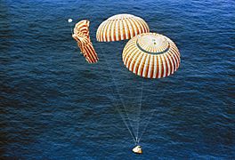
The Apollo 15 spacecraft splashed down safely despite a parachute failure. (NASA)
-
Apollo 15 splashdown (NASA)
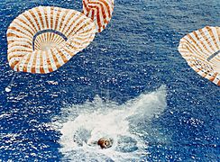
-
Apollo 11 after splashdown (NASA)
-
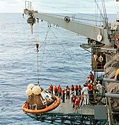
Apollo 13 hoisted onto ship (NASA)
-
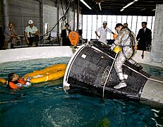
Gemini water egress training
-
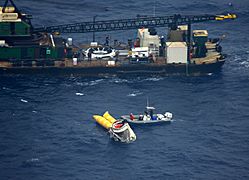
Recovery of the Dragon C2+ on May 31, 2012
-
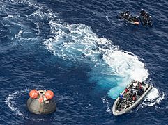
Recovery of the EFT-1 Orion, December 5, 2014
-
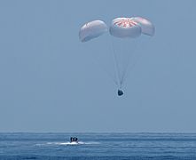
Landing of SpaceX Demo-2, 2 August 2020


.jpg)


.jpg)
See also
- Apollo program
- Apollo–Soyuz Test Project
- Helicopter 66
- Project Gemini
- Project Mercury
- Skylab
- SpaceX Dragon
- SpaceX Dragon 2
- Water landing
- Zond program
