
Spokane Valley, Washington facts for kids
Quick facts for kids
Spokane Valley, Washington
|
||
|---|---|---|
| City of Spokane Valley | ||

Spokane Valley City Hall
|
||
|
||
| Nickname(s):
The Valley
|
||
| Motto(s):
"A community of opportunity where individuals and families can grow and play, and businesses will flourish and prosper."
|
||
 |
||
| Country | United States | |
| State | Washington | |
| County | Spokane | |
| Settled | 1849 | |
| Incorporated | March 31, 2003 | |
| Named for | The Spokane Valley | |
| Government | ||
| • Type | Council–manager | |
| • Body | City council | |
| Area | ||
| • City | 38.01 sq mi (98.44 km2) | |
| • Land | 37.72 sq mi (97.69 km2) | |
| • Water | 0.29 sq mi (0.75 km2) | |
| Elevation | 2,002 ft (610 m) | |
| Population
(2010)
|
||
| • City | 89,755 | |
| • Estimate
(2019)
|
101,060 | |
| • Rank | US: 312th WA: 9th |
|
| • Density | 2,679.22/sq mi (1,034.46/km2) | |
| • Metro | 573,493 (US: 98th) | |
| • CSA | 721,396 (US: 72nd) | |
| Time zone | UTC−8 (Pacific (PST)) | |
| • Summer (DST) | UTC−7 (PDT) | |
| ZIP Code |
99206, 99216, 99212, 99016, 99027, 99037
|
|
| Area code(s) | 509 | |
| FIPS code | 53-67167 | |
| GNIS feature ID | 1967430 | |

Spokane Valley is a city in Spokane County, Washington, United States, and the largest suburb of Spokane. It is located east of Spokane, west of Coeur d'Alene, Idaho, and surrounds the city of Millwood on three sides. The city incorporated as the City of Spokane Valley on March 31, 2003. The Washington State Office of Financial Management estimates the city's population as 101,060 as of 2019. Spokane Valley is named after the valley of the Spokane River, in which it is located. The city and the general area is colloquially referred to as "The Valley" by residents of the Spokane–Coeur d'Alene area.
Spokane Valley hosts a variety of community events such as the Spokane County Interstate Fair, Valleyfest, and the Inland Northwest Craft Beer Festival and is home to the Spokane Valley Heritage Museum and the home ground of the Spokane Indians minor league baseball team.
Contents
History
For thousands of years, the Spokane Valley area was populated by members of the Upper Band of the Interior Salish Indians, calling themselves “Sn-tutuul-i”, the meaning of which is not known. In about 1783, fur traders from the North West Company began traveling through the area. They called these Indians the “Spokanes” which has been interpreted as meaning “Children of the Sun.” The Spokanes were a peaceful people, on friendly terms with neighboring tribes and later the fur traders and missionaries who came to the area. They fished salmon, hunted game, and ate camassia roots and berries they gathered.
Despite their many years of acceptance of the white settlers, and the calming influence of Chief Garry (sometimes Spokan Garry), the Spokanes protested the loss of their lands by joining in the Indian Rebellion of 1857. The final battle, in 1858, culminated in the Spokane Valley with the destruction of over 800 of their horses, their food, and teepees. The Spokanes were eventually forced from the lands of their ancestors to a reservation north of the Spokane River, just west of the Spokane area.
The first permanent white settler in the Spokane Valley was a retired French-Canadian trapper, Antoine Plante, who built a small cabin near the Spokane River in 1849. Plante ran a small Hudson's Bay Company trading post in the home he shared with his American Indian wife and family. In 1850, Plante constructed and operated the first ferry across the Spokane River, the only means of crossing the river in the area. It was used for transportation across the river by Fort Colville military personnel, U.S. Army surveyors, and miners traveling to western Montana and southeastern British Columbia.
In 1862, A. C. "Charley" Kendall established a store on the north side of the Spokane River. A bridge to cross the river at Kendall's store was soon built by Joe Herring, Timothy Lee, and Ned Jordan in 1864. A small community, known as Spokane Bridge, began to build up near the bridge. M. M. Cowley took over the holdings of Charley Kendall in 1872, including the bridge, a trading post and a log hotel.
Interestingly, the history of the settlement of the Spokane Valley predates the history of the city of Spokane, Washington. Spokane Valley holds many of the “firsts” for the Spokane area. In addition to being home to the area’s first settler, Antoine Plante, the Spokane Valley had the first business and first ferry in 1850; the first store (1862) and bridge (1864); the first house (1866); and the first post office (1867). All these firsts occurred before the 1873 arrival of James N. Glover, considered the founding father of Spokane.
Before the turn of the century, early pioneers, many of them silver miners, arrived from the East by way of the Northern Pacific and Great Northern railroads, for which Spokane was a major hub. By 1883, the first transcontinental rail was established. The railroad activity created support for extensive shops and facilities. Within a few years, Spokane was tied to the outside world by five transcontinental railroads, making it the hub of commerce it remains today.
Irrigation efforts stimulated population growth in the Spokane Valley significantly in the early part of the 20th century. Developers and real estate speculators tapped into nearby lakes, the Spokane River and the aquifer lying under the valley in an effort to turn the dry land into saleable agricultural land. In 1899, the Spokane Valley Land and Water Co., later owned by long-time irrigation advocate D.C. Corbin, built a canal to irrigate land in the Greenacres area with water from Liberty Lake. In 1905, the Spokane Canal Company built a canal to irrigate the Otis Orchard area with water from Newman Lake, and Modern Irrigation and Land Company tapped into the underground aquifer to irrigate 3,000 acres (12 km²) in Opportunity. Within just twenty years, 30,000 acres (120 km²) of dry land was converted into fertile farmland. Water access greatly increased land values. Valley population grew from 1,000 residents in 1900 to nearly 10,000 by 1922. Extensive apple orchards thrived in the gravelly soil of the Valley, and by 1912 nearly 2 million apple trees had been planted. A huge packing plant was built in 1911 by the Spokane Valley Growers Union.
With the exception of the incorporated Town of Millwood, Washington, the Spokane Valley was developed as townships with no governmental functions. Most of the townships platted in the early 1900s were surveyed as a tool for promotion and sales, and remain as names for neighborhoods and post office designations today.
A few Spokane Valley townships were developed for residential and/or business purposes. Trent was originally platted as a residential area for Northern Pacific railroad workers in 1881, Millwood began as a “company town”, developed by Inland Empire Paper Mill for their employees, and Dishman developed primarily as a business center. All other Valley townships were developed as irrigation districts and owe their existence to their agricultural roots. Between 1901 and 1915, the townships of Orchard Avenue, Greenacres, Otis Orchards, Opportunity, Vera, Dishman, Liberty Lake, Newman Lake, East Spokane, Mica and Chester were platted. Pasadena Park is a populated place located in Spokane County at latitude 47.697 and longitude -117.283, North of Millwood across the Spokane River that existed at least as early as 1916.
The Spokane Valley was promoted as a wonderful place to live. Though most Valley residents were farmers or orchardists, canneries, brickyards, railroad maintenance facilities and lumber mills provided jobs for many. The beauty of the surrounding area, pleasant communities, fertile farmlands, business opportunities, outdoor sports and activities, local recreational areas and community organizations caused it to be called “Spokane Valley, the Valley Bountiful”. As the population increased, small communities with schools, churches, businesses, community clubs and organizations thrived. Tied to Spokane, local lakes and Coeur d’Alene by railroads and bus systems, the people of the Valley enjoyed a full life.
In the years that followed, crop troubles and irrigation system maintenance problems prompted many residents to sell their farms in five, ten, or 20-acre (81,000 m2) plots for suburban home sites. Many of the apple trees were pulled out and replaced by neighborhoods and truck farms. The truck farms were successful in raising strawberries, raspberries, tomatoes, beans, peas, watermelons, asparagus, squash, cucumbers and thousands of acres of Heart of Gold cantaloupes. Dairy, poultry and fur farms also appeared in the Valley during these years.
While jobs were scarce during the Great Depression, most people in the Spokane Valley had enough land to grow food for their families. The Spokane Valley Chamber of Commerce adhered to a positive agenda throughout these hard times. They placed street signs on Valley roads and in an effort to show solidarity with Spokane, east-west roads were renamed to correspond with Spokane’s roads. Observing that fires were a constant and catastrophic problem for area residents, the Chamber lobbied to begin a fire protection district in the Valley. Their efforts were successful and Valley residents were first offered fire protection in 1940, with the formation of Spokane County Fire Protection District Number One.
The people of the valley always maintained independence from the City of Spokane on its borders. The first local newspaper, The Spokane Valley Herald, was launched in 1920. In 1919 an early municipal airfield was carved out, later named Felts Field in honor of Herald owner Buell Felts who died in a plane crash there. A streetcar line was started as early as 1908, and later extended to Liberty Lake in the east part of the valley, where entertainment facilities were built for music and outdoor gatherings. Other than Millwood, which incorporated in 1927 and Liberty Lake, Washington which did so in 2001, the Valley remained unincorporated throughout the 20th century.
Industry began to replace agriculture more rapidly after the completion of Grand Coulee Dam in 1941, which combined cheap electricity with readily available water from the Spokane River and the extensive aquifer which underlies the Valley. At its height, the Valley was the site for an aluminum plant, a cement plant and a paper mill. Plans to attract light industry through the establishment of an industrial park at a former military depot were not very successful. The cement plant closed in the 1950s, but the paper mill and aluminum plant remain.
In the 1950s a further transformation swept the valley as the post World War Two population boom began to push into the valley, replacing most of the remaining apple orchards with tracts of houses. The first shopping mall was built at University Village on Sprague Avenue (formerly called Appleway), which became the major artery through the Valley, lined with stores and restaurants. The last large-scale orchard irrigations ended in the late 1950s, canvas pipes running down residential streets replacing the old ditches by that time.
In the later decades of the last century the Valley experienced a large influx of retirees due to inexpensive housing and the relatively dry weather. Retirement complexes and apartment blocks began to appear. At the present time the Valley remains principally a suburban area, a mixture of families and retirees and the retail commerce to support them. In the 1990s and the early part of the twenty-first century the Spokane Valley continued to grow more urban, becoming one of the fastest growing regions in the state. Commercial growth increased and joined residential growth as it moved towards the state line. The urban development included the opening of the long-awaited Spokane Valley Mall in 1997, the establishment of dozens of other businesses along business corridors, and the development of the Mirabeau Point community complex.
The City of Spokane Valley incorporated on March 31, 2003, after being turned down in four previous referendums. At its creation, it was the third-largest newly incorporated city in US history (after Centennial, Colorado, which incorporated in 2001; and Miami Gardens, Florida, which incorporated about five weeks before Spokane Valley).
The situation of the City of Spokane Valley as an urban outgrowth of Spokane is very similar to the outgrowth of Sandy Springs, Georgia, a suburb of Atlanta. Sandy Springs would itself incorporate on December 1, 2005, passing City of Spokane Valley for third place on the list of largest newly incorporated U.S. cities.
Geography

Spokane Valley lies along both banks of the Spokane River as it flows between Idaho and the City of Spokane. Most of the city lies to the south of the river as the Selkirk Mountains rise immediately to the north of the river in most places. To the south of the valley rise Mica Peak and Krell Hill, the southernmost extremity of the Selkirks.
Spokane Valley city proper consists of the communities of Dishman, Greenacres, Opportunity, Trentwood, Veradale, Yardley, and parts of Chester and Otis Orchards. According to the United States Census Bureau, the city has a total area of 38.06 square miles (98.57 km2), of which, 37.77 square miles (97.82 km2) is land and 0.29 square miles (0.75 km2) is water.
Because the City of Spokane Valley shares its name with the unincorporated area it was carved from, the term "Spokane Valley" is often used in reference to an area greater than that which falls within the city limits.
Climate
Spokane Valley experiences a Mediterranean Climate (Köppen Csb), closely bordering on a dry-summer continental climate (Köppen Dsb).
| Climate data for Spokane (Felts Field) 1998-present normals and extremes | |||||||||||||
|---|---|---|---|---|---|---|---|---|---|---|---|---|---|
| Month | Jan | Feb | Mar | Apr | May | Jun | Jul | Aug | Sep | Oct | Nov | Dec | Year |
| Record high °F (°C) | 59 (15) |
60 (16) |
74 (23) |
87 (31) |
95 (35) |
108 (42) |
112 (44) |
112 (44) |
102 (39) |
86 (30) |
69 (21) |
63 (17) |
112 (44) |
| Mean maximum °F (°C) | 52 (11) |
54 (12) |
65 (18) |
77 (25) |
86 (30) |
93 (34) |
100 (38) |
99 (37) |
91 (33) |
76 (24) |
59 (15) |
52 (11) |
101 (38) |
| Average high °F (°C) | 37.1 (2.8) |
42.5 (5.8) |
51.0 (10.6) |
59.0 (15.0) |
68.6 (20.3) |
75.2 (24.0) |
87.0 (30.6) |
85.6 (29.8) |
75.6 (24.2) |
60.2 (15.7) |
44.8 (7.1) |
36.6 (2.6) |
60.3 (15.7) |
| Average low °F (°C) | 26.2 (−3.2) |
27.2 (−2.7) |
31.7 (−0.2) |
36.2 (2.3) |
43.3 (6.3) |
50.3 (10.2) |
56.2 (13.4) |
54.8 (12.7) |
46.6 (8.1) |
37.9 (3.3) |
30.6 (−0.8) |
25.6 (−3.6) |
38.9 (3.8) |
| Mean minimum °F (°C) | 10 (−12) |
15 (−9) |
20 (−7) |
27 (−3) |
32 (0) |
41 (5) |
46 (8) |
45 (7) |
36 (2) |
25 (−4) |
16 (−9) |
10 (−12) |
3 (−16) |
| Record low °F (°C) | −10 (−23) |
−3 (−19) |
2 (−17) |
24 (−4) |
28 (−2) |
37 (3) |
39 (4) |
40 (4) |
26 (−3) |
12 (−11) |
−2 (−19) |
−10 (−23) |
−10 (−23) |
| Average precipitation inches (mm) | 1.92 (49) |
1.14 (29) |
1.91 (49) |
1.23 (31) |
1.51 (38) |
1.66 (42) |
0.40 (10) |
0.51 (13) |
0.61 (15) |
1.10 (28) |
1.94 (49) |
2.31 (59) |
16.25 (413) |
Demographics
| Historical population | |||
|---|---|---|---|
| Census | Pop. | %± | |
| 2000 | 80,927 | — | |
| 2010 | 89,755 | 10.9% | |
| 2019 (est.) | 101,060 | 12.6% | |
| U.S. Decennial Census 2018 Estimate |
|||
2010 census
As of the census of 2010, there were 89,755 people, 36,558 households, and 23,119 families residing in the city. The population density was 2,376.4 inhabitants per square mile (917.5/km2). There were 38,851 housing units at an average density of 1,028.6 per square mile (397.1/km2). The racial makeup of the city was 90.9% White, 1.1% African American, 1.2% Native American, 1.7% Asian, 0.3% Pacific Islander, 1.4% from other races, and 3.3% from two or more races. Hispanic or Latino of any race were 4.6% of the population.
There were 36,558 households, of which 31.6% had children under the age of 18 living with them, 45.6% were married couples living together, 12.2% had a female householder with no husband present, 5.4% had a male householder with no wife present, and 36.8% were non-families. 29.0% of all households were made up of individuals, and 11.2% had someone living alone who was 65 years of age or older. The average household size was 2.43 and the average family size was 2.99.
The median age in the city was 37.3 years. 24% of residents were under the age of 18; 9.5% were between the ages of 18 and 24; 26.1% were from 25 to 44; 26.4% were from 45 to 64; and 14.1% were 65 years of age or older. The gender makeup of the city was 48.9% male and 51.1% female.
Arts and Culture
Museums
The Spokane Valley Heritage Museum opened its doors on August 18, 2005, and is located in the historic Opportunity Township Hall. The museum's goal is to collect, preserve and exhibit the history and culture of the Spokane Valley for the education and inspiration of the community. Visitors and researchers are welcome to search in the museum's vast archives of photos and documents, as well as view the current exhibits.
Sports

The Spokane Indians, a High Single-A baseball team in the Northwest League (NWL) and a farm team of the Colorado Rockies since 2021, have their home ground in the valley. The Indians play their home games at the 6,803-seat Avista Stadium and have won seven NWL titles since their Short-Season-A debut in 1982. Prior to 1982, the Indians played in the Triple-A level Pacific Coast League (PCL); the franchise has won 12 league titles: four in the PCL and eight in the NWL.
Spokane Valley hosts the annual Cycle Celebration, a cycling event presented by the organizers of Valleyfest. The event caters to beginning riders as well as more serious riders with 10-mile, 25-mile, and 50-mile marked routes with comfort stations along the course. Each route starts at the Mirabeau Point Park Meadows and the 10-mile course is routed east onto the Spokane River Centennial Trail, while the 25-mile course takes riders to the Saltese Uplands, and the most rigorous 50-mile course is routed through a rural area over hills and prairies that provide views of Mica Peak and Mount Spokane before reaching the finish line at Liberty Lake.
Education

Within Spokane Valley city limits, the public has access to one library which is part of the Spokane County Library District and features a studio which can be used for recording, production, and broadcasting. For educational attainment, 93.3 percent of the city residents have a high school diploma or higher and 23.4 percent hold a bachelor's degree or higher.
Public primary and secondary education in Spokane Valley is provided by multiple public school districts, including the Central Valley School District (CVSD), West Valley School District (WVSD), East Valley School District (EVSD), and a portion of western Spokane Valley by Spokane Public Schools (SPS). Of the school districts exclusive to the valley, the largest in terms of enrollment is CVSD with a student population of 14,593 in grades PK-12th grade, followed by EVSD with 4,277, and WVSD with 3,862. There are also several private schools in the city, most of which are parochial. Private schools include the PK-12 grade Valley Christian School, an ASCI-accredited non-denominational Christian school and The Oaks Academy, an ACCS-accredited K-12 non-denominational Christian school. High school students in the region can attend Spokane Valley Tech, a vocational school supported by a consortium of area school districts that offers free technical training for high school juniors and seniors to gain skills for career development in emerging industries and prepare for college. The Spokane Valley Tech Skills Center and STEM Academy primarily serves high school students attending public and private high schools in the greater Spokane area and eastern Washington region.
Historically, Spokane Valley had a four-year liberal arts college called Spokane University, which was founded in 1913 and was noted for its fine arts program which included Clyfford Still, a leading figure in the abstract expressionist movement as an alum; the university ceased operations in 1933 amidst the Great Depression. The locale it once occupied bears reminders of the institution in the form of a road name, University Road and a public high school that once used the former university campus, University High School. The Valley Christian School currently occupies the campus grounds.
Active higher education institutions in the Spokane Valley includes a campus of Carrington College, which primarily offers degree programs in healthcare fields such as medical assisting, veterinary assisting and medical billing and coding. The school has produced a large portion of the medical assistants in the area hospitals.
Infrastructure
Transportation

Roads and highways
Due to the city's suburban nature and its rural roots before its post World War II suburbanization, the design of Spokane Valley's streets contain many curvilinear streets, discontinuous streets, cul-de-sacs, and other features typical of suburbs. The major retail corridor and one of the most highly trafficked arterial roads in the city is Sprague Avenue, which travels east–west from downtown Spokane to Liberty Lake. Other east–west arterials for the valley include Trent Avenue, Mission Avenue, Broadway Avenue, and 32nd Avenue. Sprague Avenue in Spokane Valley is designated as Interstate 90 Business and Trent Avenue carries the designation of Washington State Route 290, where it is routed from the Interstate 90 Hamilton interchange in Spokane northeast to the Idaho border. For north–south travel, the major arterial streets are Argonne/Mullan roads, Pines road, Evergreen road and Sullivan road. Pines Road is the northernmost portion of Washington State Route 27, serving Spokane and Whitman counties and routed between Pullman and Spokane Valley where it terminates at the intersection with Trent Avenue; Washington State Route 27 is part of the Palouse Scenic Byway. Spokane Valley can be accessed from Interstate 90 at exits 285 to 293 as it travels from its termini of Seattle, Washington in the west to Boston, Massachusetts in the east, connecting Spokane, Spokane Valley, and Coeur d'Alene along its transcontinental route. The average commute to work is about 21 minutes. Traffic congestion on the interstate is increasing and causing travel delays particularly during peak commute hours according to the Washington State Department of Transportation (WSDOT); starting in 2019, the WSDOT started installing ramp meters to help reduce the congestion caused by accidents in particular, which contributed to a quarter of the congestion issues according to a study.
Public transportation
The public transportation needs for Spokane Valley as well as most of Spokane County is served by Spokane Transit Authority (STA), which maintains the Pence-Cole Valley Transit Center (VTC) and has a few park-and-ride locations throughout the city. The STA has one regular route, and two peak use express routes that service the VTC hub. Spokane Valley has a Walk Score of 25, indicating it is car-dependent and a Transit Score of 25 indicating there are some public transit options.
Airports
The closest major airport serving Spokane Valley and the Spokane–Coeur d'Alene area is Spokane International Airport, which is served by six airlines and is 16 miles (26 km) to the west in Spokane. Felts Field is a general aviation airport located near Spokane Valley along the south bank of the Spokane River; the Federal Aviation Administration categorizes it as a regional reliever facility.
Healthcare
Spokane Valley is served by one general hospital, the 123-bed MultiCare Valley Hospital as well as specialty and urgent care clinics operated by the MultiCare Health System, Providence Health & Services, and the Community Health Association of Spokane (CHAS Health), a non-profit Federally Qualified Health Center that primarily serves the needs of the uninsured with medical, dental, pharmacy, and behavioral health services. Ambulance service in Spokane County is contracted to American Medical Response (as of 2021).
Utilities
Electric service in Spokane Valley is provided by a variety of providers, including Avista Utilities, Inland Power & Light, Modern Electric Water Company, and Vera Water & Power. Water service is also provided by a patchwork of different providers, including the City of Spokane Water Department, Modern Electric Water Company, and various water districts. This is due to the rural beginnings of the neighborhoods that now make up the city of Spokane Valley and a legacy of the providers that came into operation to meet the needs of the agricultural consumers that predated the suburbanization of the area. The city draws its water supply from the Spokane Valley–Rathdrum Prairie Aquifer. For sewer service, Spokane County Environmental Services is the sole provider and Avista Utilities is the sole provider for natural gas. The valley is serviced by Xfinity Comcast and Centurylink and some smaller telecom providers for cable TV and residential internet.
Public safety
Fire department
The Spokane Valley Fire Department (SVFD) is a special-purpose fire district that has served the greater Spokane Valley area since 1940. The Department was originally formed as the Spokane Valley Fire Protection District No. 1, though they had unofficially been referred to as the "Spokane Valley Fire Department" or "Valley Fire Department" since the 1940s. SVFD officially adopted their present name in 2007. The SVFD provides emergency services to the cities of Spokane Valley, Liberty Lake, Millwood, and nearby areas of unincorporated Spokane County such as Otis Orchards and Pasadena Park.
Images for kids
-
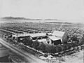
Orchard in Greenacres, c. 1903
-
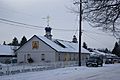
Holy Lady of Kazan Russian Orthodox Church
-
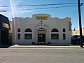
Spokane Valley Museum, housed in the old Opportunity Township Hall
-
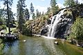
Mirabeau Point Park waterfall
.jpeg)


See also
 In Spanish: Spokane Valley (Washington) para niños
