
Spratly Islands facts for kids

The Spratly Islands are 100 small uninhabited islands in the South China Sea. A lot of fish are found around them so countries like China, Malaysia, Philippines, Taiwan, and Vietnam are interested in them. These countries share control of the islands but each of them want to take control of all or most of the islands.
Geographic and economic overview
The Spratly Islands were, in 1939, coral islets mostly inhabited by seabirds. Despite the Spratly Islands naturally consisting of 19 islands (see below), according to a Chinese 1986 source, the Spratly Islands consist of 14 islands or islets, 6 banks, 113 submerged reefs, 35 underwater banks and 21 underwater shoals.
The northeast part of the Spratlys is known as Dangerous Ground and is characterised by many low islands, sunken reefs, and degraded sunken atolls with coral often rising abruptly from ocean depths greater than 1,000 metres (3,300 ft) – all of which makes the area dangerous for navigation.
The islands are all of similar nature; they are cays (or keys): sand islands formed on old degraded and submerged coral reefs.
The Spratly Islands contain almost no significant arable land, have no indigenous inhabitants, and very few of the islands have a permanent drinkable water supply.
Natural resources include fish, guano, oil and natural gas. Economic activity has included commercial fishing, shipping, guano mining, oil and gas exploitation, and more recently, tourism. The Spratlys are located near several primary shipping lanes.
In 1987, China installed a small military structure on Fiery Cross Reef on the pretext to build an oceanic observation station and install a tide gauge for the Global Sea Level Observing System. After a deadly skirmish with the Vietnamese Navy, China installed some military structures on more reefs in the vicinity of the Philippines and Vietnamese occupied islands and this led to escalating tensions between these countries and China over the status and "ownership" of reefs.
The islands and cays, listed in descending order of naturally occurring area, are:
| # | Island name | in Atoll | Area (ha.) |
Location | Currently occupied by | Reclaimed area |
|---|---|---|---|---|---|---|
| 1 | Itu Aba Island | Tizard Bank | 46.00 | 10°23′N 114°21′E / 10.383°N 114.350°E | Taiwan (Taiping Island) | ~6ha |
| 2 | Thitu Island | Thitu Reefs | 37.20 | 11°03′N 114°17′E / 11.050°N 114.283°E | Philippines (Pagasa Island) | |
| 3 | West York Island | West York Island | 18.60 | 11°05′N 115°01′E / 11.083°N 115.017°E | Philippines (Likas Island) | |
| 4 | Spratly Island | Spratly Island | 13.00 | 08°38′N 111°55′E / 8.633°N 111.917°E | Vietnam (Trường Sa Island) | |
| 5 | Northeast Cay | North Danger Reef | 12.70 | 11°28′N 114°21′E / 11.467°N 114.350°E | Philippines (Parola Island) | |
| 6 | Southwest Cay | North Danger Reef | 12.00 | 11°26′N 114°20′E / 11.433°N 114.333°E | Vietnam (Song Tử Tây Island) | ~8ha |
| 7 | Sin Cowe Island | Union Banks | 08.00 | 09°52′N 114°19′E / 9.867°N 114.317°E | Vietnam (Sinh Tồn Island) | ~1ha |
| 8 | Nanshan Island | Nanshan Group | 07.93 | 10°45′N 115°49′E / 10.750°N 115.817°E | Philippines (Lawak Island) | |
| 9 | Sand Cay | Tizard Bank | 07.00 | 10°23′N 114°28′E / 10.383°N 114.467°E | Vietnam (Son Ca Island) | ~2.1ha |
| 10 | Loaita Island | Loaita Bank | 06.45 | 10°40′N 114°25′E / 10.667°N 114.417°E | Philippines (Kota Island) | |
| 11 | Swallow Reef | Swallow Reef | 06.20 | 07°22′N 113°50′E / 7.367°N 113.833°E | Malaysia (Layang-Layang Reef) | |
| 12 | Namyit Island | Tizard Bank | 05.30 | 10°11′N 114°22′E / 10.183°N 114.367°E | Vietnam (Nam Yet Island) | |
| 13 | Amboyna Cay | Amboyna Cay | 01.60 | 07°51′N 112°55′E / 7.850°N 112.917°E | Vietnam (An Bang Island) | |
| 14 | Grierson Reef | Union Banks | 01.60 | 09°51′N 114°29′E / 9.850°N 114.483°E | Vietnam | |
| 15 | West London Reef | London Reefs | 01.10 | Vietnam | ||
| 16 | Central London Reef | London Reefs | 00.88 | Vietnam | ||
| 17 | Flat Island | Nanshan Group | 00.57 | 10°49′N 115°49′E / 10.817°N 115.817°E | Philippines (Patag Island) | |
| 18 | Lankiam Cay | Loaita Bank | 00.44 | 10°43′N 114°32′E / 10.717°N 114.533°E | Philippines (Panata Island) |
The total area of the archipelago's naturally occurring islands is 177 ha (440 acres) and 200 ha (490 acres) with reclaimed land.
Images for kids
-
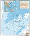
The Spratly Islands
-
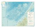
A geographic map of Spratly Islands
-
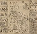
The Velarde map shows actual Philippine control over Scarborough Shoal, as well as islands off of Palawan, identified as the Spratly Islands. The map was one of the key evidences in the Philippines v. China international case that debunked China's so-called nine-dash line claims.
-
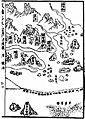
Mao Kun map, Spratly Islands is suggested to be the islands at the bottom right (Chinese: 石星石塘; pinyin: shíxīng shítáng). Others however believe the islands may refer to the Paracel Islands or Macclesfield Bank.
-
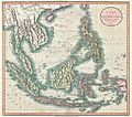
An 1801 Cary Map of the East Indies and Southeast Asia, with isles similar to those in the Mao Kun map. The isles are not the Paracels or Spratly Islands, but are instead identified as "Pulo Taya" and "Amphitrite".
-
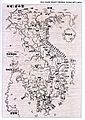
An 1838 Unified Dai Nam map marking Trường Sa and Hoàng Sa, which are considered as Spratly and Paracel Islands by some Vietnamese scholars; yet they share different latitude, location, shape and distance. The Paracel claim may have been correctly identified, however, the "Spratly" claim on the map may instead be islands nearer to Vietnamese shores, instead of the actual Spratly Islands.
-
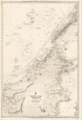
A striking large black and white British chart of the sea in northern Borneo, first issued in 1881 and corrected to 1935.
-
China's (now ROC and PRC) nine-dash line claim over the South China Sea, 1947
-
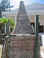
Territorial monument of the Republic of Vietnam (South Vietnam) on Southwest Cay, Spratly Islands, defining the cay as part of Vietnamese territory (Phước Tuy Province). Used from 22 August 1956 until 1975, when replaced by another one from the Socialist Republic of Vietnam (successor state after the Fall of Saigon)
-
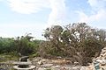
An ancient Heliotropium foertherianum on Spratly Island
-
Young Vietnamese residents of Spratly Island
-
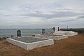
A military cemetery for Vietnamese soldiers on Central London Reef
-
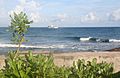
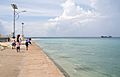
A view from Amboyna Cay
-
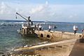
The Pearson Reef dock under Vietnam's administration
.jpg)


_-_Geographicus_-_EastIndies-cary-1801.jpg)


See also
 In Spanish: Islas Spratly para niños
