Spring Hill, Tennessee facts for kids
Quick facts for kids
Spring Hill, Tennessee
|
||
|---|---|---|
| City of Spring Hill | ||

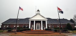
Spring Hill City Hall, December 2013.
|
||
|
||
| Motto(s):
"A blend of Commerce, History and Country Living"
|
||

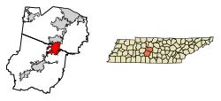
Location of Spring Hill in Williamson & Maury County Tennessee.
|
||
| Country | United States | |
| State | Tennessee | |
| Counties | Williamson, Maury | |
| City | 1808 | |
| Government | ||
| • Type | City | |
| Area | ||
| • Total | 26.83 sq mi (69.50 km2) | |
| • Land | 26.79 sq mi (69.38 km2) | |
| • Water | 0.05 sq mi (0.12 km2) | |
| Elevation | 751 ft (229 m) | |
| Population
(2020)
|
||
| • Total | 50,005 |
|
| • Density | 1,634.03/sq mi (630.89/km2) | |
| Time zone | UTC-6 (Central (CST)) | |
| • Summer (DST) | UTC-5 (CDT) | |
| ZIP code |
37174 also includes portion of 37179
|
|
| Area code(s) | 931 615 | |
| FIPS code | 47-70580 | |
| GNIS feature ID | 1303764 | |
Spring Hill is a city in Maury and Williamson counties, Tennessee, located approximately 30 miles (48 km) south of Nashville. Spring Hill's population as of 2020 was 50,005. Spring Hill is recognized as the 4th fastest growing city in Tennessee by the U.S. Census Bureau and is included in the Nashville metropolitan area.
Contents
History
The first settlers of Spring Hill arrived in 1808 and the city was established in 1809. Albert Russell was the first person to build a home on the land that became Spring Hill.
Spring Hill was the site of a Civil War battle, now known as the Battle of Spring Hill, on November 29, 1864.
Later, Spring Hill was the home of a preparatory school, Branham and Hughes Military Academy, the campus of which now serves as the main campus of Tennessee Children's Home, a ministry associated with the Churches of Christ.
Geography
Spring Hill is located at 35°45′9″N 86°54′50″W / 35.75250°N 86.91389°W (35.752556, -86.914021).
According to the United States Census Bureau, the city has a total area of 17.7 square miles (45.9 km²), of which 17.7 square miles (45.9 km²) is land and 0.04 square mile (0.1 km²) (0.17%) is water.
The official main street of Spring Hill is also called US Highway 31, Columbia Pike or Nashville Highway.
Demographics
| Historical population | |||
|---|---|---|---|
| Census | Pop. | %± | |
| 1880 | 400 | — | |
| 1910 | 695 | — | |
| 1920 | 403 | −42.0% | |
| 1930 | 416 | 3.2% | |
| 1940 | 543 | 30.5% | |
| 1950 | 541 | −0.4% | |
| 1960 | 689 | 27.4% | |
| 1970 | 685 | −0.6% | |
| 1980 | 989 | 44.4% | |
| 1990 | 1,464 | 48.0% | |
| 2000 | 7,715 | 427.0% | |
| 2010 | 29,036 | 276.4% | |
| 2020 | 50,005 | 72.2% | |
| Sources: | |||
2020 census
| Race | Number | Percentage |
|---|---|---|
| White (non-Hispanic) | 39,622 | 79.24% |
| Black or African American (non-Hispanic) | 2,929 | 5.86% |
| Native American | 94 | 0.19% |
| Asian | 1,082 | 2.16% |
| Pacific Islander | 35 | 0.07% |
| Other/Mixed | 2,310 | 4.62% |
| Hispanic or Latino | 3,933 | 7.87% |
As of the 2020 United States census, there were 50,005 people, 12,727 households, and 10,582 families residing in the city.
2010 census
As of the 2010 United States Census, there were 29,036 people, 9,861 households, and 7,884 families living in the city. The population density was 1,640.45 persons per square mile and the housing unit density was 557.12 units per square mile. The racial makeup of the city was 89.14% White, 5.39% Black or African American, 1.64% Asian, 0.24% Native American, 0.17% Pacific Islander, 1.53% from other races, and 1.90% from two or more races. Those of Hispanic or Latino origins were 5.65% of the population.
Of the 9,861 households, 50.34% had children under the age of 18 living in them, 67.26% were married couples living together, 2.80% had a male householder with no wife present, 9.89% had a female householder with no husband present, and 20.05% were non-families. 16.49% of all households were made up of individuals, and 3.26% had someone living alone who was 65 years of age or older. The average household size was 2.94 and the average family size was 3.33.
Of the 29,036 residents, 33.89% were under the age of 18, 61.08% were between the ages of 18 and 64, and 5.02% were 65 years of age or older. The median age was 31.9 years. 51.46% of the residents were female, and 48.54% were male.
The median household income in the city was $72,744 and the median family income was $78,125. Males had a median income of $54,905 versus $42,216 for females. The per capita income for the city was $27,709. About 2.8% of families and 3.6% of the population were below the poverty line, including 4.4% of those under the age of 18 and 2.9% of those age 65 and over.
Arts and culture
Attractions
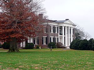
Rippavilla Plantation, which is located at 5700 Main Street (TN-31, Columbia Pike, or Nashville Hwy), offers educational activities and an annual corn maze among other attractions.
Economy
Spring Hill was the site of the Saturn Corporation production facility, which operated from 1990 to 2007. The Saturn S-Series, Saturn ION, and Saturn VUE were produced there. In 2007, General Motors Corporation (GM), the parent company of Saturn, shut down the facility to retool it for production of other GM vehicles and renamed it Spring Hill Manufacturing. The plant reopened in February 2008 and became the assembly point for the new Chevrolet Traverse. However, after a battle among plants in Spring Hill, Orion Township, Michigan and Janesville, Wisconsin, GM announced on June 26, 2009 that they had chosen to build a new small car in Orion Township. Nearly 2,500 Spring Hill auto workers were faced with lay-off, buy-out and early retirement. The vehicle assembly part of the Spring Hill plant was idled in late 2009 when production of the Traverse was moved to Lansing, Michigan, while production of power trains and metal stamping continued. In November 2011, GM announced plans for retooling of the vehicle assembly portion of the plant for use as an "ultra-flexible" plant which will initially be used to build the Chevy Equinox and GMC Terrain but will be designed for rapid retooling to other vehicles of similar size. In April of 2021 General Motors and South Korean joint-venture partner LG Energy Solution said they will build a second U.S. battery cell manufacturing plant, revealing plans for a $2.3 billion factory in Spring Hill, Tennessee.
Spring Hill has gone through rapid development and growth in recent years, causing General Motors to reopen their auto plant and begin hiring locally again, which will hire 1,000 new people. In addition, companies such as Ryder and Goodwill have announced new facilities in the Spring Hill area.
Education
The city is served by both Maury County Public Schools and the Williamson County School District.
Schools in Maury County
- Columbia Academy (Private)
- Battle Creek Elementary School (Public)
- Battle Creek Middle School (Public)
- Marvin Wright Elementary School (Public)
- Spring Hill Elementary School (Public)
- Spring Hill High School (Public)
- Spring Hill Middle School (Public)
- Zion Christian Academy (Private)
Schools in Williamson County
- Allendale Elementary (Public)
- Bethesda Elementary (Public)
- Chapmans Retreat Elementary (Public)
- Heritage Elementary (Public)
- Heritage Middle (Public)
- Longview Elementary (Public)
- Spring Hill Academy (Private)
- Spring Station Middle (Public)
- Summit High (Public)
Infrastructure
Interstate 65 passes through the eastern part of the city, but the only exit currently within city limits is State Route 396. An interchange on the north side of the city at an extended Buckner Road is scheduled to open in 2024. State Route 396, known locally as Saturn Parkway, provides an east-west freeway connection into the city with two exits before terminating at Beechcroft Road near the GM plant. U.S. Route 31 is the main north-south arterial through Spring Hill. It is alternatively called both Columbia Pike on the north side of town and Nashville Highway on the south side. State Route 247 is a major east-west road through the city.
See also
 In Spanish: Spring Hill (Tennessee) para niños


