
St. Clair County, Illinois facts for kids
Quick facts for kids
St. Clair County
|
||
|---|---|---|

St. Clair County Courthouse in Belleville
|
||
|
||

Location within the U.S. state of Illinois
|
||
 Illinois's location within the U.S. |
||
| Country | ||
| State | ||
| Founded | 1790 | |
| Named for | Arthur St. Clair | |
| Seat | Belleville | |
| Largest city | Belleville | |
| Area | ||
| • Total | 674 sq mi (1,750 km2) | |
| • Land | 658 sq mi (1,700 km2) | |
| • Water | 16 sq mi (40 km2) 2.4% | |
| Population
(2020)
|
||
| • Total | 257,400 | |
| • Density | 381.9/sq mi (147.45/km2) | |
| Time zone | UTC−6 (Central) | |
| • Summer (DST) | UTC−5 (CDT) | |
| Congressional district | 12th | |


St. Clair County is the oldest county in Illinois; its western border is formed by the Mississippi River, bordering Missouri. It is a part of the Metro East in southern Illinois. According to the 2020 United States Census, it had a population of 257,400, making it the eighth-most populous county in Illinois and the most populous in the southern portion of the state. Its county seat is Belleville. The county was founded in 1790 by the government of the Northwest Territory, from the western half of Knox County, before the establishment of Illinois as a state as the base for the Illinois Territory. Cahokia Village in the county was founded in 1697 and was a French settlement and former Jesuit mission.
St. Clair County is part of the American Bottom or Metro-East area of the St. Louis, MO-IL Metropolitan Statistical Area.
In 1970, the United States Census Bureau placed the mean center of U.S. population in St. Clair County.
Contents
Demographics
| Historical population | |||
|---|---|---|---|
| Census | Pop. | %± | |
| 1820 | 5,253 | — | |
| 1830 | 7,078 | 34.7% | |
| 1840 | 13,631 | 92.6% | |
| 1850 | 20,180 | 48.0% | |
| 1860 | 37,694 | 86.8% | |
| 1870 | 51,068 | 35.5% | |
| 1880 | 61,806 | 21.0% | |
| 1890 | 66,571 | 7.7% | |
| 1900 | 86,685 | 30.2% | |
| 1910 | 119,870 | 38.3% | |
| 1920 | 136,520 | 13.9% | |
| 1930 | 157,775 | 15.6% | |
| 1940 | 166,899 | 5.8% | |
| 1950 | 205,995 | 23.4% | |
| 1960 | 262,509 | 27.4% | |
| 1970 | 285,176 | 8.6% | |
| 1980 | 267,531 | −6.2% | |
| 1990 | 262,852 | −1.7% | |
| 2000 | 256,082 | −2.6% | |
| 2010 | 270,056 | 5.5% | |
| 2020 | 257,400 | −4.7% | |
| US Decennial Census 1790-1960 1900-1990 1990-2000 2010-2019 |
|||
In the 2020 United States Census the racial makeup of the county was 59.6% White, 29.7% black or African American, 1.4% Asian, 0.3% American Indian, 0.1% Pacific islander, 2.1% from other races, and 6.8% from two or more races. 4.9% were of Hispanic or Latino origin.
As of the 2010 United States Census, there were 270,056 people, 105,045 households, and 70,689 families residing in the county. The population density was 410.6 inhabitants per square mile (158.5/km2). There were 116,249 housing units at an average density of 176.7 per square mile (68.2/km2). The racial makeup of the county was 64.6% white, 30.5% black or African American, 1.2% Asian, 0.2% American Indian, 0.1% Pacific islander, 1.2% from other races, and 2.2% from two or more races. Those of Hispanic or Latino origin made up 3.3% of the population. In terms of ancestry, 27.5% were German, 11.1% were Irish, 7.4% were English, and 4.6% were American.
Of the 105,045 households, 34.7% had children under the age of 18 living with them, 44.6% were married couples living together, 17.7% had a female householder with no husband present, 32.7% were non-families, and 27.5% of all households were made up of individuals. The average household size was 2.53 and the average family size was 3.09. The median age was 36.9 years.
The median income for a household in the county was $48,562 and the median income for a family was $61,042. Males had a median income of $47,958 versus $34,774 for females. The per capita income for the county was $24,770. About 12.3% of families and 15.5% of the population were below the poverty line, including 24.7% of those under age 18 and 9.7% of those age 65 or over.
Transportation
Major highways
 Interstate 55
 Interstate 64
 Interstate 70
 Interstate 255
 U.S. Highway 40
 U.S. Highway 50
 Illinois Route 3
 Illinois Route 4
 Illinois Route 13
 Illinois Route 15
 Illinois Route 111
 Illinois Route 156
 Illinois Route 157
 Illinois Route 158
 Illinois Route 159
 Illinois Route 161
 Illinois Route 163
 Illinois Route 177
 Illinois Route 203
Public transit
St. Clair County is home to 11 St. Louis MetroLink stations on the Red and Blue Lines.
- East Riverfront
- 5th & Missouri
- Emerson Park
- Jackie Joyner-Kersee Center
- Washington Park
- Fairview Heights
- Memorial Hospital
- Swansea
- Belleville
- College
- Shiloh-Scott
St. Clair County is also served by Metrobus and Madison County Transit.
Adjacent counties and city
- Madison County (north)
- Clinton County (northeast)
- Washington County (east)
- Randolph County (south)
- Monroe County (southwest)
- St. Louis, Missouri (west)
- St. Louis County, Missouri (west)
Images for kids
-
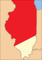
St. Clair County as it was re-established in 1809. This diagonal border line had been drawn by the Indiana Territorial government in 1803.
-
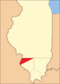
St. Clair County between 1812 and 1813
-
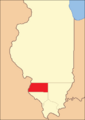
St. Clair County between 1813 and 1816
-
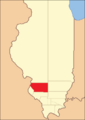
St. Clair County between 1816 and 1818
-
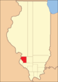
St. Clair County between 1818 and 1825
-
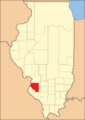
St. Clair County between 1825 and 1827
-
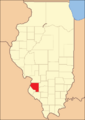
St. Clair County from 1827 to present


See also
 In Spanish: Condado de St. Clair (Illinois) para niños
