St. Joseph County, Michigan facts for kids
Quick facts for kids
Saint Joseph County
|
||
|---|---|---|

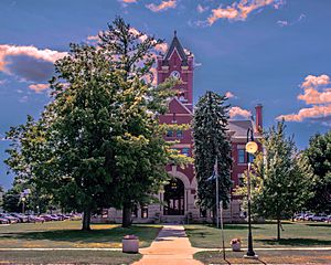
St. Joseph County Courthouse in Centreville
|
||
|
||

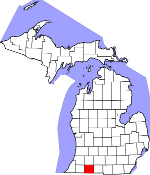
Location within the U.S. state of Michigan
|
||
 Michigan's location within the U.S. |
||
| Country | ||
| State | ||
| Founded | 1829 | |
| Named for | Fort St. Joseph | |
| Seat | Centreville | |
| Largest city | Sturgis | |
| Area | ||
| • Total | 521 sq mi (1,350 km2) | |
| • Land | 501 sq mi (1,300 km2) | |
| • Water | 20 sq mi (50 km2) 3.9%% | |
| Population
(2020)
|
||
| • Total | 60,939 | |
| • Density | 122/sq mi (47/km2) | |
| Time zone | UTC−5 (Eastern) | |
| • Summer (DST) | UTC−4 (EDT) | |
| Congressional district | 6th | |
St. Joseph County is a county located in the U.S. state of Michigan, on the central southern border with Indiana. As of the 2020 United States Census, the population was 60,939. The county seat is Centreville.
French colonists in the late 17th century were the first Europeans to explore this territory, and they named the St. Joseph River for the patron saint of New France. This area was not part of the United States until after the American Revolutionary War. After the Treaty of Chicago was signed in 1821, regional tribes of the indigenous peoples ceded much land to the United States, opening the area for American settlement. The county was set off and organized by the Michigan Territory legislature in 1829; it was named for the river.
St. Joseph County comprises the Sturgis, MI Micropolitan Statistical Area and is included in the Kalamazoo-Battle Creek-Portage, MI Combined Statistical Area.
Demographics
| Historical population | |||
|---|---|---|---|
| Census | Pop. | %± | |
| 1830 | 1,313 | — | |
| 1840 | 7,068 | 438.3% | |
| 1850 | 12,725 | 80.0% | |
| 1860 | 21,262 | 67.1% | |
| 1870 | 26,275 | 23.6% | |
| 1880 | 26,626 | 1.3% | |
| 1890 | 23,356 | −12.3% | |
| 1900 | 23,889 | 2.3% | |
| 1910 | 25,499 | 6.7% | |
| 1920 | 26,818 | 5.2% | |
| 1930 | 30,618 | 14.2% | |
| 1940 | 31,749 | 3.7% | |
| 1950 | 35,071 | 10.5% | |
| 1960 | 42,332 | 20.7% | |
| 1970 | 47,392 | 12.0% | |
| 1980 | 56,083 | 18.3% | |
| 1990 | 58,913 | 5.0% | |
| 2000 | 62,422 | 6.0% | |
| 2010 | 61,295 | −1.8% | |
| 2020 | 60,939 | −0.6% | |
| US Decennial Census 1790-1960 1900-1990 1990-2000 2010-2018 |
|||
The 2010 census indicates St. Joseph County had a 2010 population of 61,295. This decrease of -1,127 people from the 2000 United States Census represents a -1.8% population change (decrease) in that decade. In 2010 there were 23,244 households and 16,275 families in the county. The population density was 122.4 per square mile (47.3 square kilometers). There were 27,778 housing units at an average density of 55.5 per square mile (21.4 per km2). The racial and ethnic makeup of the county was 88.0% White, 2.5% Black or African American, 0.4% Native American, 0.7% Asian, 6.6% Hispanic or Latino, 0.1% from other races, and 1.8% from two or more races.
There were 23,244 households, out of which 33.0% had children under the age of 18 living with them, 52.6% were husband and wife families, 11.7% had a female householder with no husband present, 30.0% were non-families, and 24.8% were made up of individuals. The average household size was 2.60 and the average family size was 3.08.
The county population contained 25.9% under age of 18, 8.1% from 18 to 24, 23.8% from 25 to 44, 27.4% from 45 to 64, and 14.9% who were 65 years of age or older. The median age was 39 years. For every 100 females there were 97.9 males. For every 100 females age 18 and over, there were 95.9 males.
The 2010 American Community Survey 3-year estimate indicates the median income for a household in the county was $43,964 and the median income for a family was $52,600. Males had a median income of $30,517 versus $16,388 for females. The per capita income for the county was $19,737. About 1.8% of families and 16.3% of the population were below the poverty line, including 22.3% of those under the age 18 and 12.3% of those age 65 or over.
Images for kids
See also
 In Spanish: Condado de St. Joseph (Míchigan) para niños


