
St Lawrence, Queensland facts for kids
Quick facts for kids St LawrenceQueensland |
|||||||||||||||
|---|---|---|---|---|---|---|---|---|---|---|---|---|---|---|---|

View along St Lawrence's main street
|
|||||||||||||||

St Lawrence
Location in Queensland
|
|||||||||||||||
| Population | 235 (2016 census) | ||||||||||||||
| • Density | 0.1701/km2 (0.441/sq mi) | ||||||||||||||
| Postcode(s) | 4707 | ||||||||||||||
| Elevation | 18 m (59 ft) | ||||||||||||||
| Area | 1,381.8 km2 (533.5 sq mi) | ||||||||||||||
| Time zone | AEST (UTC+10:00) | ||||||||||||||
| Location |
|
||||||||||||||
| LGA(s) | Isaac Region | ||||||||||||||
| State electorate(s) | Mirani | ||||||||||||||
| Federal Division(s) | Capricornia | ||||||||||||||
|
|||||||||||||||
|
|||||||||||||||
St Lawrence is a rural town and locality in the Isaac Region, Queensland, Australia. In the 2016 census the locality of St Lawrence had a population of 235 people.
Geography
St Lawrence is located 802 kilometres (498 mi) north of Brisbane and 6 kilometres (3.7 mi) off the Bruce Highway.The town is located south of St Lawrence Creek, which flows into a vast bay known as Broad Sound, a waterway noted for its large tidal range (up to 9 metres (30 ft) in the summer).
The North Coast railway line passes through the town, which is served by St Lawrence railway station.
History

The township of St Lawrence was originally established to maintain the Customs Office for the Port of St Lawrence.
The St Lawrence State School opened on 28 May 1871.
At the 2006 census, St Lawrence and the surrounding area had a population of 195.
St Lawrence was the administrative centre of the Shire of Broadsound until 2008, when the shire was amalgamated with the Shire of Belyando and the Shire of Nebo to form the Isaac Region local government area. Moranbah is the administrative centre of the new region but the former Broadsound Shire offices at 36 Macartney Street are still used as the local offices of the Isaac Regional Council. The building was described in 2004 as "a disarmingly elegant building which seems quite out of place in this otherwise undistinguished town".
Once a prosperous port town, exporting cattle from the hinterland, most residents are now railway workers.
Heritage listings
St Lawrence has a number of heritage-listed sites, including:
- Cannon Street: Christ Church Anglican Church
- Macartney Street: St Lawrence Police Station
- Settlement Road: Meatworks and Wharf Site
Gallery
-
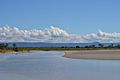
St Lawrence River - low tide
-
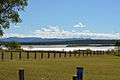
St Lawrence River - across the park
-
St Lawrence - Bird watching


Education
St Lawrence State School is a government primary (Prep-6) school for boys and girls at Macartney Street (22°20′42″S 149°31′47″E / 22.3449°S 149.5297°E). In 2015, it had an enrolment of 10 students with 2 teachers (1 equivalent full-time). In 2018, the school had an enrolment of 9 students with 2 teachers (1 full-time equivalent) and 6 non-teaching staff (2 full-time equivalent). The school motto is 'Knowledge, Truth, Honesty'.
The original school was opened on 28 May 1871 but it was completely destroyed by a cyclone on 22 January 1874 and had to be rebuilt. A new school building was officially opened on 17 June 1938. The school was completely destroyed by fire on 30 October 2007. A mobile classroom was transported from Brisbane as the school's permanent replacement. A wishing well handcrafted by Jack Dempsey was installed at the site and dedicated in 2008 in remembrance of the previous school building.
St Lawrence State School celebrated its 150th anniversary in 2021.
There is no secondary school in St Lawrence nor nearby. Distance education and boarding school are options.
Images for kids
-
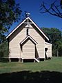
Christ Church Anglican, 2009

