
Stafford County, Virginia facts for kids
Quick facts for kids
Stafford County
|
|
|---|---|

Stafford County Courthouse
|
|

Location within the U.S. state of Virginia
|
|
 Virginia's location within the U.S. |
|
| Country | |
| State | |
| Founded | 1664 |
| Named for | Staffordshire, England |
| Seat | Stafford |
| Largest community | Aquia Harbor |
| Area | |
| • Total | 280 sq mi (700 km2) |
| • Land | 269 sq mi (700 km2) |
| • Water | 11 sq mi (30 km2) 3.9% |
| Population
(2020)
|
|
| • Total | 156,927 |
| • Density | 560/sq mi (216/km2) |
| Time zone | UTC−5 (Eastern) |
| • Summer (DST) | UTC−4 (EDT) |
| Congressional district | 1st |
Stafford County is located in the Commonwealth of Virginia. It is a suburb outside of Washington D.C. It is approximately 40 miles (64 km) south of D.C. It is part of the Northern Virginia region, and the D.C area. It is one of the fastest growing, and highest-income counties in America. As of the 2020 census, the population sits at 156,927. Its county seat is Stafford.
Located across the Rappahannock River from the City of Fredericksburg, Stafford County is part of the Washington-Arlington-Alexandria, DC-VA-MD-WV Metropolitan Statistical Area. In 2006, and again in 2009, Stafford was ranked by Forbes magazine as the 11th highest-income county in the United States. According to a Census Bureau report released in 2019, Stafford County is currently the sixth highest-income county in America.
Contents
History
For thousands of years, various cultures of indigenous peoples succeeded each other in their territories along the Potomac River and its tributaries. By the time of English colonization, there were 32 Algonquian-speaking American Indian tribes in the present-day coastal Tidewater Virginia area, including those of the Patawomeck and numerous tribes that were part of the Powhatan Confederacy. The former small tribe, still centered in Stafford County, was recognized by the state of Virginia in 2010.
The Native Americans' first recorded encounter with Europeans in this area was in 1608, with John Smith of the Jamestown Settlement. During a time of recurring tension between the early English colonists and local Native Americans, the colonists led by Samuel Argall captured Chief Powhatan's daughter, Pocahontas while she was residing with her husband, Kocoum. It occurred in the eastern part of this county, from where they took her to a secondary English settlement, known as Henricus (or Henrico Town). Alexander Whitaker converted Pocahontas to Christianity during her captivity. He renamed the princess "Rebecca" at her baptism. Rebecca married English colonist John Rolfe on April 5, 1614 in Jamestown.
The English colonial government of Virginia imposed its own order on the land and peoples. In 1664 it established Stafford County from territory previously part of Westmoreland County (which itself had been created from Northumberland County in 1653). It was named after Staffordshire, England. As originally delineated, Stafford County included a much larger area than its current borders, and in fact encompassed what would later become Arlington, Fairfax, and Prince William, and the City of Alexandria. It is part of the area now considered Northern Virginia. George Washington spent much of his childhood in the lower part of the county on his family's home, Ferry Farm, along the Rappahannock River across from Fredericksburg. Colonial Forge High School was built on a tract of land owned in colonial times by his father Augustine Washington. George Mason, another Founding Father of the nation, also spent his formative years in Stafford.
Aquia Church, built in 1757, is unusual among local structures for having been designed on the plan of a Greek cross rather than the more standard Roman Cross design. In addition, Aquia Church has a rare three-tiered pulpit; it has been designated a National Historic Landmark. The Episcopal church continues to be active today.
Stafford County industry and resources were important to the colony and early nation. During the Revolutionary War, the Stafford ironworks furnished arms for the colonial rebel soldiers. Aquia Creek sandstone, quarried from Government Island, was used to build the White House and the U.S. Capitol.
During the American Civil War, the county was part of the battlegrounds, occupied by more than 100,000 troops for several years. The Battle of Aquia Creek took place in the Aquia Harbour area. Both the Union Army and Confederate Army struggled to control the strategic Potomac Creek Bridge at various times during the war.
Falmouth, a town bordering Fredericksburg, was the home of late-19th century artist Gari Melchers, whose house, Belmont, still stands.
Stafford County today is considered part of the Washington, D.C. metropolitan area. Many residents commute to work in Washington and its environs north on Interstate Highway 95, U.S. Route 1, and Virginia Railway Express.
In the early morning hours of May 9, 2008, a tornado touched down in the southern part of the county, severely damaging about 140 suburban homes.
The county was also severely affected by "Snowmageddon," the massive blizzards of December 2009 and February 2010. Stafford received some of the heaviest snow in the D.C. metropolitan area, with about 25 inches of snow in December, and 19 inches in February.
Geography
According to the U.S. Census Bureau, the county has a total area of 280 square miles (730 km2), of which 269 square miles (700 km2) is land and 11 square miles (28 km2) (3.9%) is water. The Potomac River flows along part of the eastern border of the county, while the Rappahannock River runs along the extent of the county's southern border. Aquia Creek empties into the tidal segment of the Potomac River at Brent Point in Stafford County.
Major bodies of water
Adjacent counties and independent city
|
|
Demographics
| Historical population | |||
|---|---|---|---|
| Census | Pop. | %± | |
| 1790 | 9,588 | — | |
| 1800 | 9,971 | 4.0% | |
| 1810 | 9,830 | −1.4% | |
| 1820 | 9,517 | −3.2% | |
| 1830 | 9,362 | −1.6% | |
| 1840 | 8,454 | −9.7% | |
| 1850 | 8,044 | −4.8% | |
| 1860 | 8,555 | 6.4% | |
| 1870 | 6,420 | −25.0% | |
| 1880 | 7,211 | 12.3% | |
| 1890 | 7,362 | 2.1% | |
| 1900 | 8,097 | 10.0% | |
| 1910 | 8,070 | −0.3% | |
| 1920 | 8,104 | 0.4% | |
| 1930 | 8,050 | −0.7% | |
| 1940 | 9,548 | 18.6% | |
| 1950 | 11,902 | 24.7% | |
| 1960 | 16,876 | 41.8% | |
| 1970 | 24,587 | 45.7% | |
| 1980 | 40,470 | 64.6% | |
| 1990 | 61,236 | 51.3% | |
| 2000 | 92,446 | 51.0% | |
| 2010 | 128,961 | 39.5% | |
| 2020 | 156,927 | 21.7% | |
| U.S. Decennial Census 1790–1960 1900–1990 1990–2000 2010 2020 |
|||
2020 Census
| Race / Ethnicity | Pop 2010 | Pop 2020 | % 2010 | % 2020 |
|---|---|---|---|---|
| White alone (NH) | 87,434 | 85,587 | 67.80% | 54.54% |
| Black or African American alone (NH) | 21,259 | 29,492 | 16.48% | 18.79% |
| Native American or Alaska Native alone (NH) | 454 | 601 | 0.35% | 0.38% |
| Asian alone (NH) | 3,545 | 6,137 | 2.75% | 3.91% |
| Pacific Islander alone (NH) | 149 | 241 | 0.12% | 0.15% |
| Some Other Race alone (NH) | 293 | 1,105 | 0.23% | 0.70% |
| Mixed Race/Multi-Racial (NH) | 3,952 | 10,118 | 3.06% | 6.45% |
| Hispanic or Latino (any race) | 11,875 | 23,646 | 9.21% | 15.07% |
| Total | 128,961 | 156,927 | 100.00% | 100.00% |
Note: the US Census treats Hispanic/Latino as an ethnic category. This table excludes Latinos from the racial categories and assigns them to a separate category. Hispanics/Latinos can be of any race.
2010 Census
As of the census of 2010, there were 128,961 people, 38,237 households, and 24,481 families residing in the county. The population density was 342 people per square mile (132/km2). There were 31,405 housing units at an average density of 116 per square mile (45/km2). The racial makeup of the county was 72.5% White, 15.6% African American, 0.4% Native American, 2.8% Asian, 0.10% Pacific Islander, 3.2% from other races, and 4.0% from two or more races. 9.2% of the population were Hispanic or Latino of any race. Due to the rapid suburbanization of the county the demographics have increasingly changed in the past 20 years and will continue to change in the near future as Stafford County continues to grow.
By 2005, Stafford County's population was 72.8% non-Hispanic whites. African-Americans were 17.0% of the total population. Native Americans were 0.4% of the county total, Asians 2.3%, and Native Hawai'ians and other Pacific islanders 0.2%. Latinos were 6.4% of the population. This was higher than the total for all of Virginia.
As of 2000 there were 38,187 households, out of which 46.90% had children under the age of 18 living with them, 68.00% were married couples living together, 9.30% had a female householder with no husband present, and 18.90% were non-families. 13.80% of all households were made up of individuals, and 3.40% had someone living alone who was 65 years of age or older. The average household size was 3.01 and the average family size was 3.32.
In the county, the age distribution of the population shows 31.60% under the age of 18, 7.80% from 18 to 24, 33.70% from 25 to 44, 21.10% from 45 to 64, and 5.90% who were 65 years of age or older. The median age was 33 years. For every 100 females, there were 101.10 males. For every 100 females age 18 and over, there were 99.50 males.
The median income for a household in the county was $75,546, and the median income for a family was $78,575 (these figures had risen to $85,793 and $95,433 respectively as of a 2007 estimate). Males had a median income of $47,080 versus $31,469 for females. The per capita income for the county was $24,762. About 2.40% of families and 3.50% of the population were below the poverty line, including 3.30% of those under age 18 and 5.30% of those age 65 or over. Stafford County is also one of the seven counties in America where black households make more than white households. Between 2010 and 2014 the typical black household made $105,628 in the county. The highest out of all the seven counties, while white households made an average $99,533.
Points of interest

- Ferry Farm
- Belmont
- Aquia Church
- Chatham Manor
- White Oak Church
- Central Rappahannock Regional Library
- Aquia Park, Government Island
Transportation
_in_Garrisonville,_Stafford_County,_Virginia.jpg)

Stafford County is approximately 40 miles south of Washington D.C making it an ideal home for D.C workers. Stafford County is the start of the I-95 Express lanes which start in the center part of the county and go to Washington D.C, the I-95 Express Lanes are currently being extended to the Southern tip of the county. A study done by INRIX Roadway Analytics awarded Southbound I-95 from D.C to the southern tip of Stafford County the worst single traffic hotspot in the nation. A stretch of Northbound I-95 from Northern Spotsylvania County to the Northern tip of Stafford County was ranked the seventh worst traffic hotspot in the nation. Due to booming growth in the county, and Northern Virginia, Stafford County is in a gridlock and has one of the worst traffic situations in Northern Virginia, Virginia, and the nation. Thus, the Commonwealth of Virginia has poured big amounts of money in road infrastructure in Stafford County. Major U.S Routes also pass through such as U.S 1, and U.S 17.
Major highways
 I-95
I-95 US 1
US 1 US 17
US 17 SR 3
SR 3 SR 212
 SR 218
Mass transportation
- Leeland (VRE station)
- Brooke (VRE station)
Airport
- Stafford Regional Airport
Communities
Census-designated places
- Aquia Harbour
- Boswell's Corner
- Falmouth
- Quantico Base (primarily in Prince William County)
- Southern Gateway
- Stafford Courthouse
- Embrey Mill
Other unincorporated communities
- Brooke
- Garrisonville
- Hartwood
- Mountain View
- Ruby
- White Oak
- Windsor Forest
Education
Colleges
High schools
|
Middle schools
|
Elementary schools
|
|
|
Private schools
- Holy Cross Academy
- Merit School
- Fredericksburg Christian School
- Saint William of York Catholic School
- Fredericksburg Academy
- Grace Preparatory School
Notable people
- Palmer Hayden, American painter who depicted African-American life, landscapes, seascapes, and African influences during the Harlem Renaissance.
- Erin Cahill, actress
- Peter Vivian Daniel, associate justice of the Supreme Court of the United States 1842–1860
- James Garrard, Governor of Kentucky 1796–1804
- Mark Lenzi, Olympic medalist in diving, 25th (Barcelona, 1992) and 26th (Atlanta, 1996) Olympic Games
- Arlene Limas, Olympic medalist in taekwondo, 24th Olympic Games (Seoul, 1988)
- John Maine, former pitcher for the New York Mets, born in Fredericksburg, graduated from North Stafford High School
- Jessica Player, child actress, graduated from Stafford High School
- Pocahontas, Pamunkey princess who resided here with her Patawomeck husband, Kocoum at the time of her abduction
- Gregg Ritchie, former Major League Baseball player and coach, and head coach of the George Washington University baseball team
- Jeff Rouse, Olympic medalist in swimming, 25th (Barcelona, 1992) and 26th (Atlanta, 1996) Olympic games
- Torrey Smith, National Football League wide receiver
- George Mason III, Father of George Mason and member of Virginia House of Burgesses.
- George Washington, boyhood home Ferry Farm is located in Stafford County
Images for kids
-
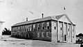
Stafford County Courthouse in 1929

See also
 In Spanish: Condado de Stafford (Virginia) para niños
