
Starke, Florida facts for kids
Quick facts for kids
Starke, Florida
|
|
|---|---|

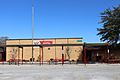
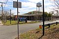
From top, left to right: Bradford County Courthouse, Starke water tower, Old Bradford County Bank, Old Bradford County Courthouse, Florida Twin Theatre, Railroad tracks running through Call Street Historic District
|
|

Location in Bradford County and the state of Florida
|
|
| Country | |
| State | |
| County | Bradford |
| Government | |
| • Type | Commission-Manger |
| Area | |
| • Total | 7.18 sq mi (18.59 km2) |
| • Land | 7.18 sq mi (18.59 km2) |
| • Water | 0.00 sq mi (0.00 km2) |
| Elevation | 167 ft (51 m) |
| Population
(2020)
|
|
| • Total | 5,796 |
| • Density | 807.47/sq mi (311.74/km2) |
| Time zone | UTC-5 (Eastern (EST)) |
| • Summer (DST) | UTC-4 (EDT) |
| ZIP code |
32091
|
| Area code(s) | 904 |
| FIPS code | 12-68525 |
| GNIS feature ID | 0291634 |
Starke is a city in and the county seat of Bradford County, Florida, United States. The population was 5,796 at the 2020 census.
Starke may have been named in honor of developer George W. Cole's fiancée or in honor of Madison Starke Perry, fourth governor of Florida and a Confederate States Army colonel. The Florida Department of State, Division of Historical Resources, adds that the city may have been named after "Thomas Starke, a slaveholder who once owned much land around the area."
Geography
Starke is located in east-central Bradford County at 29°56′50″N 82°6′29″W / 29.94722°N 82.10806°W (29.947155, -82.108113). U.S. Route 301 passes through the center of the city, leading north 26 miles (42 km) to Baldwin and Interstate 10 and southwest (via State Road 24) 25 miles (40 km) to Gainesville.
According to the United States Census Bureau, the city has a total area of 7.2 square miles (18.7 km2), all land.
Starke is located approximately 8 miles (13 km) west of Florida's National Guard base, Camp Blanding, and is approximately 10 miles (16 km) southeast of Florida State Prison, Union Correctional Institution, and New River East Correctional Institution.
Demographics
| Historical population | |||
|---|---|---|---|
| Census | Pop. | %± | |
| 1880 | 292 | — | |
| 1890 | 669 | 129.1% | |
| 1900 | 972 | 45.3% | |
| 1910 | 1,135 | 16.8% | |
| 1920 | 1,023 | −9.9% | |
| 1930 | 1,339 | 30.9% | |
| 1940 | 1,480 | 10.5% | |
| 1950 | 2,944 | 98.9% | |
| 1960 | 4,806 | 63.2% | |
| 1970 | 4,848 | 0.9% | |
| 1980 | 5,306 | 9.4% | |
| 1990 | 5,226 | −1.5% | |
| 2000 | 5,593 | 7.0% | |
| 2010 | 5,449 | −2.6% | |
| 2020 | 5,796 | 6.4% | |
| U.S. Decennial Census | |||
As of the census of 2000, there were 5,593 people, 2,003 households, and 1,350 families residing in the city. The population density was 839.3 people per square mile (324.2/km2). There were 2,273 housing units at an average density of 341.1 per square mile (131.8/km2). The racial makeup of the city was 67.05% White, 29.54% African American, 0.21% Native American, 1.25% Asian, 0.16% Pacific Islander, 0.64% from other races, and 1.14% from two or more races. Hispanic or Latino of any race were 2.23% of the population.
There were 2,003 households, out of which 32.7% had children under the age of 18 living with them, 43.3% were married couples living together, 20.0% had a female householder with no husband present, and 32.6% were non-families. 28.0% of all households were made up of individuals, and 13.6% had someone living alone who was 65 years of age or older. The average household size was 2.57 and the average family size was 3.14.
In the city, the population was spread out, with 26.7% under the age of 18, 9.7% from 18 to 24, 25.1% from 25 to 44, 20.3% from 45 to 64, and 18.1% who were 65 years of age or older. The median age was 36 years. For every 100 females, there were 86.2 males. For every 100 females age 18 and over, there were 81.1 males.
The median income for a household in the city was $27,021, and the median income for a family was $35,093. Males had a median income of $27,176 versus $17,986 for females. The per capita income for the city was $13,507. About 19.2% of families and 23.9% of the population were below the poverty line, including 34.9% of those under age 18 and 23.2% of those age 65 or over.
Point of Interest
The Starke post office contains a mural, Reforestation, painted in 1940 by Elizabeth Terell. Murals were produced from 1934 to 1943 in the United States through the Section of Painting and Sculpture, later called the Section of Fine Arts, of the Treasury Department. The WPA was the largest and most ambitious American New Deal agency, employing individuals to carry out public works projects.
Education

Bradford County School District operates public schools.
- Bradford High School
- Bradford Middle School
- Starke Elementary School
- Southside Elementary School
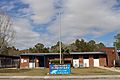
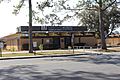
North Florida Technical College (Bradford-Union Technical Center), a tertiary institution managed by the school district, is in Starke. Santa Fe Community College's Andrews Center campus is located in the historic Old Bradford County Courthouse. The Romanesque style brick courthouse, with its restored yet original clock tower was constructed in 1902 and added to the U.S. National Register of Historic Places on December 27, 1974. The courthouse lies within the Call Street Historic District and is considered the center of downtown Starke.
Bradford County Public Library is in Starke. It is a part of the New River Public Library Cooperative.
-
Bradford Middle School
-
Starke Elementary School
-
Southside Elementary School
-
Bradford-Union Technical Center
-
Bradford County Public Library


Notable people
- Judy Canova, film actress and entertainer, was born in Starke
- Doyle Edward Conner Sr, Florida politician, was born in Starke
- Charley Eugene Johns, 32nd Governor of Florida
See also
 In Spanish: Starke (Florida) para niños
