
Administrative divisions of Mexico facts for kids
The United Mexican States (Spanish: Estados Unidos Mexicanos) is a federal republic formed by 32 federal entities (Spanish: entidades federativas) (31 states and 1 federal district).
According to the Constitution of 1917, the states of the federation are free and sovereign. Each state has their own congress and constitution, but the Federal District has only limited autonomy with a local Congress and government. The territory of the Federal District, commonly known as Mexico City, serves as the national capital.
Divisions of Mexico

Federal district
| Entity | Official Name | Flag | Area | Population (2010) | Date of establishment |
|---|---|---|---|---|---|
| Ciudad de México | Distrito Federal |  |
1,485 km2 (573.4 sq mi) |
8,720,916 | 1824-11-18 |
States
| State | Official Name
Estado Libre y Soberano de: |
Flag | Capital | Largest city | Area | Population (2010) | Order of Admission to Federation |
Date of Admission to Federation |
|---|---|---|---|---|---|---|---|---|
| Aguascalientes | Aguascalientes | Aguascalientes | Aguascalientes | 5,618 km2 (2,169 sq mi) | 1,184,996 | 24 | 1857-02-05 | |
| Baja California | Baja California | Mexicali | Tijuana | 71,446 km2 (27,585 sq mi) | 3,155,070 | 29 | 1952-01-16 | |
| Baja California Sur | Baja California Sur | La Paz | La Paz | 73,922 km2 (28,541 sq mi) | 637,026 | 31 | 1974-10-08 | |
| Campeche | Campeche | San Francisco de Campeche | San Francisco de Campeche | 57,924 km2 (22,365 sq mi) | 822,441 | 25 | 1863-04-29 | |
| Chiapas | Chiapas | Tuxtla Gutiérrez | Tuxtla Gutiérrez | 73,289 km2 (28,297 sq mi) | 4,796,580 | 19 | 1824-09-14 | |
| Chihuahua | Chihuahua | Chihuahua | Ciudad Juárez | 247,455 km2 (95,543 sq mi) | 3,406,465 | 18 | 1824-07-06 | |
| Coahuila1 4 | Coahuila de Zaragoza | Saltillo | Torreón | 151,563 km2 (58,519 sq mi) | 2,748,391 | 16 | 1824-05-07 | |
| Colima | Colima | Colima | Manzanillo | 5,625 km2 (2,172 sq mi) | 650,555 | 23 | 09-12-1856 | |
| Durango | Durango | Victoria de Durango | Victoria de Durango | 123,451 km2 (47,665 sq mi) | 1,632,934 | 17 | 1824-05-22 | |
| Guanajuato | Guanajuato | Guanajuato | León | 30,608 km2 (11,818 sq mi) | 5,486,372 | 2 | 1823-12-20 | |
| Guerrero | Guerrero | Chilpancingo de los Bravo |
Acapulco de Juárez | 63,621 km2 (24,564 sq mi) | 3,388,768 | 21 | 1849-10-27 | |
| Hidalgo | Hidalgo | Pachuca de Soto | Pachuca de Soto | 20,846 km2 (8,049 sq mi) | 2,665,018 | 26 | 1869-01-16 | |
| Jalisco | Jalisco | Guadalajara | Guadalajara | 78,599 km2 (30,347 sq mi) | 7,350,682 | 9 | 1823-12-23 | |
| México | México | Toluca de Lerdo | Ecatepec de Morelos | 22,357 km2 (8,632 sq mi) | 15,175,862 | 1 | 1823-12-20 | |
| Michoacán | Michoacán de Ocampo | Morelia | Morelia | 58,643 km2 (22,642 sq mi) | 4,351,037 | 5 | 1823-12-22 | |
| Morelos | Morelos | Cuernavaca | Cuernavaca | 4,893 km2 (1,889 sq mi) | 1,777,227 | 27 | 1869-04-17 | |
| Nayarit | Nayarit | Tepic | Tepic | 27,815 km2 (10,739 sq mi) | 1,084,979 | 28 | 1917-01-26 | |
| Nuevo León4 | Nuevo León | Monterrey | Monterrey | 64,220 km2 (24,800 sq mi) | 4,653,458 | 15 | 1824-05-07 | |
| Oaxaca | Oaxaca | Oaxaca de Juárez | Oaxaca de Juárez | 93,793 km2 (36,214 sq mi) | 3,801,962 | 3 | 1823-12-21 | |
| Puebla | Puebla | Puebla de Zaragoza | Puebla de Zaragoza | 34,290 km2 (13,240 sq mi) | 5,779,829 | 4 | 1823-12-21 | |
| Querétaro | Querétaro | Santiago de Querétaro | Santiago de Querétaro | 11,684 km2 (4,511 sq mi) | 1,827,937 | 11 | 1823-12-23 | |
| Quintana Roo | Quintana Roo | Chetumal | Cancún | 42,361 km2 (16,356 sq mi) | 1,325,578 | 30 | 1974-10-08 | |
| San Luis Potosí | San Luis Potosí | San Luis Potosí | San Luis Potosí | 60,983 km2 (23,546 sq mi) | 2,585,518 | 6 | 1823-12-22 | |
| Sinaloa | Sinaloa | Culiacán | Culiacán | 57,377 km2 (22,153 sq mi) | 2,767,761 | 20 | 1830-10-14 | |
| Sonora2 | Sonora | Hermosillo | Hermosillo | 179,503 km2 (69,306 sq mi) | 2,662,480 | 12 | 1824-01-10 | |
| Tabasco5 | Tabasco | Villahermosa | Villahermosa | 24,738 km2 (9,551 sq mi) | 2,238,603 | 13 | 1824-02-07 | |
| Tamaulipas4 | Tamaulipas | Ciudad Victoria | Reynosa | 80,175 km2 (30,956 sq mi) | 3,268,554 | 14 | 1824-02-07 | |
| Tlaxcala | Tlaxcala | Tlaxcala de Xicoténcatl | Vicente Guerrero | 3,991 km2 (1,541 sq mi) | 1,169,936 | 22 | 1856-12-09 | |
| Veracruz | Veracruz de Ignacio de la Llave |
Xalapa | Veracruz | 71,820 km2 (27,730 sq mi) | 7,643,194 | 7 | 1823-12-22 | |
| Yucatán3 | Yucatán | Mérida | Mérida | 39,612 km2 (15,294 sq mi) | 1,955,577 | 8 | 1823-12-23 | |
| Zacatecas | Zacatecas | Zacatecas | Zacatecas | 75,539 km2 (29,166 sq mi) | 1,490,668 | 10 | 1823-12-23 |
Notes:
- Joined the federation with the name of Coahuila y Texas.
- Joined the federation with the name of Estado de Occidente also recognized as Sonora y Sinaloa.
- Joined the federation as República Federada de Yucatán (English: Federated Republic of Yucatán) formed by the current states of Yucatan, Campeche and Quintana Roo. Became independent in 1841 constituting the second Republic of Yucatán and definitely rejoined in 1848.
- States of Nuevo León, Tamaulipas and Coahuila became independent de facto in 1840 to form the República del Río Grande (English: Republic of the Rio Grande); never consolidated its independence because independent forces were defeated by the centralist forces.
- State of Tabasco seceded from Mexico on two occasions, the first on February 13, 1841, rejoining again on December 2, 1842. And the second time was from November 9, 1846 to December 8 of that year.
Related pages
- Administrative division
- List of Latin American subnational entities by HDI
- List of Mexican state demonyms
- List of Mexican state governors
- List of Mexican states by area
- List of Mexican states by HDI
- List of Mexican states by population
- Mexican state name etymologies
- Ranked list of Mexican states
- State governments of Mexico
- Territorial evolution of Mexico
- Political Constitution of the United Mexican States; articles 2, and 42 through 48
- Law of Linguistic Rights or "Ley de los Derechos Lingüísticos" approved in 2001.juihu b
Images for kids
-
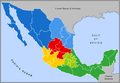
Typical (unofficial) regional grouping of the Mexican states.
-
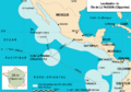
Location of Socorro Island and the rest of the Revillagigedo Archipelago, and extent of Mexico's western EEZ in the Pacific. The islands are part of Colima state, but under federal jurisdiction.


See also
 In Spanish: Organización territorial de México para niños
