
Steeles Avenue facts for kids
Quick facts for kids
|
|||||||
|---|---|---|---|---|---|---|---|
| Lua error in Module:Infobox_road/map at line 15: attempt to index field 'wikibase' (a nil value). | |||||||
| Major junctions | |||||||
| West end | Milborough Townline | ||||||
| East end | Scarbough Pickering Townline | ||||||
| Location | |||||||
| Major cities: | Toronto | ||||||
| Highway system | |||||||
Roads in Ontario
|
|||||||


Steeles Avenue is an east-west street that forms the northern city border of Toronto and the southern border of York Region, Ontario, Canada. It is 38.75 km within Toronto, between Albion Road and the Scarborough-Pickering border.
West of Albion Road, Steeles continues into Peel Region, where it is also known as Peel Regional Road 15. It runs through Brampton and into the Halton Region town of Milton. It stops at Appleby Line on top of the Niagara Escarpment due to the Crawford Lake Conservation Area being there, and then the road starts again just east of Guelph Line and goes until the Milborough Townline on the border of Milton and Hamilton. East of the Toronto-Pickering border, it becomes Taunton Road.
Contents
Name
Steeles is named after J. C. Steele, who owned a tavern on the street where it joins with Yonge Street.
Ontario's Worst Road
Steeles Avenue was listed as the worst road by the CAA in October 2006, and as the fifth worst road in October 2007. In October 2008, it was re-listed as worst road in Ontario. Reasons are potholes and the quality of the road. Soon after the CAA's listing, some parts of the road between Dufferin Street and Bayview Avenue were resurfaced.
Landmarks
Landmarks and notable sites along Steeles from west to east
| Landmark | Cross street | Notes | Image |
|---|---|---|---|
| Crawford Lake Conservation Area | Guelph Line | Former separate section of road west of Guelph Line now known as Conservation Road |  |
| Rattlesnake Point | Appleby Line, Guelph Line | Road now officially begins at Appleby Line |  |
| Toronto Premium Outlets | Trafalgar Road | First Premium Outlets Center in Canada | |
| Sheridan College-Davis Campus | McLaughlin Road | Sheridan’s largest campus, educating nearly 8,000 students. |  |
| Shoppers World Brampton | Hurontario Street | Road becomes Steeles West and Steeles East |  |
| Bramalea GO Station | Bramalea Road |  |
|
| Wet 'n' Wild Toronto | Finch Avenue West | Canada's largest waterpark | |
| Black Creek Pioneer Village | Jane Street |  |
|
| Pioneer Village station | Northwest Gate |  |
|
| York University | Keele Street, Founders Road, Murray Ross Parkway | Toronto's second largest university | .jpg) |
| Centerpoint Mall | Yonge Street | Formerly Towne and Countrye Square |  |
| Brebeuf College School | Conacher Drive |  |
|
| Pacific Mall | Kennedy Road | largest indoor Chinese Asian mall in North America |  |
| Market Village | Kennedy Road, Redlea Avenue | Currently closed on March 1, 2018. To be replaced by Remington Centre |  |
| Splendid China Mall | Kennedy Road, Redlea Avenue | Former Canadian Tire store |  |
| Milliken GO Station | Old Kennedy Road, Silverstar Boulevard | Station moved across the street from Markham to Toronto |  |
| Cedar Brae Golf & Country Club | Staines Road | Road enters Rouge Park. Formerly Cedar Brook Golf and Country Club c. 1922 | |
| Menno-Reesor House (6461 Steeles Avenue East) | Littles Road | Home and barn will be renovated as part of the Toronto Wildlife Centre development |
Images for kids
-
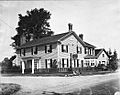
The Green Bush Inn at Yonge and Steeles; circa 1920
-
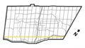
Steeles Ave. in Brampton
-
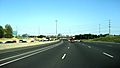
Highway 404 southbound approaching interchange with Steeles Avenue, circa 2007.


