
Steubenville, Ohio facts for kids
Quick facts for kids
Steubenville, Ohio
|
||
|---|---|---|
| City of Steubenville | ||

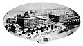
Steubenville skyline
|
||
|
||
| Nickname(s):
"City of Murals"
|
||
| Motto(s):
Where you always have a home
|
||

Location of Steubenville in Jefferson County and the state of Ohio
|
||
| Country | United States | |
| State | Ohio | |
| County | Jefferson | |
| Founded | 1795 | |
| Government | ||
| • Type | Council-Manager | |
| Area | ||
| • City | 10.62 sq mi (27.50 km2) | |
| • Land | 10.54 sq mi (27.29 km2) | |
| • Water | 0.08 sq mi (0.21 km2) | |
| Elevation | 1,050 ft (320 m) | |
| Population
(2020)
|
||
| • City | 18,161 | |
| • Density | 1,710.08/sq mi (660.40/km2) | |
| • Metro | 118,250 (US: 329th) | |
| • CSA | 2,659,937 (US: 20th) | |
| Time zone | UTC-5 (EST) | |
| • Summer (DST) | UTC-4 (EDT) | |
| ZIP codes |
43952-43953
|
|
| Area code(s) | 740, 220 | |
| FIPS code | 39-74608 | |
| GNIS feature ID | 1065383 | |

Steubenville is a city in and the county seat of Jefferson County, Ohio, United States. Located along the Ohio River 33 miles from Pittsburgh, it had a population of 18,161 at the 2020 census. The city's name is derived from Fort Steuben, a 1786 fort that sat within the city's current limits and was named for Prussian military officer Baron Friedrich Wilhelm von Steuben. Today, a replica of the fort is open to the public.
Steubenville's nickname is the "City of Murals", after its more than 25 downtown murals. Both the campuses of Franciscan University of Steubenville and Eastern Gateway Community College are in Steubenville. Historically, it was known as the birthplace and home town of Edwin Stanton, Secretary of War during the American Civil War. It is also known as the city where legendary entertainer Dean Martin of the Rat Pack was born and raised. It is recently gaining notoriety for the Steubenville Nutcracker Village, an annual Christmastime event. Steubenville is a principal city of the Weirton–Steubenville, WV-OH Metropolitan Statistical Area, which had a 2010 population of 124,454 residents.
Contents
History


In 1786–87, the soldiers of the 1st American Regiment built Fort Steuben to protect the government surveyors mapping the land west of the Ohio River, and named the fort in honor of Baron Friedrich Wilhelm von Steuben. When the surveyors completed their task a few years later, the fort was abandoned. In the meantime, settlers had built homes around the fort; they named their settlement Steubenville. The name Steubenville was derived from Fort Steuben to honor Baron von Steuben (the fort was named for the Baron). The town was sometimes referred to as La Belle City, a franglais interpretation of "The Beautiful City".
On July 29, 1797, Jefferson County was organized by a proclamation of Governor Arthur St. Clair, and Steubenville was selected as the County seat and was platted in the same year by Bezaliel (Bezaleel) Wells and James Ross, the city's co-founders. Wells, a government surveyor born in Baltimore, received about 1,000 acres (4 km2) of land west of the Ohio River; Ross, a lawyer from Pittsburgh, owned land north of his.
On March 1, 1803, Ohio was admitted to the Union as the 17th state. During the first half of the nineteenth century, Steubenville was primarily a port town, and the rest of the county was small villages and farms. Steubenville received a city charter in 1851. In 1856, Frazier, Kilgore and Company erected a rolling mill (the forerunner of steel mills) and the Steubenville Coal and Mining Company sank a coal shaft. The city was a stop along the Pittsburgh, Cincinnati, Chicago and St. Louis Railroad, which connected Pittsburgh to Chicago and St. Louis.
In 1946, the College of Steubenville was founded by the Franciscan Friars of the Third Order Regular. In 1980, its name was changed to University of Steubenville, and finally in 1985 to Franciscan University of Steubenville.
In 1966, the Jefferson County Technical Institute was founded. In 1977, its name was changed to Jefferson Technical College. In 1995, it became a community college and was renamed Jefferson Community College. In 2009, the college expanded its service district by three Ohio counties, and was renamed again: Eastern Gateway Community College.
Geography

Steubenville is located at 40°21′30″N 80°37′0″W / 40.35833°N 80.61667°W (40.359, −80.614). According to the United States Census Bureau, the city has a total area of 10.63 square miles (27.53 km2), of which 10.55 square miles (27.32 km2) is land and 0.08 square miles (0.21 km2) is water. The city lies along the Ohio River, with the city spreading west from the floodplains to the hills that surround the city. It lies within the ecoregion of the Western Allegheny Plateau.
Demographics
| Historical population | |||
|---|---|---|---|
| Census | Pop. | %± | |
| 1800 | 731 | — | |
| 1810 | 1,617 | 121.2% | |
| 1820 | 2,479 | 53.3% | |
| 1830 | 2,987 | 20.5% | |
| 1840 | 4,247 | 42.2% | |
| 1850 | 6,140 | 44.6% | |
| 1860 | 6,154 | 0.2% | |
| 1870 | 8,107 | 31.7% | |
| 1880 | 12,093 | 49.2% | |
| 1890 | 13,394 | 10.8% | |
| 1900 | 14,349 | 7.1% | |
| 1910 | 22,391 | 56.0% | |
| 1920 | 28,508 | 27.3% | |
| 1930 | 35,422 | 24.3% | |
| 1940 | 37,651 | 6.3% | |
| 1950 | 35,872 | −4.7% | |
| 1960 | 32,495 | −9.4% | |
| 1970 | 30,771 | −5.3% | |
| 1980 | 26,400 | −14.2% | |
| 1990 | 22,125 | −16.2% | |
| 2000 | 19,015 | −14.1% | |
| 2010 | 18,659 | −1.9% | |
| 2020 | 18,161 | −2.7% | |
| Sources: | |||
The city's population peaked in 1940 and has been in continuous decline since. The 2010 census found 18,659 residents, down 1.8 percent from the 2000 census, while the 2011 estimate put the population at 18,440, a drop of another 1.2 percent since 2010. The poverty rate increased to 27.5 percent of the population. The proportion of the population that is white remained at 79.5 percent, while the Hispanic proportion more than doubled to 2.4 percent as the black population dropped to 15.9 percent.
From 1980 to 2000, census figures show that the Weirton–Steubenville population decreased faster than that of any other urban area in the United States.
Steubenville is a principal city of the Weirton–Steubenville, WV–OH Metropolitan Statistical Area, part of the Pittsburgh-New Castle-Weirton, PA-OH-WV Combined Statistical Area.
2010 census
As of the census of 2010, there were 18,659 people, 7,548 households, and 4,220 families residing in the city. The population density was 1,768.6 inhabitants per square mile (682.9/km2). There were 8,857 housing units at an average density of 839.5 per square mile (324.1/km2). The racial makeup of the city was 79.0% White, 15.9% African American, 0.2% Native American, 0.8% Asian, 0.6% from other races, and 3.5% from two or more races. Hispanic or Latino of any race were 2.4% of the population.
There were 7,548 households, of which 25.3% had children under the age of 18 living with them, 34.8% were married couples living together, 16.2% had a female householder with no husband present, 4.8% had a male householder with no wife present, and 44.1% were non-families. 37.1% of all households were made up of individuals, and 15.7% had someone living alone who was 65 years of age or older. The average household size was 2.22 and the average family size was 2.91.
The median age in the city was 38.8 years. 20.3% of residents were under the age of 18; 16.1% were between the ages of 18 and 24; 20.3% were from 25 to 44; 25.9% were from 45 to 64; and 17.5% were 65 years of age or older. The gender makeup of the city was 46.1% male and 53.9% female.
Culture
Historic sites
Fort Steuben, located downtown on South Third Street, is a reconstructed 18th century fort on its original location overlooking the Ohio River. Built in 1787 to protect the government surveyors of the Seven Ranges of the Northwest Territory, Fort Steuben housed 150 men of the 1st American Regiment. The non-profit organization that worked to rebuild the fort also developed the surrounding block into Fort Steuben Park that includes the Veterans Memorial Fountain and the Berkman Amphitheater. The Fort Steuben Visitors center is home to the Museum Shop and the Steubenville Convention & Visitors Bureau and is an official site on the Ohio River Scenic Byway.
Adjacent to the fort is the First Federal Land Office with its original logs from 1801. After the Ohio country was surveyed, it could be sold or given away as land grants; the settlers brought their deeds to be registered at the Land Office to David Hoge, the Registrar of Lands and Titles for the Northwest Territory.
"Ohio Valley Steelworker" Statue was created by artist Dimitri Akis as a tribute to the Ohio Valley Steelworkers. The life-size figure carries a long-handled dipping ladle and is wearing the hooded fire-proof suit worn in the steel mills. The statue was located at the junction of Hwy 22 (University Blvd) and Hwy 7 (Dean Martin Blvd). In the fall of 2014, the statue was moved to its new home, displayed on South Fourth Street at the site of the Public Library of Steubenville and Jefferson County.
There is a statue downtown commemorating Edwin Stanton, President Abraham Lincoln's secretary of war. Stanton was born and raised in Steubenville.
Parks and recreation
City parks
The Steubenville Parks and Recreation Department maintains over twenty parks and recreation facilities within the City. Belleview Park is the crown jewel of the department featuring five lighted softball/baseball fields, public swimming pool, tennis courts,playgrounds and shelter areas. Beatty Park, located in the south side of Steubenville is the largest of the city parks. The facility features include hiking trails, picnic shelters, a disc golf course and bird watching. North End Park, located on 7th street, features a softball diamond, new (as of 2016) playgrounds, and a picnic area. Jim Wood Park located off John Scott Highway features a walking/jogging track, baseball/softball diamond, picnic areas and splash pad. The Martin Luther King Recreation Center, located at 905 Market Street is a free facility for residents of the city to enjoy basketball, programs and activities, a meeting/activity space as well as the offices to the Parks and Recreation Department. Murphy's Field/Rotary Park located off Plum Street, features a baseball diamond, shelter house and playground. Several smaller tot lot type parks dot the city. The department employs one full time staff member, a director and three part time recreation aides. Maintenance of the parks and facilities was turned over to the M&R Department in the fall of 2016. Previously the work was completed by two full time maintenance workers. The department hosts a variety of programs during the year including Daddy Daughter Date Night, Community Halloween Party and Breakfast with Santa. Smaller programs are held throughout the year at various park locations.
Climate
The climate in this area is characterized by relatively high temperatures and evenly distributed precipitation throughout the year. According to the Köppen Climate Classification system, Steubenville has a Humid subtropical climate, abbreviated "Cfa" on climate maps.
| Climate data for Steubenville, Ohio | |||||||||||||
|---|---|---|---|---|---|---|---|---|---|---|---|---|---|
| Month | Jan | Feb | Mar | Apr | May | Jun | Jul | Aug | Sep | Oct | Nov | Dec | Year |
| Average high °C (°F) | 3 (37) |
5 (41) |
11 (51) |
17 (63) |
23 (73) |
27 (81) |
29 (84) |
28 (83) |
24 (76) |
18 (65) |
11 (52) |
5 (41) |
17 (62) |
| Average low °C (°F) | −6 (21) |
−6 (22) |
−1 (30) |
4 (39) |
9 (49) |
14 (58) |
17 (62) |
16 (61) |
13 (55) |
6 (43) |
1 (34) |
−4 (24) |
6 (42) |
| Average precipitation cm (inches) | 7.6 (3) |
6.4 (2.5) |
9.4 (3.7) |
8.9 (3.5) |
10 (4.1) |
11 (4.2) |
11 (4.2) |
8.9 (3.5) |
8.1 (3.2) |
7.1 (2.8) |
7.6 (3) |
7.6 (3) |
103 (40.6) |
| Source: Weatherbase | |||||||||||||
Economy
.jpg)
Steubenville and the communities that surround it, especially Weirton, West Virginia, have experienced sluggish economies since the steel industry waned during the 1980s. Corporations such as Weirton Steel have had to reduce their workforce in order to become more efficient and competitive against other steel producers and lower steel prices worldwide.
Starting in 2014, the Harmonium Project and numerous others partners began a series of street festivals called Fridays on Fourth to building community and generate interest and economic activity downtown. More recently there have been several new businesses opened on 4th Street in Downtown Stuebenville in recent years, including Drosselmeyer’s Nutcracker Shoppe, Leonardo’s Coffeehouse and the Steubenville Popcorn Co.
The new Findlay Connector has been built in western Pennsylvania as a toll-access highway between Pittsburgh International Airport at Interstate 376 and U.S. Route 22 in northwestern Washington County. Travel time between the Pittsburgh International Airport and the city of Steubenville is now approximately 25 minutes.
Steubenville is located near two large shale formations: the Marcellus and Utica formations.
Sports
The Steubenville Stampede was a member of the Continental Indoor Football League.
Education
_1911.jpg)
Colleges and universities
Steubenville is home to two institutions of higher education. The Franciscan University of Steubenville is a private, four-year university affiliated with the Roman Catholic Church. It was founded in 1946.
The second institution is Eastern Gateway Community College. It is a public, two-year college that opened its doors in 1968; its service district includes Columbiana, Mahoning, and Trumbull Counties as well as Jefferson County.
On July 24, 2012, after being threatened with a lawsuit from the atheist Freedom from Religion Foundation, the Steubenville city council decided to remove the image of Franciscan University from its town logo rather than pay for a lawsuit. The city later proposed a logo that included a chapel and cross.
Public schools
Public schools in Steubenville are operated by the Steubenville City School District. There are a total of five schools in the district: Wells Academy, West Pugliese, Garfield, Harding Middle, and Steubenville High School. A portion of far western Steubenville is served by the Indian Creek Local School District.
Private schools
Several private schools are located in Steubenville. The Roman Catholic Diocese of Steubenville operates Bishop John King Mussio Central Elementary School, Bishop John King Mussio Central Junior High School and Steubenville Catholic Central High School.
Public libraries
Steubenville has two public lending libraries, the main branch and Schiappa Branch Library.
Notable people
Images for kids
-
Ohio Valley Clay Company, 1910
-

The Veterans Memorial Bridge connects Steubenville to Weirton, West Virginia, across the Ohio River and is the border crossing between the states of West Virginia and Ohio on U.S. Highway 22.
-
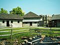
An archaeological dig on the grounds of the reconstructed Fort Steuben.
-

A mural of entertainer Dean Martin, who was born and raised in Steubenville.


See also
 In Spanish: Steubenville (Ohio) para niños
