
Stewart, British Columbia facts for kids
Quick facts for kids
Stewart
|
|
|---|---|
|
District municipality
|
|
| District of Stewart | |
 |
|

Stewart
Location in British Columbia
|
|
| Country | |
| Province | |
| Regional District | Kitimat-Stikine |
| Incorporated | 1930 |
| Area | |
| • Total | 552.08 km2 (213.16 sq mi) |
| Elevation | 0 m (0 ft) |
| Population
(2016)
|
|
| • Total | 401 |
| • Density | 0.7263/km2 (1.8812/sq mi) |
| Time zone | UTC−8 (PST) |
| Postal Code |
V0T 1W0
|
| Area code(s) | 250, 778, 236 |
| Highways | Hwy 37A |
Stewart is a small Canadian town in British Columbia, Canada. The population of Stewart at the 2006 census was 496. The town originally had a population of around 10,000 people before to World War I, it then declined to about 700 people in 2000. As of 2005, its population had declined to less than 500 people. The town was named Stewart by Robert M. Stewart in 1905. Nearby is the town of Hyder in the United States state of Alaska.
Images for kids
-
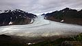
Salmon Glacier in British Columbia, a popular tourist destination.
-
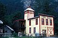
Fire hall in Stewart


All content from Kiddle encyclopedia articles (including the article images and facts) can be freely used under Attribution-ShareAlike license, unless stated otherwise. Cite this article:
Stewart, British Columbia Facts for Kids. Kiddle Encyclopedia.