Stewart County, Tennessee facts for kids
Quick facts for kids
Stewart County
|
|
|---|---|

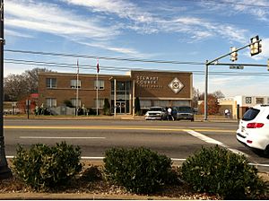
Stewart County courthouse
|
|

Location within the U.S. state of Tennessee
|
|
 Tennessee's location within the U.S. |
|
| Country | |
| State | |
| Founded | 1803 |
| Named for | Duncan Stewart |
| Seat | Dover |
| Largest city | Dover |
| Area | |
| • Total | 493 sq mi (1,280 km2) |
| • Land | 459 sq mi (1,190 km2) |
| • Water | 34 sq mi (90 km2) 6.8%% |
| Population
(2020)
|
|
| • Total | 13,657 |
| • Density | 29/sq mi (11/km2) |
| Time zone | UTC−6 (Central) |
| • Summer (DST) | UTC−5 (CDT) |
| Congressional district | 7th |
Stewart County is a county located on the northwestern corner of Middle Tennessee, in the U.S. state of Tennessee. As of the 2010 census, the population was 13,324. Its county seat is Dover. Stewart County is part of the Clarksville Metropolitan Statistical Area.
Contents
History
Stewart County was created in 1803 from a portion of Montgomery County, and was named for Duncan Stewart, an early settler and state legislator. During the Battle of Fort Donelson, the county seat, Dover, was burned by Union troops to prevent its capture by General Nathan B. Forrest.
Tobaccoport Saltpeter Cave was intensely mined for saltpeter, possibly during the War of 1812. Saltpeter is the main ingredient of gunpowder and was obtained by leaching the earth from the cave. This area fell under Union control in February 1862, early in the Civil War, and it seems unlikely that mining could have happened before that.
Geography
According to the U.S. Census Bureau, the county has a total area of 493 square miles (1,280 km2), of which 459 square miles (1,190 km2) is land and 34 square miles (88 km2) (6.8%) is water. The county lies in a rugged section of the northwestern Highland Rim. The Cumberland River (part of Lake Barkley) traverses the county. The Tennessee River (part of Kentucky Lake) provides the county's border with Henry County to the west.
Federal and state agencies control nearly 44% of the land in the county.
Adjacent counties
- Trigg County, Kentucky (north)
- Christian County, Kentucky (northeast)
- Montgomery County (east)
- Houston County (south)
- Benton County (southwest)
- Henry County (west)
- Calloway County, Kentucky (northwest)
National protected areas
- Cross Creeks National Wildlife Refuge
- Fort Donelson National Battlefield (part)
- Land Between the Lakes National Recreation Area (part)
State protected areas
- Barkley Wildlife Management Area
- Stewart State Forest
Demographics
| Historical population | |||
|---|---|---|---|
| Census | Pop. | %± | |
| 1810 | 4,262 | — | |
| 1820 | 8,397 | 97.0% | |
| 1830 | 6,968 | −17.0% | |
| 1840 | 8,587 | 23.2% | |
| 1850 | 9,719 | 13.2% | |
| 1860 | 9,896 | 1.8% | |
| 1870 | 12,019 | 21.5% | |
| 1880 | 12,690 | 5.6% | |
| 1890 | 12,193 | −3.9% | |
| 1900 | 15,224 | 24.9% | |
| 1910 | 14,860 | −2.4% | |
| 1920 | 14,664 | −1.3% | |
| 1930 | 13,278 | −9.5% | |
| 1940 | 13,549 | 2.0% | |
| 1950 | 9,175 | −32.3% | |
| 1960 | 7,851 | −14.4% | |
| 1970 | 7,319 | −6.8% | |
| 1980 | 8,665 | 18.4% | |
| 1990 | 9,479 | 9.4% | |
| 2000 | 12,370 | 30.5% | |
| 2010 | 13,324 | 7.7% | |
| 2018 (est.) | 13,561 | 1.8% | |
| U.S. Decennial Census 1790-1960 1900-1990 1990-2000 2010-2014 |
|||
2020 census
| Race | Number | Percentage |
|---|---|---|
| White (non-Hispanic) | 12,321 | 90.22% |
| Black or African American (non-Hispanic) | 171 | 1.25% |
| Native American | 74 | 0.54% |
| Asian | 76 | 0.56% |
| Pacific Islander | 2 | 0.01% |
| Other/Mixed | 677 | 4.96% |
| Hispanic or Latino | 336 | 2.46% |
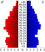
As of the 2020 United States census, there were 13,657 people, 5,178 households, and 3,355 families residing in the county.
Communities
City
- Dover (county seat)
Towns
- Cumberland City
- Tennessee Ridge (mostly in Houston County)
Unincorporated communities
See also
 In Spanish: Condado de Stewart (Tennessee) para niños


