Stillwater River (Flathead County, Montana) facts for kids
This page is about Stillwater River, Flathead County, Montana. For Stillwater River, Stillwater County, Montana, see Stillwater River (Stillwater County, Montana).
Quick facts for kids Stillwater River |
|
|---|---|

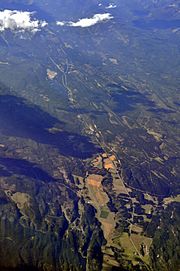
Aerial view of Stillwater River valley from the south (August 2013) with Lower Stillwater Lake slightly above the center of the image
|
|
| Country | Flathead and Lincoln County, Montana |
| Physical characteristics | |
| Main source | 48°48′06″N 114°42′43″W / 48.80167°N 114.71194°W |
| River mouth | 2,897 feet (883 m) 48°09′54″N 114°15′39″W / 48.16500°N 114.26083°W |
| Basin features | |
| River system | Columbia River |
The Stillwater River rises 15 miles south of the border between Montana (United States) and Alberta (Canada), west of Glacier National Park in the Kootenai National Forest. It runs mainly south to Duck Lake, then Upper Stillwater Lake, Lagoni Lake and on to Lower Stillwater Lake. It then flows south to Kalispell where it joins the Whitefish River, very near where that river enters the Flathead River.

All content from Kiddle encyclopedia articles (including the article images and facts) can be freely used under Attribution-ShareAlike license, unless stated otherwise. Cite this article:
Stillwater River (Flathead County, Montana) Facts for Kids. Kiddle Encyclopedia.
