
Stockton Springs, Maine facts for kids
Quick facts for kids
Stockton Springs, Maine
|
|
|---|---|

|
|

Location of Stockton Springs (in yellow) in Waldo County and the state of Maine
|
|
| Country | United States |
| State | Maine |
| County | Waldo |
| Incorporated | 1857 |
| Area | |
| • Total | 29.83 sq mi (77.26 km2) |
| • Land | 19.64 sq mi (50.87 km2) |
| • Water | 10.19 sq mi (26.39 km2) |
| Elevation | 89 ft (27 m) |
| Population
(2020)
|
|
| • Total | 1,533 |
| • Density | 78/sq mi (30.1/km2) |
| Time zone | UTC−5 (Eastern (EST)) |
| • Summer (DST) | UTC−4 (EDT) |
| ZIP Code |
04981
|
| Area code(s) | 207 |
| FIPS code | 23-74475 |
| GNIS feature ID | 0582749 |
Stockton Springs is a town in Waldo County, Maine, United States. The population was 1,533 at the 2020 census. Stockton Springs is home to Fort Point State Park and Fort Point Light, both located on Fort Point, a peninsula on Cape Jellison.
History
Part of the Waldo Patent, it was first settled about 1759, the year Governor Thomas Pownall completed Fort Pownall on Fort Point. The defense was intended to guard the mouth of the Penobscot River estuary during the French and Indian War. Fort Pownall was burned in 1775 and 1779 by the British themselves, to prevent it from falling into the hands of American rebels.
On February 29, 1794, the area was incorporated as part of Prospect, but then set off and incorporated as a town on March 13, 1857, named Stockton after a port in England. In 1859, businesses included four sawmills, three shingle mills, two lath mills, one carding machine, one cloth-dressing mill, one tannery, four shipyards, six blacksmith shops, and several mechanic shops. By 1886, it also had a shoe factory, cheese factory, a door, sash and blind factory, cask and barrel makers, and a clothing factory. On February 5, 1889, the town's name was changed to Stockton Springs in anticipation of bottling local spring water. When sediment was discovered in the bottles, however, the plan was abandoned.
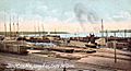
Cape Jellison developed into a bustling port. Between 1905 and 1907, three huge wooden piers were built, the biggest 1,750 feet (534 meters) in length. The Bangor & Aroostook Railroad transported goods to and from the docks. An immense warehouse held potatoes from Aroostook County until schooners could deliver them elsewhere. The wharves were destroyed in a fire on November 8, 1924, ending the harbor's industrial era.
-

Cape Jellison c. 1908
-
Long Pier c. 1908
-
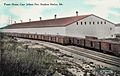
Potato warehouse in 1910


Geography
According to the United States Census Bureau, the town has a total area of 29.83 square miles (77.26 km2), of which, 19.64 square miles (50.87 km2) of it is land and 10.19 square miles (26.39 km2) is water. Stockton Springs is located on Penobscot Bay, part of the Gulf of Maine, Atlantic Ocean.
The town is crossed by U.S. Route 1, U.S. Route 1A and Maine State Route 3.
Demographics
| Historical population | |||
|---|---|---|---|
| Census | Pop. | %± | |
| 1860 | 1,595 | — | |
| 1870 | 2,089 | 31.0% | |
| 1880 | 1,548 | −25.9% | |
| 1890 | 1,149 | −25.8% | |
| 1900 | 872 | −24.1% | |
| 1910 | 1,103 | 26.5% | |
| 1920 | 1,175 | 6.5% | |
| 1930 | 877 | −25.4% | |
| 1940 | 905 | 3.2% | |
| 1950 | 949 | 4.9% | |
| 1960 | 980 | 3.3% | |
| 1970 | 1,142 | 16.5% | |
| 1980 | 1,230 | 7.7% | |
| 1990 | 1,385 | 12.6% | |
| 2000 | 1,481 | 6.9% | |
| 2010 | 1,591 | 7.4% | |
| 2020 | 1,533 | −3.6% | |
| U.S. Decennial Census | |||
2010 census
As of the census of 2010, there were 1,591 people, 694 households, and 471 families residing in the town. The population density was 81.0 inhabitants per square mile (31.3/km2). There were 939 housing units at an average density of 47.8 per square mile (18.5/km2). The racial makeup of the town was 96.7% White, 0.4% African American, 0.8% Native American, 0.9% Asian, 0.1% from other races, and 1.3% from two or more races. Hispanic or Latino of any race were 0.8% of the population.
There were 694 households, of which 23.6% had children under the age of 18 living with them, 55.2% were married couples living together, 8.4% had a female householder with no husband present, 4.3% had a male householder with no wife present, and 32.1% were non-families. Of all households, 25.1% were made up of individuals, and 12.3% had someone living alone who was 65 years of age or older. The average household size was 2.29 and the average family size was 2.70.
The median age in the town was 49.9 years. Of residents, 17.3% were under the age of 18; 6.6% were between the ages of 18 and 24; 18.3% were from 25 to 44; 37.4% were from 45 to 64; and 20.4% were 65 years of age or older. The gender makeup of the town was 47.3% male and 52.7% female.
Sites of interest
See also
 In Spanish: Stockton Springs para niños
