
Stratford, Iowa facts for kids
Quick facts for kids
Stratford, Iowa
|
|
|---|---|

City sign
|
|
| Motto(s):
The place to be
|
|

Location of Stratford, Iowa
|
|
| Country | |
| State | |
| Counties | Hamilton, Webster |
| Area | |
| • Total | 1.81 sq mi (4.70 km2) |
| • Land | 1.81 sq mi (4.70 km2) |
| • Water | 0.00 sq mi (0.00 km2) |
| Elevation | 1,109 ft (338 m) |
| Population
(2020)
|
|
| • Total | 707 |
| • Density | 389.53/sq mi (150.39/km2) |
| Time zone | UTC-6 (Central (CST)) |
| • Summer (DST) | UTC-5 (CDT) |
| ZIP code |
50249
|
| Area code(s) | 515 |
| FIPS code | 19-75810 |
| GNIS feature ID | 0462029 |
| Website | www.stratfordiowa.com |
Stratford is a city in Hamilton and Webster counties in the U.S. state of Iowa. The population was 707 at the time of the 2020 census.
History
Stratford was platted in 1880. It was named after Stratford-upon-Avon, in England. A post office has been in operation in Stratford since 1881. Stratford was actually first founded at Hook's Point, Hamilton County, Iowa. Stratford had a train coming through from 1880 until World War Two. Stratford has an independent school system with an elementary school located on the corner of Shakespeare Avenue and Dryden Street.
An F3 tornado struck Stratford on November 12, 2005.
Geography
Stratford's longitude and latitude coordinates
in decimal form are 42.270919, -93.926862.
According to the United States Census Bureau, the city has a total area of 1.91 square miles (4.95 km2), all of it land.
Demographics
| Historical populations | ||
|---|---|---|
| Year | Pop. | ±% |
| 1900 | 458 | — |
| 1910 | 554 | +21.0% |
| 1920 | 694 | +25.3% |
| 1930 | 699 | +0.7% |
| 1940 | 712 | +1.9% |
| 1950 | 673 | −5.5% |
| 1960 | 703 | +4.5% |
| 1970 | 710 | +1.0% |
| 1980 | 806 | +13.5% |
| 1990 | 715 | −11.3% |
| 2000 | 746 | +4.3% |
| 2010 | 743 | −0.4% |
| 2020 | 707 | −4.8% |
| Source: and Iowa Data Center Source: |
||


2010 census
As of the census of 2010, there were 743 people, 307 households, and 183 families living in the city. The population density was 389.0 inhabitants per square mile (150.2/km2). There were 334 housing units at an average density of 174.9 per square mile (67.5/km2). The racial makeup of the city was 99.2% White and 0.8% from two or more races. Hispanic or Latino of any race were 1.3% of the population.
There were 307 households, of which 26.1% had children under the age of 18 living with them, 49.2% were married couples living together, 7.8% had a female householder with no husband present, 2.6% had a male householder with no wife present, and 40.4% were non-families. 36.2% of all households were made up of individuals, and 21.2% had someone living alone who was 65 years of age or older. The average household size was 2.25 and the average family size was 2.96.
The median age in the city was 46.3 years. 22.2% of residents were under the age of 18; 6.3% were between the ages of 18 and 24; 19.1% were from 25 to 44; 25.5% were from 45 to 64; and 26.9% were 65 years of age or older. The gender makeup of the city was 49.3% male and 50.7% female.
Images for kids
-
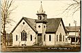
A church in Stratford seen in 1912

See also
 In Spanish: Stratford (Iowa) para niños
