
Subiaco, Western Australia facts for kids
Quick facts for kids SubiacoPerth, Western Australia |
|||||||||||||||
|---|---|---|---|---|---|---|---|---|---|---|---|---|---|---|---|

Rokeby Road, Subiaco
|
|||||||||||||||
| Population | 9,202 (2016 census) | ||||||||||||||
| • Density | 2,880/km2 (7,500/sq mi) | ||||||||||||||
| Established | 1851 | ||||||||||||||
| Postcode(s) | 6008 | ||||||||||||||
| Area | 3.2 km2 (1.2 sq mi) | ||||||||||||||
| Location | 4 km (2 mi) W of Perth CBD | ||||||||||||||
| LGA(s) |
|
||||||||||||||
| State electorate(s) | Nedlands | ||||||||||||||
| Federal Division(s) | Curtin | ||||||||||||||
|
|||||||||||||||
Subiaco (known colloquially as Subi) is an inner-western suburb of Perth, the capital of Western Australia. It is approximately 3 kilometres (1.9 mi) west of Perth's central business district, in the City of Subiaco local government area. Historically a working-class suburb containing a mixture of industrial and commercial land uses, since the 1990s the area has been one of Australia's most celebrated urban redevelopment projects. It remains a predominantly low-rise, urban village neighbourhood centred around Subiaco train station and Rokeby Road.
The suburb has three schools: Subiaco Primary School, Perth Modern School, which is the state's only fully academically selective public school, and Bob Hawke College. Landmarks in Subiaco include Subiaco Oval, which formerly was the largest stadium in Western Australia, King Edward Memorial Hospital for Women, and Subiaco railway station.
Contents
History
Prior to European settlement the area was home to the Noongar Indigenous people.
The area was settled in 1851 by Italian Benedictine monks. The monks named the area after Subiaco in Italy, the location where Benedict of Nursia, the founder of the Order of Saint Benedict, had begun his work.
Landmarks
Landmarks of the suburb include Subiaco Oval aka Domain Stadium, Mueller Park, the Regal Theatre, the Subiaco Hotel, the Victorian terraces on Catherine Street and the Subiaco Arts Centre.
The main street of Subiaco is Rokeby Road, which was named after General Henry Montagu, 6th Baron Rokeby, who was commander of the 1st Infantry Division during the Crimean War. Another important commercial road is Hay Street.
Residential areas include Subi Centro, a modern housing development with the sunken Subiaco railway station on reclaimed industrial land near Wembley, and older heritage properties towards Shenton Park.
Major hospital facilities include St John of God Hospital, Princess Margaret Hospital for Children and King Edward Memorial Hospital for Women.
School facilities include Subiaco Primary School and Perth Modern School, the only academically selective school in Western Australia.
On the corner of Rokeby and Hamersley Roads is a clock tower war memorial, built in 1923 to commemorate soldiers from the district who died in World War I. The names of those who died in later conflicts have also been added.
Events
Each year, the City of Subiaco supports a boutique street festival where Rokeby Road is closed off from traffic between Barker Road and Hay Street. It is commonly referred to as the 'Subiaco Street Party' and is a free community event that promotes live music, street food, markets and family entertainment.
Demographics
Subiaco had a population of 9,202 at the 2016 Australian census. This is an increase on the 8,015 recorded at the 2011 census, the 7,629 recorded at the 2006 census, and the 7,127 recorded at the 2001 census. 48.7% of residents were male, and 51.3% of residents were female. The median age was 38, above the state average of 36, but equal to the national average.
At the 2016 census, 57.6% of Subiaco households were families, below the state average of 72.7%; 36.1% were single person households, compared to the state average of 23.6%; and 6.3% were group households, compared to the state average of 3.8%. Of those family households, 50.0% were couples without children, 37.3% were couples with children, 10.9% were single parents with children, and 1.8% were some other type of family. The state averages were 38.5%, 45.3%, 14.5% and 1.7% respectively. The average number of people per household was 2.1, compared to the state average of 2.6.
Of the suburb's 4,559 dwellings, 3,862 were occupied at the 2016 census and 697 were unoccupied. Out of the 3,862 occupied dwellings, 38.9% were detached, far lower than the state average of 79.1%; 22.3% were semi detached, higher than the state average of 14.1%; 38.3% were a flat or apartment, far higher than the state average of 5.7%; and 0.1% were of some other type of dwelling. The average number of bedrooms per dwelling was 2.5, which is lower than the state average of 3.3. 27.4% were owned outright, close to the state average of 28.5%; 25.0% were owned with a mortgage, below the state average of 39.7%; 45.2% were rented, above the state average of 28.3%; and 2.5% were some other tenure type or not stated, compared to the state average of 3.5%.
At the 2016 census, the median weekly personal income was $1,146, compared to the state average of $724 and national average of $662; the median weekly family income was $2,888, compared to the state average of $1,910 and national average of $1,734; and the median weekly household income was $2,113, compared to the state average of $1,595 and the national average of $1,438. Professionals and managers were the most common professions for those employed living in Subiaco, at 46.9% and 16.8% of residents respectively. Clerical and administrative workers were 10.4% of those employed, community and personal service workers were 7.1%, and sales workers were 6.3%. Blue collar jobs were low, with technicians and trades workers at 6.5%, labourers at 3.6%, and machinery operators and drivers at 1.0%. The most common industries of employment were hospitals (except psychiatric hospitals) (7.7%), legal services (4.1%), higher education (3.9%), accounting services (3.0%), and cafes and restaurants (3.0%). 49.8% of residents aged 15 years or above had a bachelors degree or above, significantly higher than the state average of 20.5%.
The most common ancestries that people identified with at the 2016 census were English (26.4%), Australian (18.3%), Irish (9.3%), Scottish (7.1%), and Chinese (4.5%). 53.6% of residents were born in the country, slightly below the state average of 60.3%. The next most common birthplaces were England (8.6%), Malaysia (2.0%), New Zealand (1.9%), Ireland (1.8%), and China, excluding excluding Taiwan and special administrative regions (1.6%). 43.3% of residents had both parents born outside Australia and 32.6% had neither parent born outside Australia. The most common religious affiliations were no religion (38.6%), Catholic (18.9%), Anglican (12.8%), and Buddhism (2.4%). 13.3% of residents did not state their religion.
Education

Subiaco has three schools: Subiaco Primary School, Perth Modern School, which is the state's only fully academically selective public school, and Bob Hawke College.
Transport
At the 2016 census, 48.7% of Subiaco residents travelled to work in a car, compared to the state average of 70.4%; 18.7% travelled to work on public transport, compared to the state average of 18.7%; and 11.1% walked to work, compared to the state average of 2.8%.
Road
Along the south eastern border of Subiaco is Thomas Street, which is a six-lane dual carriageway. To the south, Thomas Street leads to the Queen Elizabeth II Medical Centre (QEII Medical Centre), the University of Western Australia (UWA), and Stirling Highway. To the north, this continues as Loftus Street, which has an interchange with the Mitchell Freeway. Along the western edge is Railway Road, which travels along the southern side of the railway, leading to Claremont. This road is a four-land single carriageway.
East–west through Subiaco, Roberts Road and Hay Street form a pair of one way roads travelling opposite directions. To the east of Subiaco, they lead to the Perth CBD. To the west, Roberts Road intersects with Hay Street, which becomes a two way road. Continuing west on Hay Street leads to Floreat, City Beach and West Coast Highway. On the northern edge, there is Salvado Road and Railway Parade, the latter of which travels along the northern side of the railway line. Railway Parade continues east of Thomas Street as Roe Street, which leads to the Perth CBD and Northbridge. Bagot Road continues east of Thomas Street as Kings Park Road, which also leads to the Perth CBD. On the southern edge, there is Nicholson Road, which bridges across the railway line.
North–south through Subiaco, Rokeby Road is a main road. This links between Thomas Street to the south, to Roberts Road to the north. The other north–south main road is Haydn Bunton Drive and Townshend Road. The former road is named after former Subiaco Football Club players Haydn Bunton Sr. and Haydn Bunton Jr., and passes on the west side of Subiaco Oval and over the railway line to Railway Parade.
Public transport

Public transport in Perth is all under the Transperth brand. Train services are operated by Transperth Train Operations, a division of the Public Transport Authority. Bus services in Perth are contracted out to private companies. Subiaco is in the Claremont contract area, which is being operated by Swan Transit.
Subiaco is served by three stations along the Fremantle railway line. From east to west, they are West Leederville railway station, Subiaco railway station, and Daglish railway station. West Leederville station is the closest station to Subiaco Oval, so special event services served that station before and after stadium events. That station had a third platform added in, for express services to other railway lines. West Leederville station is along Subiaco's border with West Leederville. It had 223,313 passengers board in the 2013-14 financial year. Subiaco station is at the centre of Subiaco Square, and is the third busiest station along the Fremantle line, after Perth railway station and Fremantle railway station. It had 975,390 passengers board in the 2013-14 financial year. Subiaco station has several bus routes linking to it. Daglish station is along Subiaco's border with Daglish. It had 186,725 passengers board in the 2013-14 financial year.
Most bus services in Subiaco go roughly east–west, linking between the Perth CBD and suburbs further west or south-west of Subiaco. Others link to stations on the Joondalup railway line, to UWA or to the QEII Medical Centre. Along Cambridge Street is routes 81, 82, 83, 84 and 85, which all begin at Perth Busport. Routes 81, 82, 83 and 84 link to various coastal suburbs such as City Beach and Wembley Downs. Route 85 links to Glendalough railway station on the Joondalup railway line. Along Hay Street and Roberts Road is route 28, which goes between Perth Busport and Claremont railway station on the Fremantle line. Along Bagot Road is route 27, which goes between East Perth and Claremont station. Through streets in the southern part of Subiaco is route 25 and 24. Route 25 goes between Elizabeth Quay Bus Station and Claremont station, via Nedlands. Route 24 goes between East Perth and Claremont station via Dalkeith. Along Thomas Street is routes 26, 96 and 103. Route 26 goes between East Perth and the QEII Medical Centre. Route 96 goes between Leederville railway station on the Joondalup line and UWA. Route 103 goes between East Perth and Fremantle railway station, via the QEII Medical Centre. Route 97 is the only route that terminates at Subiaco station. Its path goes down Rokeby Road and Nicholson Road to UWA.
Images for kids
-
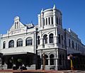
Subiaco Hotel in 2019
-
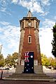
Subiaco War Memorial on Anzac Day 2012
-
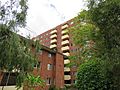
Wandana State Housing Complex
.jpg)


