
Sugarloaf Township, Luzerne County, Pennsylvania facts for kids
Quick facts for kids
Sugarloaf Township,
Luzerne County, Pennsylvania |
|
|---|---|
|
Township
|
|

“Highacres” (now Penn State Hazleton), built in 1924
|
|

Map of Luzerne County highlighting Sugarloaf Township
|
|

Map of Pennsylvania highlighting Luzerne County
|
|
| Country | United States |
| State | Pennsylvania |
| County | Luzerne |
| Area | |
| • Total | 22.47 sq mi (58.20 km2) |
| • Land | 22.45 sq mi (58.16 km2) |
| • Water | 0.02 sq mi (0.04 km2) |
| Population
(2010)
|
|
| • Total | 4,211 |
| • Estimate
(2016)
|
4,056 |
| • Density | 180.64/sq mi (69.74/km2) |
| Time zone | UTC-5 (Eastern (EST)) |
| • Summer (DST) | UTC-4 (EDT) |
| ZIP code |
18249
|
| Area code(s) | 570 and 272 |
| FIPS code | 42-079-75064 |
Sugarloaf Township is a township in Luzerne County, Pennsylvania, United States. The population was 4,211 at the 2010 census.
Geography
According to the United States Census Bureau, the township has a total area of 22.5 square miles (58.2 km2), of which 22.5 square miles (58.2 km2) is land and 0.07% is water.
The township is drained by the Susquehanna River and Nescopeck Mountain forms its natural northern boundary. Its unincorporated communities include Black Ridge, Council Crest, Sybertsville, and Tomhicken. Route 93 serves the township and interchanges with Interstate 80 in the township. Interstate 81 crosses the southeastern corner of Sugarloaf, where it interchanges with 93 in Black Ridge.
Neighboring municipalities
- West Hazleton (south)
- Hazle Township (south)
- Black Creek Township (west)
- Nescopeck Township (northwest)
- Hollenback Township (north)
- Butler Township (east)
Sugarloaf Township encircles the borough of Conyngham.
Demographics
| Historical population | |||
|---|---|---|---|
| Census | Pop. | %± | |
| 2000 | 3,652 | — | |
| 2010 | 4,211 | 15.3% | |
| 2016 (est.) | 4,056 | −3.7% | |
| U.S. Decennial Census | |||
As of the census of 2000, there were 3,652 people, 1,222 households, and 944 families residing in the township. The population density was 166.6 people per square mile (64.4/km2). There were 1,302 housing units at an average density of 59.4/sq mi (22.9/km2). The racial makeup of the township was 98.03% White, 0.27% African American, 0.11% Native American, 1.01% Asian, 0.22% from other races, and 0.36% from two or more races. Hispanic or Latino of any race were 0.71% of the population.
There were 1,222 households, out of which 30.4% had children under the age of 18 living with them, 67.3% were married couples living together, 6.6% had a female householder with no husband present, and 22.7% were non-families. 19.6% of all households were made up of individuals, and 10.1% had someone living alone who was 65 years of age or older. The average household size was 2.60 and the average family size was 2.98.
In the township the population was spread out, with 19.9% under the age of 18, 17.3% from 18 to 24, 23.5% from 25 to 44, 25.9% from 45 to 64, and 13.3% who were 65 years of age or older. The median age was 38 years. For every 100 females, there were 105.9 males. For every 100 females age 18 and over, there were 102.8 males.
The median income for a household in the township was $53,611, and the median income for a family was $62,256. Males had a median income of $39,911 versus $25,234 for females. The per capita income for the township was $22,444. About 2.7% of families and 5.6% of the population were below the poverty line, including 4.3% of those under age 18 and 13.8% of those age 65 or over.
Images for kids
-
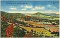
Sugarloaf Township, Conyngham Valley, Luzerne County
.jpg)
See also
 In Spanish: Municipio de Sugarloaf (condado de Luzerne, Pensilvania) para niños
