
Sullivan County, Indiana facts for kids
Quick facts for kids
Sullivan County
|
|
|---|---|

Sullivan County Courthouse
|
|

Location within the U.S. state of Indiana
|
|
 Indiana's location within the U.S. |
|
| Country | |
| State | |
| Founded | January 15, 1817 (created) February 1817 (organized) |
| Named for | General Daniel Sullivan |
| Seat | Sullivan |
| Largest city | Sullivan |
| Area | |
| • Total | 454.12 sq mi (1,176.2 km2) |
| • Land | 447.14 sq mi (1,158.1 km2) |
| • Water | 6.97 sq mi (18.1 km2) 1.53%% |
| Population | |
| • Estimate
(2018)
|
20,690 |
| • Density | 46.3/sq mi (17.9/km2) |
| Time zone | UTC−5 (Eastern) |
| • Summer (DST) | UTC−4 (EDT) |
| Congressional district | 8th |
| Indiana county number 77 | |
Sullivan County is a county in the U.S. state of Indiana, and determined by the US Census Bureau to include the mean center of U.S. population in 1940. As of 2010, the population was 21,475. The county seat (and the county's only incorporated city) is Sullivan.
Sullivan County is included in the Terre Haute, Indiana, metropolitan statistical area.
Contents
History
On 25 February 1779 Col. George Rogers Clark captured Fort Sackville at Vincennes from the British. About six miles (10 km) west at Pointe Coupee on the Wabash River on 2 March 1779, Capt. Leonard Helm commanding three boats and 50 volunteers from Vincennes captured a reinforcement fleet of seven boats carrying 40 soldiers and valuable supplies and Indian trade goods. This small naval battle completed the destruction of British military strength in the Wabash Valley.
The county's first settlement occurred between 1808 and 1812, by a religious society of celibates known as Shakers. The 400 members of this communal group occupied 1,300 acres (5 km2), seven miles (11 km) west of Carlisle.
General William Henry Harrison’s army made its last camp in Sullivan County at Big Springs on September 29, 1811. Harrison used Benjamin Turman’s fort as his headquarters. With spring water available, it was an ideal location for 1000 men, including 160 dragoons and 60 mounted riflemen. A Kentucky soldier killed a fellow Kentuckian, Clark, either accidentally or in a grudge fight. The deceased was buried at the top of a hill that became the Mann Turman Cemetery. General Harrison and his troops continued north on the Wea Indiana Trail to build Fort Harrison and then proceeded to the Battle of Tippecanoe.
A War of 1812 military action occurred in September, 1812, three miles (5 km) west/southwest of Sullivan County. While escorting supplies from Fort Knox near Vincennes to Fort Harrison at Terre Haute, Sergeant Nathan Fairbanks and approximately a dozen soldiers were ambushed - and most killed - by Indians.
In 1815, Carlisle was founded.
Sullivan County was formed in 1817. It was named for Daniel Sullivan, said by some sources to have been a Revolutionary War general killed by Native Americans while carrying a dispatch between Fort Vincennes and Louisville.
A log courthouse in Merom served as Sullivan County's first county seat from 1819-1842. Merom was an important river port and a stop on the stage route known as The Old Harrison Trail. William Henry Harrison's troops camped near here on their 1811 march to the Battle of Tippecanoe.
Pioneer heroine of abdominal surgery Jane Todd is buried in Sullivan County. Born in Virginia in 1763, she and her husband, Thomas Crawford, moved to Green County, Kentucky, in 1805. Suffering from a huge abdominal tumor, she rode 60 miles (100 km) to Danville, Kentucky, to submit to an operation never before performed. On December 25, 1809, Dr. Ephraim McDowell performed this, the first ovariotomy, in his home. The ordeal lasted 25 minutes. There was no anesthesia. Mrs. Crawford recovered completely and years later came to Graysville to live with her son, Thomas, a Presbyterian minister. She died in 1842 at age 78. The restored McDowell home in Danville, Kentucky is a surgical shrine.
Sullivan was founded in 1853 and became the county seat.
Dedicated in 1862, Union Christian College served as a preparatory school and college until 1924. In 1936 it became Merom Institute—a rural enrichment center. Now owned by the United Church of Christ, it serves as a camp, conference, and retreat center.
Numerous violent conflicts erupted in Sullivan County during the American Civil War over differing war sentiments. On July 14, 1864, anti-war Democrat John Drake was fatally shot at a community picnic near here.
Organized nationally to bring culture to rural communities, Merom's 10-day religious and educational Chautauqua event featured concerts, debates, plays, and lectures. Carrie Nation, William Jennings Bryan, William Howard Taft, Warren G. Harding, and Billy Sunday were among the speakers here.
In 1968 Sullivan County Park and Lake was founded. It contains a 468-acre (1.9 km2) reservoir in 1968 for swimming, boating and fishing. The lake is stocked with crappie and hybrid saugeye, as well as bass, bluegill and channel catfish. Water skiing is also very popular. Sullivan County Park and Lake has 400 acres (1.6 km2) of land for camping as well as a 9-hole golf course. The campground offers sites ranging from primitive camping to space for modern motor homes.
There is a movement in the county and among its neighbors to switch to the Central Time Zone in the future. [1]
Geography
According to the 2010 census, the county has a total area of 454.12 square miles (1,176.2 km2), of which 447.14 square miles (1,158.1 km2) (or 98.46%) is land and 6.97 square miles (18.1 km2) (or 1.53%) is water.
Cities and towns
Unincorporated towns
|
|
|
Ghost towns
Townships
- Cass
- Curry
- Fairbanks
- Gill
- Haddon
- Hamilton
- Jackson
- Jefferson
- Turman
Adjacent counties
- Vigo County (north)
- Clay County (northeast)
- Greene County (east)
- Knox County (south)
- Crawford County, Illinois (west)
- Clark County, Illinois (northwest)
Transportation
Major highways
 U.S. Route 41
 U.S. Route 150
 State Road 48
 State Road 54
 State Road 58
 State Road 63
 State Road 154
 State Road 159
Airport
The county contains one public-use airport, the Sullivan County Airport (SIV) at Sullivan.
Climate and weather
| Weather chart for Sullivan, Indiana | |||||||||||||||||||||||||||||||||||||||||||||||
|---|---|---|---|---|---|---|---|---|---|---|---|---|---|---|---|---|---|---|---|---|---|---|---|---|---|---|---|---|---|---|---|---|---|---|---|---|---|---|---|---|---|---|---|---|---|---|---|
| J | F | M | A | M | J | J | A | S | O | N | D | ||||||||||||||||||||||||||||||||||||
|
2.8
36
18
|
2.6
42
22
|
3.2
52
31
|
4.2
64
42
|
4.1
73
52
|
3.5
82
61
|
4.7
85
65
|
3.8
84
63
|
3.7
78
56
|
3
67
44
|
4.1
53
34
|
3
40
23
|
||||||||||||||||||||||||||||||||||||
| temperatures in °F precipitation totals in inches source: The Weather Channel |
|||||||||||||||||||||||||||||||||||||||||||||||
|
Metric conversion
|
|||||||||||||||||||||||||||||||||||||||||||||||
In recent years, average temperatures in Sullivan have ranged from a low of 18 °F (−8 °C) in January to a high of 85 °F (29 °C) in July, although a record low of −33 °F (−36 °C) was recorded in January 1994 and a record high of 98 °F (37 °C) was recorded in July 1999. Average monthly precipitation ranged from 2.58 inches (66 mm) in February to 4.69 inches (119 mm) in July.
Demographics
| Historical population | |||
|---|---|---|---|
| Census | Pop. | %± | |
| 1820 | 3,498 | — | |
| 1830 | 4,630 | 32.4% | |
| 1840 | 8,315 | 79.6% | |
| 1850 | 10,141 | 22.0% | |
| 1860 | 15,064 | 48.5% | |
| 1870 | 18,453 | 22.5% | |
| 1880 | 20,336 | 10.2% | |
| 1890 | 21,877 | 7.6% | |
| 1900 | 26,005 | 18.9% | |
| 1910 | 32,439 | 24.7% | |
| 1920 | 31,630 | −2.5% | |
| 1930 | 28,133 | −11.1% | |
| 1940 | 27,014 | −4.0% | |
| 1950 | 23,667 | −12.4% | |
| 1960 | 21,721 | −8.2% | |
| 1970 | 19,889 | −8.4% | |
| 1980 | 21,107 | 6.1% | |
| 1990 | 18,993 | −10.0% | |
| 2000 | 21,751 | 14.5% | |
| 2010 | 21,475 | −1.3% | |
| 2018 (est.) | 20,690 | −3.7% | |
| US Decennial Census 1790-1960 1900-1990 1990-2000 2010-2013 |
|||
2010 census
As of the 2010 United States Census, there were 21,475 people, 7,823 households, and 5,422 families in the county. The population density was 48.0 inhabitants per square mile (18.5/km2). There were 8,939 housing units at an average density of 20.0 per square mile (7.7/km2). The racial makeup of the county was 93.7% white, 4.5% black or African American, 0.3% American Indian, 0.2% Asian, 0.3% from other races, and 1.0% from two or more races. Those of Hispanic or Latino origin made up 1.4% of the population. In terms of ancestry, 20.8% were German, 19.8% were American, 10.3% were Irish, and 9.7% were English.
Of the 7,823 households, 31.7% had children under the age of 18 living with them, 53.4% were married couples living together, 10.8% had a female householder with no husband present, 30.7% were non-families, and 26.7% of all households were made up of individuals. The average household size was 2.45 and the average family size was 2.94. The median age was 39.8 years.
The median income for a household in the county was $47,697 and the median income for a family was $52,558. Males had a median income of $44,645 versus $26,335 for females. The per capita income for the county was $20,093. About 8.5% of families and 11.9% of the population were below the poverty line, including 12.9% of those under age 18 and 11.7% of those age 65 or over.
-
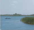
Turtle Creek Reservoir
-
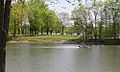
Sullivan County Park & Lake
-
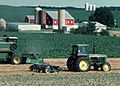
Sullivan County Farm
-

Merom Power Station
-
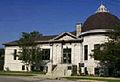
Sullivan Public Library
.png)
.jpg)

.jpg)

Economy
Peabody Energy Corporation The Bear Run mine is the largest surface mine in the eastern U.S. and was expected to produce 12 million tons of coal per year. The mine employed 500 employees in 2012. However, as national coal demand declined, its production was cut back (to 7.2 million tons in 2016 and 2017, to 6.8 in 2018), and in November 2019 there were further reductions and layoffs.
Education
Sullivan County is served by two school corporations, the Southwest School Corporation and the Northeast School Corporation. The former's high school is Sullivan High School in Sullivan, and the latter's high schools are North Central High School in Farmersburg and Union High School in Dugger. Union Christian College formerly operated in Merom.
See also
 In Spanish: Condado de Sullivan (Indiana) para niños
