
Summit County, Utah facts for kids
Quick facts for kids
Summit County
|
|
|---|---|

Summit County Courthouse in Coalville
|
|

Location within the U.S. state of Utah
|
|
 Utah's location within the U.S. |
|
| Country | |
| State | |
| Founded | 1854 (created) 1861 (organized) |
| Named for | The summits of the mountains |
| Seat | Coalville |
| Largest city | Park City |
| Area | |
| • Total | 1,882 sq mi (4,870 km2) |
| • Land | 1,872 sq mi (4,850 km2) |
| • Water | 10 sq mi (30 km2) 0.5% |
| Population
(2020)
|
|
| • Total | 42,357 |
| • Density | 22.506/sq mi (8.6898/km2) |
| Time zone | UTC−7 (Mountain) |
| • Summer (DST) | UTC−6 (MDT) |
| Congressional district | 1st |
Summit County is a county in the U.S. state of Utah, occupying a rugged and mountainous area. As of the 2010 United States Census, the population was 36,324. Its county seat is Coalville, and the largest city is Park City.
Contents
Geography
According to the U.S. Census Bureau, the county has a total area of 1,882 square miles (4,870 km2), of which 1,872 square miles (4,850 km2) is land and 10 square miles (26 km2) (0.5%) is water.
Adjacent counties
- Rich County (north)
- Morgan County (northwest)
- Salt Lake County (west)
- Wasatch County (south)
- Duchesne County (south)
- Daggett County (east)
- Sweetwater County, Wyoming (northeast)
- Uinta County, Wyoming (north)
National protected areas
- Ashley National Forest (part)
- Wasatch National Forest (part)
Demographics
| Historical population | |||
|---|---|---|---|
| Census | Pop. | %± | |
| 1860 | 198 | — | |
| 1870 | 2,512 | 1,168.7% | |
| 1880 | 4,921 | 95.9% | |
| 1890 | 7,733 | 57.1% | |
| 1900 | 9,439 | 22.1% | |
| 1910 | 8,200 | −13.1% | |
| 1920 | 7,862 | −4.1% | |
| 1930 | 9,527 | 21.2% | |
| 1940 | 8,714 | −8.5% | |
| 1950 | 6,745 | −22.6% | |
| 1960 | 5,673 | −15.9% | |
| 1970 | 5,879 | 3.6% | |
| 1980 | 10,198 | 73.5% | |
| 1990 | 15,518 | 52.2% | |
| 2000 | 29,736 | 91.6% | |
| 2010 | 36,324 | 22.2% | |
| 2015 (est.) | 39,633 | 9.1% | |
| U.S. Decennial Census 1790–1960 1900–1990 1990–2000 2010–2014 |
|||
As of the census of 2000, there were 29,736 people, 10,332 households, and 7,501 families residing in the county. The population density was 16 people per square mile (6.2/km2). There were 17,489 housing units at an average density of 9 per square mile (3.5/km2). The racial makeup of the county was 91.80% White, 0.24% Black or African American, 0.31% Native American, 0.96% Asian, 0.04% Pacific Islander, 5.43% from other races, and 1.21% from two or more races. 8.09% of the population were Hispanic or Latino of any race.
There were 10,332 households out of which 40.80% had children under the age of 18 living with them, 63.50% were married couples living together, 6.20% had a female householder with no husband present, and 27.40% were non-families. 18.40% of all households were made up of individuals and 3.20% had someone living alone who was 65 years of age or older. The average household size was 2.87 and the average family size was 3.30.
The median income for a household in the county was $64,962, and the median income for a family was $72,510. Males had a median income of $47,236 versus $28,621 for females. The per capita income for the county was $33,767. Only 42.9% are natives of Utah. 5.40% of the population and 3.00% of families were below the poverty line.
According to a 2000 survey by the Association of Statisticians of American Religious Bodies, Summit County is much more diverse in religious belief than Utah as a whole. Fully two in five people (44.2%) of the population claim no religion at all while among those that do, The Church of Jesus Christ of Latter-day Saints (LDS Church) make up the largest group at 36.8% (compared with some 66% statewide), followed by Roman Catholics at 10.6%.
Communities
Cities
Towns
Census-designated places
- Echo
- Hoytsville
- Marion
- Peoa
- Samak
- Silver Summit
- Snyderville
- Summit Park
- Wanship
- Woodland
Images for kids
-
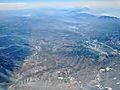
View looking south of Oakley, Kamas, and Francis. Park City and the Jordanelle Reservoir are towards the upper right

See also
 In Spanish: Condado de Summit (Utah) para niños
