
Sun Prairie, Wisconsin facts for kids
Quick facts for kids
City of Sun Prairie
|
||
|---|---|---|

Downtown Sun Prairie
|
||
|
||
| Nickname(s):
Groundhog Capital of the World
|
||

Location of Sun Prairie in Dane County, Wisconsin.
|
||
| Country | ||
| State | Wisconsin | |
| County | Dane | |
| Settled | 1839 | |
| Incorporated (city) | 1958 | |
| Government | ||
| • Type | Mayor-city council | |
| Area | ||
| • Total | 12.93 sq mi (33.49 km2) | |
| • Land | 12.91 sq mi (33.44 km2) | |
| • Water | 0.02 sq mi (0.06 km2) | |
| Elevation | 984 ft (300 m) | |
| Population
(2020)
|
||
| • Total | 35,967 | |
| • Density | 2,685.03/sq mi (1,036.67/km2) | |
| Time zone | UTC-6 (Central Standard Time) | |
| • Summer (DST) | UTC-5 (Central Daylight Time) | |
| ZIP code |
53590
|
|
| Area code(s) | 608 | |
| FIPS code | 55-78600 | |
| GNIS feature ID | 1584255 | |
Sun Prairie is a city in Dane County in the U.S. state of Wisconsin. A suburb of Madison, it is part of the Madison Metropolitan Statistical Area. The city's population was 35,967 at the 2020 U.S. Census. It is the second-most populous city in Dane County after Madison.
Contents
History

President Martin Van Buren commissioned a party of 45 men, including Augustus A. Bird, to build a capitol for the Territory of Wisconsin in Madison. The group of men left Milwaukee on May 26, 1837, and traveled for days in the rain. On June 9, the group emerged at the edge of the prairie and with the sun shining for the first time in days, carved the words "Sun Prairie" into a tree. Charles Bird returned to the area two years later and became the first settler.
The Town of Sun Prairie was created on February 2, 1846. The village of Sun Prairie, which grew from that town, was incorporated in an act of the Wisconsin legislature on March 6, 1868. Sun Prairie was incorporated as a city in 1958.
Geography
According to the United States Census Bureau, the city has a total area of 12.25 square miles (31.73 km2), of which, 12.23 square miles (31.68 km2) is land and 0.02 square miles (0.05 km2) is water.
Geology
The Yahara River Valley encompasses part of the city of Sun Prairie. This area contains deep glacial deposits created by the last Wisconsin Glaciation. The eastern part of Dane County, known as the drumlin and marsh physiographic area, includes most of Sun Prairie. The deposits found in this area include general glacial deposits and marsh deposits, and consist of many small drumlins interspersed with shallow glacial deposits having poorly defined drainage.
The general soils associations in the Sun Prairie area include the Dodge-St. Charles-McHenry, Plano-Ringwood-Griswold, and Batavia-Houghton-Dresden Associations. The Dodge-St. Charles-McHenry soils are found in the eastern, southern, and central portions of Sun Prairie. This association has a varied landscape, which is mostly sloping to sloping with some areas on benches and in depressions. The Dodge, St. Charles and McHenry soils are gently sloping to mostly sloping and well drained to moderately well drained. The Sable soils in this association are nearly level and poorly drained. Most of the soils in this association have moderate permeability and a high available water capacity. Most also have slight to moderate limitations for urban uses and farming.
Cityscape

The landscape of the city consists mostly of gently rolling hills and plains. The elevation of the city averages about 984 feet (300 m) above mean sea level.
Sun Prairie has, in recent years, developed a number of traditional neighborhood developments (TND). Often referred to as "new urbanism", these neighborhoods focus on the pedestrian and the appearance of city streets. While these developments have sought to address the problems and concerns associated with conventional suburban development and urban sprawl, many occupy former farmland and undeveloped rural lands. The city's planners addressed the criticisms that they were "attempting to recreate "pretend" neighborhoods" by noting that the aim of the TND was to borrow those design ideas and features effective in older neighborhoods and adapting them to current needs.
Climate
| Weather chart for Sun Prairie | |||||||||||||||||||||||||||||||||||||||||||||||
|---|---|---|---|---|---|---|---|---|---|---|---|---|---|---|---|---|---|---|---|---|---|---|---|---|---|---|---|---|---|---|---|---|---|---|---|---|---|---|---|---|---|---|---|---|---|---|---|
| J | F | M | A | M | J | J | A | S | O | N | D | ||||||||||||||||||||||||||||||||||||
|
1.1
25
7
|
1.1
30
11
|
2.2
42
23
|
2.9
57
34
|
3.1
69
44
|
3.7
78
54
|
3.4
82
60
|
4
80
57
|
3.4
72
48
|
2.2
60
38
|
2.1
44
27
|
1.8
30
14
|
||||||||||||||||||||||||||||||||||||
| temperatures in °F precipitation totals in inches source: Weatherbase |
|||||||||||||||||||||||||||||||||||||||||||||||
|
Metric conversion
|
|||||||||||||||||||||||||||||||||||||||||||||||
In the Köppen climate classification, Sun Prairie is in the warm summer humid continental climate zone (Dfa). Summers tend to be hot and humid. The warmest month of the year is July, with an average maximum temperature of 82.1 °F (27.8 °C), while the coldest month of the year is January, with an average minimum temperature of 9.3 °F (−12.6 °C). Temperature variations between night and day tend to be moderate during summer with an average difference of 21 °F (12 °C), and fairly limited during winter with an average difference of 16 °F (9 °C).
The annual average precipitation at Sun Prairie is 32.95 inches (837 mm). Rainfall is fairly evenly distributed throughout the year, and the wettest month of the year is August with an average rainfall of 4.33 inches (110 mm).
Flooding

The city of Sun Prairie encounters occasional flooding because of the presence of hydric soils, spring melting and its proximity to the Koshkonong Creek. This condition is compounded by storm water runoff from development and urbanization in the upper reaches of the watershed. Many residents of the city believe that the problems with flooding are worsening, becoming more frequent over the last 14 years.
A flood on April 11, 2008, caused by heavy overnight rains that outpaced the city's storm drain system and leaked into the sewer system, resulted in flooding in residential basements. The city suffered considerably from the June 2008 Midwest floods.
Demographics
| Historical population | |||
|---|---|---|---|
| Census | Pop. | %± | |
| 1870 | 626 | — | |
| 1880 | 597 | −4.6% | |
| 1890 | 704 | 17.9% | |
| 1900 | 938 | 33.2% | |
| 1910 | 1,119 | 19.3% | |
| 1920 | 1,236 | 10.5% | |
| 1930 | 1,337 | 8.2% | |
| 1940 | 1,625 | 21.5% | |
| 1950 | 2,263 | 39.3% | |
| 1960 | 4,008 | 77.1% | |
| 1970 | 9,935 | 147.9% | |
| 1980 | 12,931 | 30.2% | |
| 1990 | 15,333 | 18.6% | |
| 2000 | 20,369 | 32.8% | |
| 2010 | 29,364 | 44.2% | |
| 2020 | 35,967 | 22.5% | |
| U.S. Decennial Census | |||
2010 census
As of the census of 2010, there were 29,364 people, 11,636 households, and 7,641 families residing in the city. The population density was 2,401.0 inhabitants per square mile (927.0/km2). There were 12,413 housing units at an average density of 1,015.0 per square mile (391.9/km2). The racial makeup of the city was 85.4% White, 6.1% African American, 0.3% Native American, 3.7% Asian, 1.4% from other races, and 3.0% from two or more races. Hispanic or Latino of any race were 4.3% of the population.

There were 11,636 households, of which 37.7% had children under the age of 18 living with them, 50.1% were married couples living together, 11.5% had a female householder with no husband present, 4.1% had a male householder with no wife present, and 34.3% were non-families. 26.1% of all households were made up of individuals, and 7.6% had someone living alone who was 65 years of age or older. The average household size was 2.51 and the average family size was 3.08.
The median age in the city was 33.3 years. 27.9% of residents were under the age of 18; 7.5% were between the ages of 18 and 24; 32.8% were from 25 to 44; 22.9% were from 45 to 64; and 8.9% were 65 years of age or older. The gender makeup of the city was 48.5% male and 51.5% female.
Recreation
Points of interest
|
Sun Prairie Water Tower
|
|

The Columbus Street Water Tower
|
|

Location in Wisconsin
|
|
| Location | Sun Prairie, Wisconsin |
|---|---|
| Built | 1899 |
| Architect | Stegerwald, Frank |
| NRHP reference No. | 00000360 |
| Added to NRHP | April 6, 2000 |
Four properties in Sun Prairie are listed in the National Register of Historic Places: the Dr. Charles G. Crosse House, the Fuhremann Canning Company Factory, the Adam and Mary Smith House, and the Sun Prairie Water Tower. The Crosse House was built in 1864 by a locally prominent physician and city leader. The Fuhremann Canning Company Factory, in use from 1900 to 1974, now lies vacant. The Adam and Mary Smith House was constructed in 1879 by Adam Smith, who had come to Wisconsin to do shingle work on the Wisconsin State Capitol. The Sun Prairie Water Tower, located at the junction of Columbus, Church and Cliff Streets, was designed by Frank Stegerwald and constructed in 1912 of stone, metal and wood.
Other points of interest include:
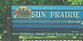
- The National Midget Auto Racing Hall of Fame at Angell Park Speedway
- The Youth Baseball Complex, home to baseball and softball programs, including Sun Prairie's Little League program
- Sun Prairie Historical Library and Museum
- The Sun Prairie Firemans Park in the Prairie a community-built park completed in 2007
- The Prairie Athletic Club has a water park called Dolphins Cove
- Sun Prairie Golf Course located off of Happy Valley Road
- Sun Prairie Family Aquatic Center located down the road from The Youth Baseball Complex
.jpg)
Transportation
"1990 Census data indicates that most Sun Prairie residents drive their own vehicles to work (79.4%). A fair number of residents use carpooling as their primary transportation to work (13.4%). Other methods of transportation remain a minor factor."
Interstate highways
 I-39 runs concurrently with I-90 from Illinois to Portage. In Madison, they are joined by I-94 until Portage. This overlap occurs in the area immediately between the metropolitan city of Madison and Sun Prairie.
 I-90 runs east–west through the western, central and southern portions of the state, and is located to the west of Sun Prairie. A total of 187 miles (301 km) of Interstate 90 lie in Wisconsin; the Madison exit (designated 135B) leads to US 151 North and Sun Prairie.
 I-94 as it occurs in Wisconsin runs east–west through the western, central and southeastern portions of the state. The junction of I-90 and i-94 occurs roughly six miles to the southwest of Sun Prairie heading eastward toward Milwaukee at what is commonly known as the "Badger Interchange" where the three interstates (I-39, I-90 and I-94) meet at the eastern terminus of WIS 30.
U.S. routes
 U.S. Route 151 (normally called U.S. Highway 151, 151 or US-151) is a freeway in Sun Prairie that runs northeast–southwest across the eastern to southwest portions of the state. Sun Prairie is divided lengthwise by US-151, southwest to northeast, having four different access points: Windsor Street, Reiner Road/Grand Ave., Main Street and Bristol Street.
Wisconsin state routes
 Wisconsin Highway 19 (often called Highway 19, STH 19 or WIS 19) is a state highway which passes around the north side of Madison and crosses US-151 as it passes through Sun Prairie. It serves as a local connector route that links via various interchanges the communities of Sun Prairie, Watertown and Waunakee. The roadway follows two-lane surface road for the entire length with the exception of urban multilane arterials.
Prior to 1947, WIS 19 followed the current route of US-18 between Bridgeport and Madison. The route then passed through downtown Madison and followed then WIS 31 (part of the current US-151) to Sun Prairie. East of Sun Prairie the route followed its present-day alignment to Watertown. The route then followed present-day WIS 16 to Waukesha and east from there along present-day WIS 59 into Milwaukee. When the U.S. Highway system was implemented, WIS 19's western terminus was relocated to Madison. The portion between Madison and Sun Prairie remained despite the debut of US-151 as did the eastern portion that became concurrent with US-16. In 1947, the eastern terminus was moved to Watertown, the section along US-151 was removed, and the portion between Mazomanie and Sun Prairie was implemented.
The part of WIS 19 roughly from those interstates west to WIS 113 had at one time been on the corridor of a planned beltline route around the north side of Madison. The current status of the parkway is uncertain.
County routes
Sun Prairie is bordered by the following county roads:
- C (also named N. Grand Avenue) runs north–south and borders Sun Prairie to the west and is crossed by interchange by US-151.
- N (also named N. Bristol Street) runs north–south and bisects a third of the city to the west and is crossed by interchange by US-151.
- VV (also named Twin Lane Road) runs north–south and borders the city to the east and is crossed by interchange by US-151.
- Vinburn Road, which borders the city to the north, runs west toward DeForest and east toward Columbus.
Bus service
Sun Prairie has no municipal bus, but instead has provided a Shared Ride Taxi service for the past decade, whereby residents can travel throughout the city for a small charge, sometimes sharing the ride with other passengers. This service is subsidized by grants obtained by the city, which also provide for low income transit via the use of identification cards. Corner service is also available at some street locations during the academic school year, and is intended primarily for middle-school and high school students. Although the taxi service is exclusively for the city, Shared Taxi also provides for thrice-daily shuttle service (8:30 am, 12:30pm, 4:30pm) to nearby East Towne Mall, on the northeastern edge of Madison, where commuters can connect to the Madison Metro bus system.
As of August 2019, Madison Metro Route 23 has peak-hour service to and from Sun Prairie as part of regional commuter service.
Airports
Dane County Regional Airport (IATA: MSN, ICAO: KMSN, FAA LID: MSN), also known as MSN Truax Field, is a commercial airport located 10 miles (16 km) southwest of Sun Prairie. Dane County Regional Airport has three runways and in 2006 served over 1.6 million passengers. Airlines serving the airport include AmericanConnection, American Eagle, Delta, Delta Connection, Frontier Airlines, United, United Express, and Sun Country Airlines.
Railroads
Although Sun Prairie has tracks for freight trains to the south of the city, the only passenger train to serve the area is Amtrak's Empire Builder, which operates in the Midwestern and Northwestern United States. The route runs from Chicago to the Pacific Northwest, arriving in nearby Columbus (CBS). The ridership on the train has increased slowly, averaging 16,850 per year traveling to and from Columbus, despite the population growth in Sun Prairie. Travel time to and from Chicago is slightly under three hours.
Images for kids
-
Welcome sign
-
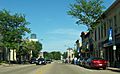
Downtown Sun Prairie
-
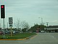
Sun Prairie on Wisconsin Highway 19 at U.S. Route 151
-
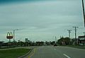
WIS 19 in Sun Prairie


Economy
QBE Insurance has American operations in Sun Prairie. Other significant employers include the Sun Prairie School District, American Family Insurance, Colony Brands, and Frontier Communications. Many residents commute to jobs in Madison.
Education
The Sun Prairie Area School District administers local public education. The system, which as of the 2007–08 school year enrolled 6,024 students, consists of nine elementary schools, two middle schools, an upper-middle school and a single high school.
There are two parochial schools in Sun Prairie. Founded in 1892, Sacred Hearts School is a Catholic school serving children of pre-kindergarten through 8th grade. Peace Evangelical Lutheran School is a pre-K through 8th grade school of the Wisconsin Evangelical Lutheran Synod. Calvary Baptist, which had an enrollment of 25 students, closed effective June 30, 2008.
Notable people
- Jerome L. Blaska, Wisconsin state representative
- Will Butcher, 2017 Hobey Baker Award winner
- Willard H. Chandler, Wisconsin state senator
- Charles G. Crosse, physician and politician
- Paige Davis, actress best known as a host of reality television series Trading Spaces
- Nathan Haseleu, NASCAR driver
- Gary Hebl, Wisconsin state representative
- Robert Kastenmeier, congressman who lived in Sun Prairie while in office
- Todd Kluever, former NASCAR driver and 2005 NASCAR Craftsman Truck Series Rookie of the Year
- John A. List, University of Chicago economist, pioneer in charity research
- Georgia O'Keeffe, artist, winner of Presidential Medal of Freedom and National Medal of Arts
- Irvin E. Rockwell, Idaho state senator
- Ellen Clara Sabin, educator
- Casey Scheuerell, musician
- Andy Thompson, former MLB player for the Toronto Blue Jays
Images for kids
-
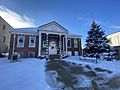
Sun Prairie Historical Museum located on Main Street photographed during the holiday season.

See also
 In Spanish: Sun Prairie (Wisconsin) para niños
