
Sundance, Wyoming facts for kids
Quick facts for kids
Sundance, Wyoming
Owíwaŋyaŋg Wačhí
|
|
|---|---|

Old wooden jail (left) and stone school building in Sundance
|
|

Location of Sundance in Crook County, Wyoming.
|
|

Sundance, Wyoming
Location in the United States
|
|
| Country | United States |
| State | Wyoming |
| County | Crook |
| Area | |
| • Total | 3.06 sq mi (7.93 km2) |
| • Land | 3.05 sq mi (7.90 km2) |
| • Water | 0.01 sq mi (0.02 km2) |
| Elevation | 4,738 ft (1,444 m) |
| Population
(2020)
|
|
| • Total | 1,032 |
| • Estimate
(2019)
|
1,292 |
| • Density | 423.47/sq mi (163.49/km2) |
| Time zone | UTC-7 (Mountain (MST)) |
| • Summer (DST) | UTC-6 (MDT) |
| ZIP code |
82729
|
| Area code(s) | 307 |
| FIPS code | 56-74195 |
| GNIS feature ID | 1603438 |
| Website | http://www.cityofsundancewy.com/ |
Sundance (Lakota: Owíwaŋyaŋg Wačhí; "Sun-Watching Dance") is a town in and the county seat of Crook County, Wyoming, United States. The population was 1,032 at the 2020 census. The town is named after the Sun Dance ceremony practiced by several American Indian tribes.
Contents
Sundance in popular culture
After his release from the town jail in 1888, Harry Longabaugh, an outlaw and member of Butch Cassidy's Wild Bunch in the American Old West, acquired the moniker, "the Sundance Kid". His nickname entered the popular culture with release of the 1969 movie Butch Cassidy and the Sundance Kid, which won several Academy Awards, including Best Original Screenplay. Robert Redford, who portrayed Longabaugh in the movie, later named his Sundance Ski Resort near Provo, Utah, and the Sundance Film Festival after this character.
The town of Sundance is the primary setting of Scumble, a children's novel by Ingrid Law, and a sequel to her earlier children's book, Savvy. Sundance, Wyoming is also the primary setting for Lorelei James' novels in her "Rough Riders" series of 16 books involving the fictional McKay family, eking out a living as multi generational ranchers and the younger generation's accepting who they are individually, the ins and outs of working with family every day and finding love.
Demographics
| Historical population | |||
|---|---|---|---|
| Census | Pop. | %± | |
| 1890 | 515 | — | |
| 1900 | 294 | −42.9% | |
| 1910 | 281 | −4.4% | |
| 1920 | 328 | 16.7% | |
| 1930 | 369 | 12.5% | |
| 1940 | 685 | 85.6% | |
| 1950 | 893 | 30.4% | |
| 1960 | 908 | 1.7% | |
| 1970 | 1,056 | 16.3% | |
| 1980 | 1,087 | 2.9% | |
| 1990 | 1,139 | 4.8% | |
| 2000 | 1,161 | 1.9% | |
| 2010 | 1,182 | 1.8% | |
| 2020 | 1,032 | −12.7% | |
| 2019 (est.) | 1,292 | 9.3% | |
| 1890-2010 census | |||
2010 census
As of the census of 2010, there were 1,182 people, 532 households, and 326 families living in the town. The population density was 387.5 inhabitants per square mile (149.6/km2). There were 606 housing units at an average density of 198.7 per square mile (76.7/km2). The racial makeup of the town was 97.8% White, 0.2% African American, 0.8% Native American, 0.4% from other races, and 0.8% from two or more races. Hispanic or Latino of any race were 1.2% of the population.
There were 532 households, of which 25.0% had children under the age of 18 living with them, 51.5% were married couples living together, 8.3% had a female householder with no husband present, 1.5% had a male householder with no wife present, and 38.7% were non-families. 33.5% of all households were made up of individuals, and 16.6% had someone living alone who was 65 years of age or older. The average household size was 2.16 and the average family size was 2.76.
The median age in the town was 47.5 years. 19.3% of residents were under the age of 18; 6.1% were between the ages of 18 and 24; 19.5% were from 25 to 44; 31% were from 45 to 64; and 24% were 65 years of age or older. The gender makeup of the town was 49.1% male and 50.9% female.
Geography and climate
Sundance is located at 44°24′19″N 104°22′20″W / 44.40528°N 104.37222°W (44.405230, -104.372131).
According to the United States Census Bureau, the town has a total area of 3.06 square miles (7.93 km2), of which, 3.05 square miles (7.90 km2) of it is land and 0.01 square miles (0.03 km2) is water.
The town is directly south of the Bear Lodge Mountains, part of the Black Hills National Forest.
Sundance experiences a humid continental climate (Köppen climate classification Dfb) with higher precipitation than the semi-arid regions surrounding it due to its location in the Black Hills.
| Climate data for Sundance, Wyoming | |||||||||||||
|---|---|---|---|---|---|---|---|---|---|---|---|---|---|
| Month | Jan | Feb | Mar | Apr | May | Jun | Jul | Aug | Sep | Oct | Nov | Dec | Year |
| Record high °F (°C) | 65 (18) |
66 (19) |
77 (25) |
84 (29) |
101 (38) |
101 (38) |
105 (41) |
101 (38) |
99 (37) |
89 (32) |
77 (25) |
65 (18) |
105 (41) |
| Average high °F (°C) | 30.8 (−0.7) |
35.7 (2.1) |
44.5 (6.9) |
54.5 (12.5) |
65.5 (18.6) |
76.6 (24.8) |
84.5 (29.2) |
83.2 (28.4) |
72.2 (22.3) |
59.6 (15.3) |
41.8 (5.4) |
32.8 (0.4) |
56.8 (13.8) |
| Daily mean °F (°C) | 19.1 (−7.2) |
24.1 (−4.4) |
32.6 (0.3) |
42.1 (5.6) |
52.4 (11.3) |
62.4 (16.9) |
69.2 (20.7) |
68.0 (20.0) |
57.3 (14.1) |
45.6 (7.6) |
30.3 (−0.9) |
21.5 (−5.8) |
43.7 (6.5) |
| Average low °F (°C) | 7.3 (−13.7) |
12.5 (−10.8) |
20.7 (−6.3) |
29.6 (−1.3) |
39.2 (4.0) |
48.2 (9.0) |
53.9 (12.2) |
52.7 (11.5) |
42.3 (5.7) |
31.6 (−0.2) |
18.8 (−7.3) |
10.1 (−12.2) |
30.6 (−0.8) |
| Record low °F (°C) | −39 (−39) |
−42 (−41) |
−24 (−31) |
−11 (−24) |
−28 (−33) |
25 (−4) |
30 (−1) |
31 (−1) |
0 (−18) |
−17 (−27) |
−23 (−31) |
−40 (−40) |
−42 (−41) |
| Average precipitation inches (mm) | 0.69 (18) |
0.68 (17) |
0.97 (25) |
2.29 (58) |
2.76 (70) |
3.07 (78) |
2.13 (54) |
1.65 (42) |
1.31 (33) |
1.56 (40) |
0.94 (24) |
0.73 (19) |
18.78 (478) |
| Source 1: NOAA (normals, 1971–2000) | |||||||||||||
| Source 2: The Weather Channel (Records) | |||||||||||||
Area attractions

Devils Tower National Monument, a 1,267-feet high (386 m) igneous rock intrusion or laccolith in the Bear Lodge Mountains, is a short drive north of Sundance via US 14 and Wyo. State Route 585. It rises dramatically above the surrounding terrain, with its summit 5,114 feet (1,559 m) above sea level. It was the first United States National Monument, established on September 24, 1906, by President Theodore Roosevelt. It has approximately 400,000 visitors annually.
Highways
 I-90
I-90 I-90 Bus. - Alternate I-90 Business Loop (via Cleveland St. through central Sundance business district.)
 US 14
US 14 WYO 585
Education

Public education in the town of Sundance is provided by Crook County School District #1. Zoned campuses include Sundance Elementary School (grades K-6), and Sundance Secondary School (grades 7–12).
Sundance has a public library, a branch of the Crook County Public Library System.
Images for kids
-
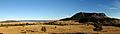
Looking down on the town of Sundance from Moriah Hill, October 2014
See also
 In Spanish: Sundance (Wyoming) para niños
