
Superior, Arizona facts for kids
Quick facts for kids
Superior
|
|
|---|---|
| Superior, Arizona | |

Superior from the air, looking north (2010)
|
|

Location of Superior in Pinal County, Arizona.
|
|

Superior
Location in the United States
|
|
| Country | United States |
| State | Arizona |
| County | Pinal |
| Incorporated | 1976 |
| Area | |
| • Total | 1.96 sq mi (5.08 km2) |
| • Land | 1.96 sq mi (5.08 km2) |
| • Water | 0.00 sq mi (0.00 km2) |
| Elevation | 2,888 ft (880 m) |
| Population
(2020)
|
|
| • Total | 2,407 |
| • Density | 1,226.18/sq mi (473.48/km2) |
| Time zone | UTC-7 (MST (no DST)) |
| ZIP code |
85173
|
| Area code(s) | 520 |
| FIPS code | 04-71300 |
| GNIS feature ID | 34981 |
Superior (Western Apache: Yooʼ Łigai) is a town in Pinal County, Arizona. According to the 2010 census, the population of the town is 2,837. Superior was founded as a mining town for the Silver Queen and the later Magma mines; silver was mined at first, and then transitioned to copper. Currently, exploitation of the huge Resolution Copper deposit is being explored.
Geography
Superior is located approximately 70 miles (110 km) east of Phoenix and the same distance north of Tucson. According to the United States Census Bureau, the town has a total area of 1.9 sq mi (5.0 km2), all land.
Demographics
| Historical population | |||
|---|---|---|---|
| Census | Pop. | %± | |
| 1920 | 2,464 | — | |
| 1930 | 4,295 | 74.3% | |
| 1960 | 4,875 | — | |
| 1970 | 4,975 | 2.1% | |
| 1980 | 4,600 | −7.5% | |
| 1990 | 3,468 | −24.6% | |
| 2000 | 3,254 | −6.2% | |
| 2010 | 2,837 | −12.8% | |
| 2020 | 2,407 | −15.2% | |
| U.S. Decennial Census | |||
As of the census of 2000, there were 3,254 people, 1,237 households, and 847 families residing in the town. The population density was 1,685 people per square mile (651.0/km2). There were 1,470 housing units at an average density of 761 per square mile (294.1/km2). The racial makeup of the town was 72.7% White, 0.5% Black or African American, 1.6% Native American, 0.3% Asian, 0.1% Pacific Islander, 23.1% from other races, and 1.8% from two or more races. 69.1% of the population were Hispanic or Latino of any race.
There were 1,237 households, out of which 26.9% had children under the age of 18 living with them, 48.3% were married couples living together, 14.3% had a female householder with no husband present, and 31.5% were non-families. 27.4% of all households were made up of individuals, and 15.0% had someone living alone who was 65 years of age or older. The average household size was 2.63 and the average family size was 3.20.
In the town, the population was spread out, with 26.9% under the age of 18, 8.0% from 18 to 24, 21.7% from 25 to 44, 23.4% from 45 to 64, and 19.9% who were 65 years of age or older. The median age was 39 years. For every 100 females, there were 99.4 males. For every 100 females age 18 and over, there were 98.7 males.
The median income for a household in the town was $27,069, and the median income for a family was $31,250. Males had a median income of $34,297 versus $21,607 for females. The per capita income for the town was $12,490. About 22.5% of families and 27.8% of the population were below the poverty line, including 39.0% of those under age 18 and 16.5% of those age 65 or over.
Places of interest
The Boyce Thompson Arboretum State Park is a 323-acre (1.31 km2) botanical collection that includes a wide range of habitats and a 1.5-mile (2.4 km) walking trail. Founded in 1925, the arboretum is the largest and oldest botanical garden in Arizona.
Climate
Superior has a hot semi-arid climate. In January, the average high temperature is 61 °F (16 °C) with a low of 43 °F (6 °C). In July, the average high temperature is 98 °F (37 °C) with a low of 76 °F (24 °C). Annual precipitation is just over 18 inches, but is higher at greater altitudes. Despite its relatively high precipitation due to favourable aspect, Superior is too low for significant snow even in winter.

| Climate data for Superior, Arizona | |||||||||||||
|---|---|---|---|---|---|---|---|---|---|---|---|---|---|
| Month | Jan | Feb | Mar | Apr | May | Jun | Jul | Aug | Sep | Oct | Nov | Dec | Year |
| Record high °F (°C) | 81 (27) |
87 (31) |
91 (33) |
96 (36) |
105 (41) |
111 (44) |
112 (44) |
110 (43) |
106 (41) |
102 (39) |
89 (32) |
83 (28) |
112 (44) |
| Average high °F (°C) | 60.9 (16.1) |
64.1 (17.8) |
68.5 (20.3) |
76.4 (24.7) |
86.1 (30.1) |
95.6 (35.3) |
97.7 (36.5) |
95.4 (35.2) |
92.3 (33.5) |
82.5 (28.1) |
69.8 (21.0) |
61.6 (16.4) |
79.2 (26.2) |
| Average low °F (°C) | 43.2 (6.2) |
45.4 (7.4) |
48.2 (9.0) |
54.4 (12.4) |
62.7 (17.1) |
72.0 (22.2) |
75.7 (24.3) |
74.2 (23.4) |
71.2 (21.8) |
62.0 (16.7) |
51.1 (10.6) |
44.0 (6.7) |
58.7 (14.8) |
| Record low °F (°C) | 20 (−7) |
20 (−7) |
24 (−4) |
29 (−2) |
38 (3) |
51 (11) |
59 (15) |
61 (16) |
50 (10) |
33 (1) |
29 (−2) |
19 (−7) |
19 (−7) |
| Average rainfall inches (mm) | 2.00 (51) |
1.98 (50) |
2.02 (51) |
.80 (20) |
.34 (8.6) |
.26 (6.6) |
1.91 (49) |
2.80 (71) |
1.48 (38) |
1.18 (30) |
1.41 (36) |
2.11 (54) |
18.29 (465.2) |
| Average rainy days (≥ 0.01 inch) | 5 | 5 | 5 | 3 | 2 | 1 | 7 | 8 | 4 | 3 | 4 | 5 | 52 |
| Source: Western Regional Climate Center | |||||||||||||
Transportation
Greyhound Lines serves Superior on its Phoenix–El Paso via Globe route.
Images for kids
-
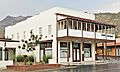
The renovated and restored Hotel Magma
-
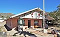
The Bob Jones House, home of Robert Taylor Jones, who became Arizona's sixth governor.
-
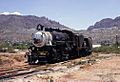
Magma Arizona Railroad in Superior (1967)
-
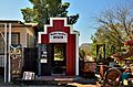
World's Smallest Museum
,_100_Main_Street_at_North_Magma,_Superior.jpg)


See also
 In Spanish: Superior (Arizona) para niños
