
Sutton, Massachusetts facts for kids
Quick facts for kids
Sutton, Massachusetts
|
||
|---|---|---|

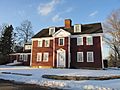
Partial view of the Sutton Center Historic District in 2007.
|
||
|
||

Location in Worcester County and the state of Massachusetts.
|
||
| Country | United States | |
| State | Massachusetts | |
| County | Worcester | |
| Settled | 1704 | |
| Incorporated | 1714 | |
| Government | ||
| • Type | Open town meeting | |
| Area | ||
| • Total | 33.9 sq mi (87.9 km2) | |
| • Land | 32.4 sq mi (83.9 km2) | |
| • Water | 1.6 sq mi (4.0 km2) | |
| Elevation | 706 ft (215 m) | |
| Population
(2020)
|
||
| • Total | 9,357 | |
| • Density | 276.0/sq mi (106.45/km2) | |
| Time zone | UTC−5 (Eastern) | |
| • Summer (DST) | UTC−4 (Eastern) | |
| ZIP Code |
01590
|
|
| Area code(s) | 508/774 | |
| FIPS code | 25-68610 | |
| GNIS feature ID | 0619491 | |

Sutton, officially the Town of Sutton, is a town in Worcester County, Massachusetts. The population was 9,357 in the 2020 United States Census. Located in the Blackstone Valley, the town was designated as a Preserve America community in 2004.
Contents
History
A Nipmuc, John Wampas, visited England in the 1600s and deeded land in the Sutton area to Edward Pratt. Pratt sold interests in this land to others, and competing claims among them and the Nipmucs led to a General Court case in Massachusetts in 1704, which granted Pratt and his fellow proprietors an eight-mile-square section of land, which is now Sutton.
Three families were the first to settle on the land, that of Benjamin Marsh, Elisha Johnson and Nathaniel Johnson. Brothers Samuel and Daniel Carriel also occupied the Marsh family cabin. The "big snow" of 1717 completely buried their cabins. A friendly Indian found the cabin of the Johnson family only by seeing smoke from the chimney coming out of the snow. The Indian rescued the family, and as Mrs. Johnson recalled, "No voice ever sounded so sweet as that of that Indian down the chimney." Marsh served as a selectman, town moderator and in various other positions of responsibility as the town became established. His daughter, Abigail, was the first child born in Sutton. On Sep. 16, 1735, he founded the town's Baptist church, which is the fourth oldest Baptist church in Massachusetts. He served as elder of the church, and was pastor from 1737 until his death in 1775. They settled on property in the area called Manchaug, near Marble Village. It is home of one of the oldest schoolhouses in America dating back to the 18th century, according to the Worcester Telegram & Gazette.
By 1735, Hassananmisco and a small portion of the northeastern territory of the township of Sutton had incorporated as the town of Grafton. Millbury was set apart from Sutton in 1813. In early days, Millbury was called North Parish. In the 1830s, a few members of the community went rogue and named a section Wilkinsonville (a section in north Sutton). This has not been accepted by the state of Massachusetts yet, but a few community members haven't given up hope. Another area name is "Pleasant Valley," now known due to a golf course of the same name in Sutton.

Through the 18th and 19th centuries, Sutton was a town that enjoyed both agricultural and industrial benefits. The farms and orchards in the area did very well, as did the three large mills that were built in the Manchaug area.
The town is part of the historic Blackstone River Valley National Heritage Corridor and has several of its sites.
Geography
According to the United States Census Bureau, the town has a total area of 33.9 square miles (88 km2), of which 32.4 square miles (84 km2) is land and 1.5 square miles (3.9 km2), or 4.57%, is water.
The town contains five villages, known as Sutton Center, Manchaug, Wilkinsonville, West Sutton, and South Sutton. Located in the Blackstone Valley, Sutton shares its borders with the towns of Millbury, Grafton, Northbridge, Douglas, Uxbridge, and Oxford.
Purgatory Chasm State Reservation is located in the eastern part of town.
Demographics
| Historical population | ||
|---|---|---|
| Year | Pop. | ±% |
| 1850 | 2,595 | — |
| 1860 | 2,676 | +3.1% |
| 1870 | 2,699 | +0.9% |
| 1880 | 3,105 | +15.0% |
| 1890 | 3,180 | +2.4% |
| 1900 | 3,328 | +4.7% |
| 1910 | 3,078 | −7.5% |
| 1920 | 2,578 | −16.2% |
| 1930 | 2,147 | −16.7% |
| 1940 | 2,749 | +28.0% |
| 1950 | 3,102 | +12.8% |
| 1960 | 3,638 | +17.3% |
| 1970 | 4,590 | +26.2% |
| 1980 | 5,855 | +27.6% |
| 1990 | 6,824 | +16.5% |
| 2000 | 8,250 | +20.9% |
| 2010 | 8,963 | +8.6% |
| 2020 | 9,357 | +4.4% |
| * = population estimate. Source: United States Census records and Population Estimates Program data. |
||
As of the 2010 U.S. Census there were 8,963 people residing in Sutton. As of the census of 2000, there were 8,250 people, 2,811 households, and 2,282 families residing in the town. The population density was 254.8 inhabitants per square mile (98.4/km2). There were 2,950 housing units at an average density of 91.1 per square mile (35.2/km2). The racial makeup of the town was 98.18% White, 0.68% African American, 0.01% Native American, 0.59% Asian, 0.27% from other races, and 0.55% from two or more races. Hispanic or Latino of any race were 0.70% of the population.
There were 2,811 households, out of which 42.3% had children under the age of 18 living with them, 71.3% were married couples living together, 6.8% had a female householder with no husband present, and 18.8% were non-families. Of all households, 15.0% were made up of individuals, and 6.2% had someone living alone who was 65 years of age or older. The average household size was 2.93 and the average family size was 3.27.
In the town, the population was spread out, with 29.4% under the age of 18, 5.6% from 18 to 24, 31.5% from 25 to 44, 25.4% from 45 to 64, and 8.1% who were 65 years of age or older. The median age was 36 years. For every 100 females, there were 99.3 males. For every 100 females age 18 and over, there were 97.1 males.
The median income for a household in the town was $75,141, and the median income for a family was $81,000. Males had a median income of $53,482 versus $37,463 for females. The per capita income for the town was $27,490. About 3.4% of families and 4.4% of the population were below the poverty line, including 5.2% of those under age 18 and 6.8% of those age 65 or over.
Library
The Sutton Free Library was established in 1876. . In fiscal year 2008, the town of Sutton spent 0.7% ($165,982) of its budget on its public library—some $18 per person.
Adjacent towns
- Millbury (North)
- Grafton (Northeast)
- Northbridge (East)
- Uxbridge (Southeast)
- Douglas (South)
- Oxford (West)
Education
Public schools in Sutton fall under the jurisdiction of Sutton Public School District. Sutton public schools consist of the Simonian Center for Early Learning, Sutton Elementary School, Sutton Middle School, and Sutton High School.
The Sutton Free Library was established in 1876. In fiscal year 2008, the town of Sutton spent 0.7% ($165,982) of its budget on its public library—approximately $18 per person, per year ($23.72 adjusted for inflation to 2022).
Notable people
- Eunice White Beecher, author
- Thomas Blanchard, inventor
- George B. Boomer, military officer
- Jennifer Callahan, politician
- Jonathan Chase, military officer
- Ryan Fattman, politician
- Cornelius Holland, politician
- Willard Francis Mallalieu, religious figure
- Alden March, physician
- Benjamin Marsh, founder of Sutton
- John D. McCrate, politician
- David Muradian, politician
- Rufus Putnam, military officer
- Jonas Sibley, politician
- Solomon Sibley, politician
- Amos Singletary, politician
- Homer Sprague, military officer
- Asa Waters, industrialist
- Charles Andrew Whitney, businessman
Images for kids
-
Waters Farm (1985)


See also
 In Spanish: Sutton (Massachusetts) para niños
