
Swan Creek, Queensland facts for kids
Quick facts for kids Swan CreekQueensland |
|||||||||||||||
|---|---|---|---|---|---|---|---|---|---|---|---|---|---|---|---|

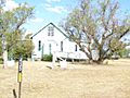
Burndale, 2015
|
|||||||||||||||

Swan Creek
Location in Queensland
|
|||||||||||||||
| Population | 139 (2016 census) | ||||||||||||||
| • Density | 5.326/km2 (13.79/sq mi) | ||||||||||||||
| Postcode(s) | 4370 | ||||||||||||||
| Area | 26.1 km2 (10.1 sq mi) | ||||||||||||||
| Time zone | AEST (UTC+10:00) | ||||||||||||||
| Location | |||||||||||||||
| LGA(s) | Southern Downs Region | ||||||||||||||
| State electorate(s) | Southern Downs | ||||||||||||||
| Federal Division(s) | Maranoa | ||||||||||||||
|
|||||||||||||||
Swan Creek is a rural locality in the Southern Downs Region, Queensland, Australia. In the 2016 census, Swan Creek had a population of 139 people.
Contents
History

A creek called Swan Creek first appears on Buxton's 1864 Darling Downs District Map as part of the Canning Downs pastoral run. By 1883 a smaller pastoral run called Swan Creek had been split off from Canning Downs. It is presumed that the creek acquired its name from the presence of swans at the creek.
Heritage listings
Swan Creek has a number of heritage-listed sites, including:
- Cutmore's Road: Burndale
- Stephens Road: White Swan Inn
Education
There are no schools in Swan Creek. The nearest primary schools are Yangan State School in neighbouring Yangan to the east, Freestone State School in neighbouring Freestone to the north, and Warwick East State School in Warwick to the west. The nearest secondary school is Warwick State High School in Warwick.
Images for kids
-

Swan Creek State School, 1911
-
St Andrew's Anglican Church, 2007
-
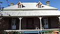
White Swan Inn, 2015

,_Swan_Creek,_2007.jpg)

