
Swat District facts for kids
Quick facts for kids
Swat
سوات
|
|
|---|---|

The Swat River flows through the Swat District
|
|
| Nickname(s):
Switzerland of the East
|
|

|
|
| Country | |
| Province | |
| Capital | Saidu Sharif |
| Largest city | Mingora |
| Area | |
| • District | 5,337 km2 (2,061 sq mi) |
| Population
(2017)
|
|
| • District | 2,309,570 |
| • Density | 432.75/km2 (1,120.81/sq mi) |
| • Urban | 695,900 |
| • Rural | 1,613,670 |
| Time zone | UTC+5 (PKT) |
| Area code(s) | Area code 0946 |
| Languages (1981) | 90.28% Pashto 8.67% Kohistani |
Swat District (Pashto: سوات ولسوالۍ Urdu: ضِلع سوات) is a district in Malakand Division of Khyber Pakhtunkhwa province in Pakistan. Swat is renowned for its outstanding natural beauty. Centred upon the upper portions of the Swat River, Swat was a major centre of early Buddhist thought as part of the Gandhara kingdom, and today is littered with ruins from that era. Swat was home to the last isolated pockets of Gandharan Buddhism, which lasted until the 10th century, well after most of the area had converted to Islam. Until 1969, Swat was part of the Yusafzai State of Swat, a self-governing princely state. The region was seized by the Pakistani Taliban in late 2007, and its tourist industry decimated until Pakistani control over Swat was re-established in mid 2009.
Swat's capital is Saidu Sharif, though the largest city, and main commercial centre, is the nearby city of Mingora. With a population of 2,309,570 according to the 2017 census, Swat is the 15th-largest district of Khyber Pakhtunkhwa. The region is inhabited largely by Yousafzai Pashtuns who arrived in the region in 16 CE from Kabul valley, except in the valley's uppermost reaches, where the Kohistani people dominate.
Swat's average elevation is 980 m (3,220 ft), resulting in a considerably cooler and wetter climate compared to most of Pakistan. With lush forests, verdant alpine meadows, and snow-capped mountains, Swat is one of the country's most popular tourist destinations.
Geography
.jpg)


Swat is surrounded by Chitral, Upper Dir and Lower Dir in the West, Gilgit-Baltistan in North Kohistan, Buner and Shangla in the East and South East. The southern tehsil of Buner was granted the status of a separate district in 1991. Swat Valley is located in northern Khyber Pakhtunkhwa and enclosed by sky-high mountains.
Physical Features: Swat can be divided into two physical regions:
- Mountainous Ranges.
- Plains.
Mountainous ranges
.jpg)
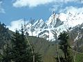
As mentioned above, Swat lies in the lap of mountainous ranges, which are the offshoots of Hindukush, so the larger part of Swat is covered with high mountains and hills, the crests of which are hidden by everlasting snow. Though these gigantic ranges run irregularly: some to the west while the others to the east, the general direction is North-South.
Plains
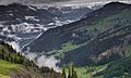
The length of the valley from Landakay to Gabral is 91 miles. Two narrow strips of plains run along the banks of Swat River from Landakay to Madyan. Beyond Madyan in Kohistan-e-Swat, the plain is too little to be mentioned. So far as the width concerns, it is not similar, it varies from place to place. We can say that the average width is 5 miles. The widest portion of the valley is between Barikot and Khwaza Khela. The widest viewpoint and the charming sight where a major portion of the valley is seen is at Gulibagh on the main road, which leads to Madyan.
Economy
Approximately 38% of economy of Swat depends on Tourism and 31% depends on Agriculture.
Agriculture
Gwalerai village located near Mingora is one of those few villages which produces 18 varieties of apples due to its temperate climate in summer. The apple produced here is consumed in Pakistan as well as exported to other countries. It is known as ‘the apple of Swat’. Swat is famous for peach production mostly grown in the valley bottom plains and accounts for about 80% of the peach production of the country. Mostly marketed in the national markets with a brand name of "Swat Peaches". The supply starts from April and continues till September because of a diverse range of varieties grown.
Images for kids
-
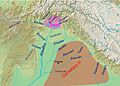
Geography of the Rigveda; the extent of the Swat and Cemetery H cultures are indicated.
-
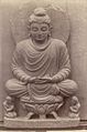
An 1869 photo of a Buddha statue seated on a lotus throne in Swat Valley.
-
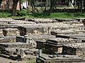
Buddhism heritage site in Swat Valley
-
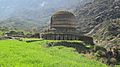
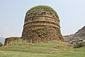
Amlukdara stupa
-
Shingardar Stupa
-
Main Building of Saidu sharif Hospital
-
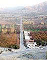
Autumn View of Plains of Swat
-
Sufid Mahal Marghazar Swat valley
-
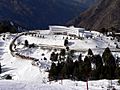
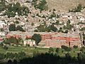
PTDC Motel at Malam Jabba Ski Resort
-
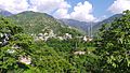
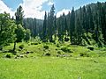
Miandam
-
Utror, Swat valley
-
Ghabral, Swat Valley
-
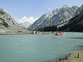
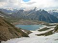
Mahodand Lake, Swat valley
-
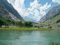
On the way to shahi bagh Lake Swat valley
-
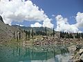
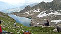
Kundol Lake, Swat valley
-
Spin Khwar Lake Swat valley
-
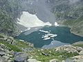
Khapiro Lake
-
Kundol Lake
-
Bashigram lake
-
Daral lake
-
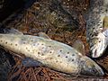
Famous Trout Fish of Swat valley
-
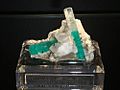
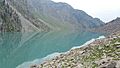
Emerald of Swat Valley Swat valley
-
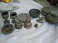
Stone art in Swat Valley
-
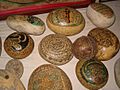
Stone art in Swat Valley
-
Swat Valley – Vintage Silk Embroidery – from the Wovensouls collection


