
Tamura, Fukushima facts for kids
Quick facts for kids
Tamura
田村市
|
|||
|---|---|---|---|

Central Tamura (2015)
|
|||
|
|||

Location of Tamura in Fukushima Prefecture
|
|||

Tamura
Location in Japan
|
|||
| Country | Japan | ||
| Region | Tōhoku | ||
| Prefecture | Fukushima Prefecture | ||
| Area | |||
| • Total | 458.30 km2 (176.95 sq mi) | ||
| Population
(December 2014)
|
|||
| • Total | 37,741 | ||
| • Density | 82.3/km2 (213/sq mi) | ||
| Time zone | UTC+9 (Japan Standard Time) | ||
| - Tree | Oak | ||
| - Flower | Azalea | ||
| - Bird | Japanese bush warbler | ||
| Phone number | 0247-82-1111 | ||
| Address | 76 Funehikimachi Funehiki aza hatazoe, Tamura-shi, Fukushima-ken 963-4393 | ||
| Website | http://www.city.tamura.lg.jp/ | ||


Tamura (田村市, Tamura-shi) is a city in Fukushima, Japan. Tamura was created on March 1, 2005 by combining several towns towns and villages from the Tamura District. They were Funehiki, Ōgoe, Takine, and Tokiwa, and Miyakoji. Between 1 March and 31 August 2011, many people moved to Tamura. The population actually went up by about 1,000 people, or 2%.
Landmarks
There are two well-known places to visit in Takine-cho. Abukuma Limestone Caves and the Hoshi no Mura ("Village of Stars") Observatory are popular with tourists.
Sister cities
Tamura has a only one international sister city:
And, one sister city in Japan:
Related pages
Images for kids
-
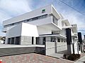
Tamura City Hall
-
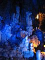
Abukuma Cave
.JPG)

See also
 In Spanish: Tamura (Fukushima) para niños

All content from Kiddle encyclopedia articles (including the article images and facts) can be freely used under Attribution-ShareAlike license, unless stated otherwise. Cite this article:
Tamura, Fukushima Facts for Kids. Kiddle Encyclopedia.