
Tandragee facts for kids
Quick facts for kids Tandragee
|
|
|---|---|
 The Square, Tandragee (2009) |
|

|
|
| Population | 3,486 (2011 Census) |
| Irish grid reference | J030462 |
| • Belfast | 25 mi (40 km) |
| District |
|
| County | |
| Country | Northern Ireland |
| Sovereign state | United Kingdom |
| Post town | CRAIGAVON |
| Postcode district | BT62 |
| Dialling code | 028 |
| Police | Northern Ireland |
| Fire | Northern Ireland |
| Ambulance | Northern Ireland |
| EU Parliament | Northern Ireland |
| UK Parliament |
|
| NI Assembly |
|
Tandragee (from Irish: Tóin re Gaoith, meaning "backside to the wind") is a village in County Armagh, Northern Ireland. It is built on a hillside overlooking the Cusher River, in the civil parish of Ballymore and the historic barony of Orior Lower. It had a population of 3,486 people in the 2011 Census.
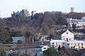
Overlooking the village is Tandragee Castle. Originally the seat of the O'Hanlon sept, the chiefs of Orior, it was taken over by the English during the Plantation of Ulster and rebuilt in about 1837 for The 6th Duke of Manchester. Today, its grounds are home to the Tayto potato-crisp factory.
Northern Ireland Electricity has an interconnector to County Louth in the Republic of Ireland from the outskirts of the town.
Earlier spellings of the name include Tanderagee and Tonregee.
Transport

Tanderagee railway station opened on 6 January 1852 and was shut on 4 January 1965.
There is an airstrip for landing and taking off of small aircraft near the old porridge factory.
Demography
2011 Census
Tandragee had a population of 3,486 people (1,382 households) in the 2011 Census. Of these:
- 23.26% were under 16 years old and 12.62% were aged 65 and above;
- 50.06% of the population were male and 49.94% were female; and
- 81.84% were from a Protestant background and 11.70% were from a Roman Catholic background
2001 Census
Tandragee is classified as an intermediate settlement by the NI Statistics and Research Agency (NISRA) (i.e. with population between 2,050 and 4,500 people). On Census day (29 April 2001) there were 3,050 people living in Tandragee. Of these:
- 24.9% were aged under 16 years and 14.3% were aged 60 and over
- 48.0% of the population were male and 50.0% were female
- 86.9% were from a Protestant background and 10.5% were from a Roman Catholic background
- 2.0% of people aged 16–74 were unemployed.
For more details see: NI Neighbourhood Information Service
Sport
Tandragee Rovers play in the Mid-Ulster Football League.
There is a golf course within the grounds of Tandragee Castle, within walking distance of the main street. It is 5,589 metres, par 71, and a hilly parkland course.
Tandragee is also home to the Tandragee 100, a motorcycle road racing event held each year on country roads near the town.
Despite Tandragee's Protestant majority, the Gaelic Athletic Association also has a presence in the town. Tandragee's Gaelic football team is named "The Redmond O'Hanlons", after the 17th century rapparee of the same name.
Education
- Tandragee Primary School
- Tandragee Junior High School
- Tandragee Nursery
- Button Moon Play Group
Images for kids
-
Tandragee Castle and gate lodge

See also
 In Spanish: Tandragee para niños
