
Tarn-et-Garonne facts for kids
Quick facts for kids
Tarn-et-Garonne
|
|||
|---|---|---|---|
.jpg)
Prefecture building of the Tarn-et-Garonne department, in Montauban
|
|||
|
|||

Location of Tarn-et-Garonne in France
|
|||
| Country | France | ||
| Region | Occitanie | ||
| Département | 4 November 1808 | ||
| Prefecture | Montauban | ||
| Subprefecture | Castelsarrasin | ||
| Area | |||
| • Total | 3,718.3 km2 (1,435.6 sq mi) | ||
| Population
(2014)
|
|||
| • Total | 252,578 | ||
| • Density | 67.9284/km2 (175.9336/sq mi) | ||
| Demonym(s) | Tarn-et-Garonais | ||
| Time zone | UTC+1 (CET) | ||
| • Summer (DST) | UTC+2 (CEST) | ||
| ISO 3166 code | FR-82 | ||
| Arrondissements | 2 | ||
| Cantons | 15 | ||
| Communes | 195 | ||
| Website | Official website: http://www.ledepartement.fr/ | ||


Tarn-et-Garonne is a department in the southwest of France, in the Occitanie region. It is named after the Garonne river and its tributary Tarn. Its prefecture and largest city is Montauban.
Contents
History
Tarn-et-Garonne is not one of the original 83 departments created during the French Revolution on 4 March 1790. It was created on 4 November 1808 during the First French Empire by Napoleon I.
It was formed out of territories belonging to neighboring areas. More than half of the territory was taken from the Lot (including Montauban and Moissac), over one-third was taken from Haute-Garonne (including Castelsarrasin), and the rest from the departments of Lot-et-Garonne, Gers, and Aveyron.
The new department had three arrondissements: Montauban, Castelsarrasin and Moissac. The prefecture was Montauban. On 10 September 1926, the arrondissement of Moissac was eliminated.
Geography

Tarn-et-Garonne is part of the Occitanie region. It has an area of 3,718.3 km2 (1,436 sq mi).
The department borders with 6 departments:
- Occitanie
- Lot (north)
- Aveyron (northeast)
- Tarn (east)
- Haute-Garonne (south)
- Gers (southwest)
- Nouvelle-Aquitaine
- Lot-et-Garonne (northwest)
 |
Lot-et-Garonne | Lot | Aveyron | |
| Tarn | ||||
| Gers | Haute-Garonne |
The highest point in the department, at 504 m (1,654 ft), is the Puech des Carts - Sommet Nord (44°14′43″N 1°57′13″E / 44.24528°N 1.95361°E), in the commune of Castanet.
Even if Tarn-et-Garonne is one of the smallest departments of Metropolitan France, there is a great diversity of landscapes in the department; for example, the plains between the Tarn and Garonne rivers and in the valley of the Aveyron river, the hills of the Lomagne region (southwest of the department) and in the north, including the Causse (a limestone plateau) of the northeast.
The main rivers in the department are the Garonne and its tributaries Tarn and Aveyron.
Climate
The climate of Montauban is an oceanic climate with template summers, Cfb (Marine West Coast Climate) in the Köppen climate classification.
The average amount of precipitation for the year in Montauban is 708.7 mm (27.9 in). The month with the most precipitation on average is October with 71.1 mm (2.8 in) of precipitation. The month with the least precipitation on average is February with an average of 48.3 mm (1.9 in).
The average temperature for the year in Montauban is 13.6 °C (56.5 °F). The warmest month, on average, is July with an average temperature of 22.3 °C (72.1 °F). The coolest month on average is January, with an average temperature of 5.6 °C (42.1 °F).
Administration
Tarn-et-Garonne is managed by the Departamental Council of Tarn-et-Garonne in Montauban. The department is part of the region of Occitanie.
Administrative divisions
There are 2 arrondissements (districts), 15 cantons and 195 communes (municipalities) in Tarn-et-Garonne.
| INSEE code |
Arrondissement | Capital | Population (2014) |
Area (km²) |
Density (Inh./km²) |
Communes |
|---|---|---|---|---|---|---|
| 821 | Castelsarrasin | Castelsarrasin | 76,822 | 1,601.5 | 48.0 | 103 |
| 822 | Montauban | Montauban | 175,756 | 2,116.8 | 83.0 | 92 |
The following is a list of the 15 cantons of the Tarn-et-Garonne department (with their INSEE codes), following the French canton reorganisation which came into effect in March 2015:
- Aveyron-Lère (8201)
- Beaumont-de-Lomagne (8202)
- Castelsarrasin (8203)
- Garonne-Lomagne-Brulhois (8204)
- Moissac (8205)
- Montauban-1 (8206)
- Montauban-2 (8207)
- Montauban-3 (8208)
- Montech (8209)
- Pays de Serres Sud-Quercy (8210)
- Quercy-Aveyron (8211)
- Quercy-Rouergue (8212)
- Tarn-Tescou-Quercy vert (8213)
- Valence (8214)
- Verdun-sur-Garonne (8215)
Demographics
The inhabitants of Tarn-et-Garonne are known, in French, as Tarn-et-Garonnais (women: Tarn-et-Garonnaises).
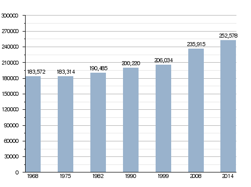
As of 2014[update], Tarn-et-Garonne had a population of 252,578, for a population density of 67.9 inhabitants/km2. The arrondissement of Montauban, with 175,756 inhabitants, is the arrondissement with more inhabitants. The arrondissement of Castelsarrasin has 76,822 inhabitants.
The city with more people living in it is the capital, Montauban (58,826). The subprefecture of Castelsarrasin has 13,765 inhabitants.
Evolution of the population in Tarn-et-Garonne
The cities with more than 5,000 inhabitants in the department are:
| City | Population (2014) |
Arrondissement |
|---|---|---|
| Montauban | 58,826 | Montauban |
| Castelsarrasin | 13,765 | Castelsarrasin |
| Moissac | 12,408 | Castelsarrasin |
| Caussade | 6,805 | Montauban |
| Montech | 6,158 | Montauban |
| Nègrepelisse | 5,511 | Montauban |
| Valence | 5,194 | Castelsarrasin |
Gallery
-
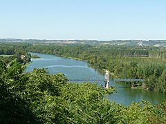
The Garonne river seen from Auvillar
-
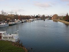
Port Jacques-Yves Cousteau, Castelsarrasin
-
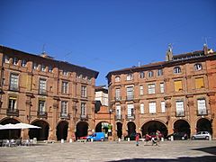
Montauban - Place National


Related pages
Images for kids
-
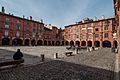
National square in Montauban
-
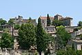
Bruniquel, one of the formally listed "Most Beautiful Villages of France"
-
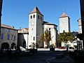
Saint Barthelemy church in Lauzerte
-

The "King's House" in Saint-Antonin-Noble-Val
-
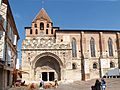
Saint Peter abbey in Moissac
-

Château de Montauriol, seat of the Departmental Council of Tarn-et-Garonne


.jpg)
See also
 In Spanish: Tarn y Garona para niños
