
Tatra mountains facts for kids


The Tatra Mountains, Tatras or Tatra (Tatry in both Slovak and Polish), constitute a mountain range which forms a natural border between Slovakia and Poland. They occupy an area of 750 km², the major part (600 km²) of which lies in Slovakia. The highest Tatra peak, at 2655 m, is Gerlachovský štít, located in Slovakia. Rysy, at 2499 m, is the highest Polish peak.
The Tatra Mountains are the highest mountain range in the Carpathian Mountains. Although considerably smaller than the Alps, they are classified as having an alpine landscape. Their high mountain character, combined with great accessibility, makes them popular with tourists and scientists.
Ján Lacika, Tatras (2nd edition), Bratislava 2006. ISBN: 80-88975-95-6
Contents
Commercial tourism-oriented websites
Mountaineering
Photography
Films
Images for kids
-
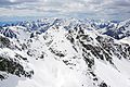
Snow covered Tatras in May 2019.
-
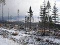
Visible effects of the 2004 storm in Slovakia
-

Gentiana punctata
-
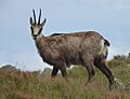
Tatra chamois (Rupicapra rupicapra tatrica)
-
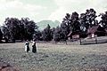
Tourists in Zakopane enjoying views of Giewont in 1938.
-
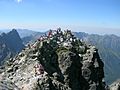
Crowded Rysy peak
-
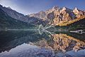
Morskie Oko


.JPG)


See also
 In Spanish: Montes Tatras para niños
