
Tech (river) facts for kids
Quick facts for kids Tech |
|
| River | |
 Pont du Diable (Devil's Bridge) over the Tech, at Céret
|
|
| Country | |
|---|---|
| Region | Languedoc-Roussillon |
| Departments | Pyrénées-Orientales |
| Tributaries | |
| - left | Coumelade, Riuferrer, Ample |
| - right | Lamanère, Maureillas, Tanyari |
| Landmark | Pont del Diable of Ceret |
| Source | Roc Colom |
| - location | Prats-de-Mollo-la-Preste, Pyrénées-Orientales, France |
| - elevation | 2,345 m (7,694 ft) |
| - coordinates | 42°25′23″N 2°19′20″E / 42.42306°N 2.32222°E |
| Mouth | Mediterranean Sea |
| - location | to the north of Argelès-sur-Mer, Pyrénées-Orientales, France |
| - elevation | 0 m (0 ft) |
| - coordinates | 42°35′26″N 3°2′42″E / 42.59056°N 3.04500°E |
| Length | 84.1 km (52 mi) |
| Basin | 721 km² (278 sq mi) |
| Discharge | for Argelès-sur-Mer |
| - average | 8.54 m³/s (302 cu ft/s) |
The Tech (Catalan: Tec) is a river in southeastern France, close to the French-Spanish border. It runs through a valley in the department of the Pyrénées-Orientales, in the former Roussillon. Its drainage basin is the southernmost river basin of Metropolitan France.
The river gives its name to two communes in the department: Le Tech and Arles-sur-Tech.
Geography
The source of the Tech is on the eastern side of Roc Colom in the Pyrenees at an elevation of 2,345 m (7,694 ft), in the commune of Prats-de-Mollo-la-Preste.
It flows generally from southwest to northeast, first through the valley of Vallespir just to Ceret, and then through the Plain of Rosillon.
The Tech flows into the Mediterranean Sea at the Natural Reserve of Mas Larrieu, also called "Mouth of the Tech", to the north of the town of Argelès-sur-Mer.
The Tech river is 84.1 km (52.3 mi) long and its drainage basin has an area of approximately 721 km2 (278 sq mi). The basin is composed of two areas that are quite different:
- An area of mountains, from the source to the town of Ceret, with forests on the mountains.
- A flat area, from Ceret to the sea. Here the river flows through the Plain de Rosillon with many farms where different crops are grown.
The flow of the Tech river was observed over a period of 38 years (1979-2013) in Argelès-sur-Mer, touristic town near the mouth of the river.
The discharge of the river at this location is 8.54 m3 per second.
Both the valley of the Tech and its mouth are part of Natura 2000, an ecological network of protected areas in the European Union.

Tributaries
The Tech has 22 tributaries; the longest tributaries are:
- Right tributaries:
- Lamanère, 15.7 km.
- Maureillas, 16.1 km.
- Tanyari, 13.3 km.
- Left tributaries
- Coumelade, 15 km.
- Riuferrer, 17.7 km.
- Ample, 15.7 km.

Cantons along the river
The Tech is entirely in the department of Pyrénées-Orientales. It crosses two arrondissements, six cantons and 25 communes. The two arrondissements are Céret and Perpignan.
As for the cantons, the Tech has its source in the canton of Prats-de-Mollo-la-Preste, and then flows through the cantons of Arles-sur-Tech, Canton Ceret, Thuir Canton, Canton Elne and finally Argelès-sur-Mer.
Landmark
The Pont del Diable ("Devil's bridge") or Pont Vieux ("Old bridge") at Céret over the river Tech.
Gallery
-
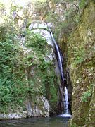
Salt de Maria Valenta fall, Arles-sur-Tech
-
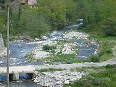
Confluence of the Coumelade and the Tech
-
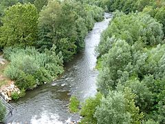
Le Tech river, Céret
-
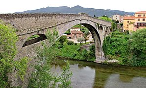
Le Pont du Diable (The Devil's bridge), Céret


See also
 In Spanish: Río Tec para niños
