
Temerin facts for kids
Quick facts for kids
Temerin
Темерин (Serbian)
|
||
|---|---|---|

Town center of Temerin
|
||
|
||
 |
||
| Area | ||
| • Total | 170 km2 (70 sq mi) | |
| Population
(2011 census)
|
||
| • Municipality | Town | |
| Area code | +381 21 | |

Temerin is a town and municipality in South Bačka District, Vojvodina, Serbia. The municipality of Temerin includes the towns of Temerin and Bački Jarak, and villages Sirig and Kamendin. In the 2002 census, the town of Temerin had a population of 19,143, and the municipality had a population of 28,201. Most of its inhabitants are Serbs, while the largest minority in the town and municipality are Hungarians.
Geography
Temerin is located in Pannonian plain, about 20 km north of Novi Sad, the seat of the district. It is first mentioned in 1332 in the receipt by the pope Then Temerin was part of Kingdom of Hungary. Ottomans conquered it 1526, after Battle of Mohacz. Temerin stayed in Ottoman possession until Great Turkish War at the end of 17th century, when it became part of Austrian Empire. After World War I Temerin became part of Yugoslavian state.
Images for kids
-
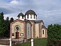
Serbian Orthodox church
-
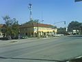
Town center
-
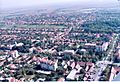
Town centre of Temerin seen from air
-

Wheat field near Temerin
-
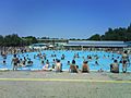
Spa and pool in Temerin


See also
 In Spanish: Temerin para niños
