
Tepezalá facts for kids
Quick facts for kids
Tepezalá
|
|
|---|---|
|
Municipality
|
|

Municipality location in Aguascalientes
|
|

Tepezalá
Location in Mexico
|
|
| Country | Mexico |
| State | Aguascalientes |
| Municipality | Tepezalá |
| Area | |
| • Land | 232.664 km2 (89.832 sq mi) |
| Population
(2015)
|
|
| • Total | 20,926 |
| • Density | 89.9/km2 (233/sq mi) |
Tepezalá is a municipality and town in the Mexican state of Aguascalientes. The town of Tepezalá serves as the municipal seat for the surrounding municipality of Tepezalá.
Tepezala is located on the foothills of the eastern mountains of the state, a land rich in minerals and arid in vegetation that was on the old Silver Route during the 16th century, which brought so much wealth to the region and help conquer the inhospitable north of Mexico. The town's mines made it famous and brought wealth to the state.
Contents
Demographics
| Historical population | ||
|---|---|---|
| Year | Pop. | ±% |
| 2010 | 19,668 | — |
| 2015 | 20,926 | +6.4% |
| 2020 | 22,485 | +7.5% |
As of the 2015 Mexican Intercensal Survey, Tepezalá municipality has a population of 20,926. As of 2010, the town of Tepezalá had a total population of 4,511. Other than the town of Tepezalá, the municipality had 132 localities, the largest of which (with 2010 populations in parentheses) were: San Antonio (3,345), classified as urban, and El Chayote (1,817), and Carboneras (1,261), classified as rural.
Geography
Climate
| Climate data for Tepezala (1951–2010) | |||||||||||||
|---|---|---|---|---|---|---|---|---|---|---|---|---|---|
| Month | Jan | Feb | Mar | Apr | May | Jun | Jul | Aug | Sep | Oct | Nov | Dec | Year |
| Record high °C (°F) | 31.0 (87.8) |
31.5 (88.7) |
33.0 (91.4) |
37.0 (98.6) |
37.0 (98.6) |
37.0 (98.6) |
35.5 (95.9) |
34.0 (93.2) |
36.0 (96.8) |
32.5 (90.5) |
31.0 (87.8) |
35.0 (95.0) |
37.0 (98.6) |
| Average high °C (°F) | 21.9 (71.4) |
23.7 (74.7) |
26.4 (79.5) |
29.3 (84.7) |
30.7 (87.3) |
29.8 (85.6) |
27.3 (81.1) |
27.0 (80.6) |
26.0 (78.8) |
25.7 (78.3) |
24.2 (75.6) |
22.2 (72.0) |
26.2 (79.2) |
| Daily mean °C (°F) | 12.9 (55.2) |
14.3 (57.7) |
16.8 (62.2) |
19.6 (67.3) |
21.2 (70.2) |
21.4 (70.5) |
19.8 (67.6) |
19.3 (66.7) |
18.7 (65.7) |
17.6 (63.7) |
15.1 (59.2) |
13.3 (55.9) |
17.5 (63.5) |
| Average low °C (°F) | 3.8 (38.8) |
5.0 (41.0) |
7.2 (45.0) |
9.9 (49.8) |
11.8 (53.2) |
12.9 (55.2) |
12.2 (54.0) |
11.6 (52.9) |
11.4 (52.5) |
9.5 (49.1) |
6.0 (42.8) |
4.5 (40.1) |
8.8 (47.8) |
| Record low °C (°F) | −11.0 (12.2) |
−2.0 (28.4) |
−2.0 (28.4) |
0.0 (32.0) |
1.0 (33.8) |
4.5 (40.1) |
5.0 (41.0) |
4.0 (39.2) |
2.0 (35.6) |
1.0 (33.8) |
−2.0 (28.4) |
−5.5 (22.1) |
−11.0 (12.2) |
| Average precipitation mm (inches) | 16.1 (0.63) |
10.3 (0.41) |
5.4 (0.21) |
6.9 (0.27) |
19.4 (0.76) |
59.3 (2.33) |
113.5 (4.47) |
94.6 (3.72) |
74.3 (2.93) |
27.4 (1.08) |
8.1 (0.32) |
11.8 (0.46) |
447.1 (17.60) |
| Average precipitation days (≥ 0.1 mm) | 2.0 | 1.4 | 1.0 | 1.2 | 2.7 | 7.0 | 10.3 | 9.5 | 7.1 | 3.5 | 1.2 | 1.7 | 48.6 |
| Source: Servicio Meteorologico Nacional | |||||||||||||
Gallery
-
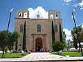
Templo del Nuestra Señora del Refugio, fachada.
-
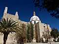
Templo de Nuestra Señora del Refugio, vista lateral.
-

Templo de Nuestra Señora del Refugio, interior.
-
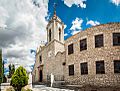
Santuario del Señor de Tepezalá.


See also
 In Spanish: Tepezalá (Aguascalientes) para niños
